[John Durst's grant along the Trinity River]
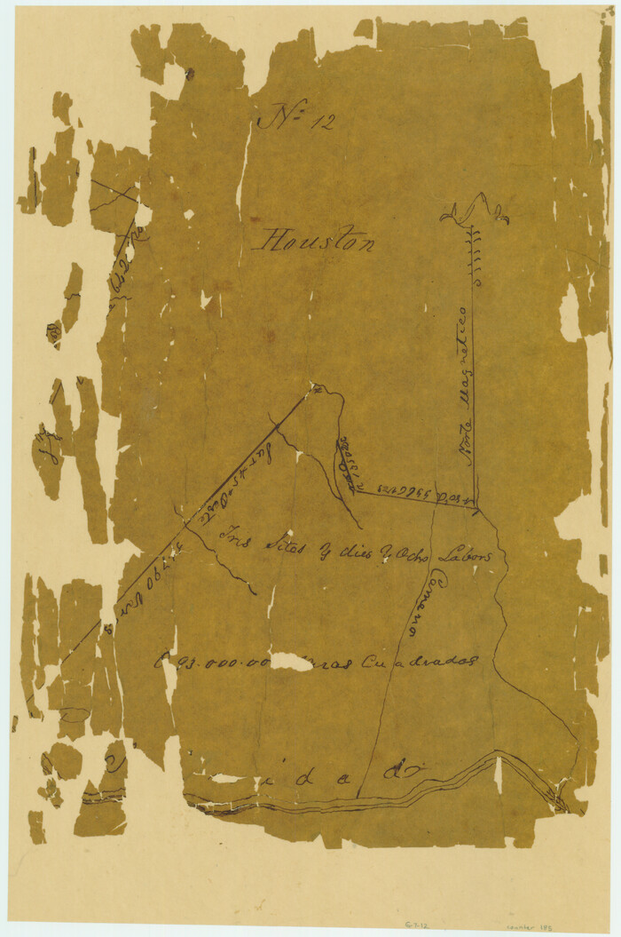
Print $2.00
- Digital $50.00
[John Durst's grant along the Trinity River]
Size: 12.3 x 8.2 inches
185
[Jacob Masters league and those adjoining and Surveys on Elkhart Creek]
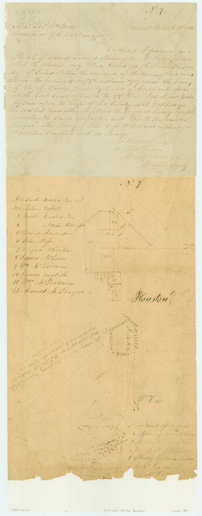
Print $20.00
- Digital $50.00
[Jacob Masters league and those adjoining and Surveys on Elkhart Creek]
1846
Size: 20.3 x 8.0 inches
183
[Cotton Belt] St. Louis Arkansas & Texas R'y, Lufkin Branch, Formely the Kansas & Gulf Short Line
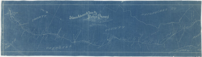
Print $20.00
- Digital $50.00
[Cotton Belt] St. Louis Arkansas & Texas R'y, Lufkin Branch, Formely the Kansas & Gulf Short Line
1888
Size: 11.2 x 39.5 inches
64371
West Part Houston Co.

Print $20.00
- Digital $50.00
West Part Houston Co.
1944
Size: 47.2 x 41.6 inches
77317
Walker County Sketch File 4

Print $4.00
- Digital $50.00
Walker County Sketch File 4
Size: 7.8 x 7.3 inches
39553
Trinity River, Reynard Sheet

Print $20.00
- Digital $50.00
Trinity River, Reynard Sheet
1925
Size: 42.3 x 45.3 inches
65181
Trinity River, Levee Improvement Districts Widths of Floodways

Print $6.00
- Digital $50.00
Trinity River, Levee Improvement Districts Widths of Floodways
1920
Size: 33.3 x 21.7 inches
65251
Trinity River, Clapps Ferry Sheet

Print $20.00
- Digital $50.00
Trinity River, Clapps Ferry Sheet
1925
Size: 47.5 x 36.4 inches
65180
Trinity River, Big Creek Sheet

Print $40.00
- Digital $50.00
Trinity River, Big Creek Sheet
1924
Size: 48.0 x 36.4 inches
65179
Trinity County, Texas

Print $20.00
- Digital $50.00
Trinity County, Texas
1879
Size: 15.8 x 23.8 inches
761
Trinity County Working Sketch 1

Print $20.00
- Digital $50.00
Trinity County Working Sketch 1
1904
Size: 17.1 x 12.3 inches
69449
Trinity County Sketch File 7

Print $6.00
- Digital $50.00
Trinity County Sketch File 7
1857
Size: 11.8 x 8.1 inches
38510
Trinity County Sketch File 29

Print $20.00
- Digital $50.00
Trinity County Sketch File 29
1859
Size: 18.1 x 37.1 inches
12488
Trinity County Sketch File 27

Print $4.00
- Digital $50.00
Trinity County Sketch File 27
Size: 12.0 x 8.6 inches
38562
Trinity County Sketch File 20

Print $20.00
- Digital $50.00
Trinity County Sketch File 20
Size: 21.3 x 27.9 inches
12485
Trinity County Sketch File 2

Print $36.00
- Digital $50.00
Trinity County Sketch File 2
1855
Size: 10.3 x 8.2 inches
38490
Trinity County Sketch File 16

Print $4.00
- Digital $50.00
Trinity County Sketch File 16
1879
Size: 8.2 x 11.1 inches
38544
Trinity County Rolled Sketch 6

Print $20.00
- Digital $50.00
Trinity County Rolled Sketch 6
1999
Size: 25.0 x 19.3 inches
8053
Topographic Map, Reynard Sheet, Trinity River; Houston and Leon Counties

Print $20.00
- Digital $50.00
Topographic Map, Reynard Sheet, Trinity River; Houston and Leon Counties
1925
Size: 45.6 x 41.4 inches
2469
The Republic County of Houston. Spring 1842

Print $20.00
The Republic County of Houston. Spring 1842
2020
Size: 19.7 x 21.8 inches
96182
The Republic County of Houston. January 30, 1841

Print $20.00
The Republic County of Houston. January 30, 1841
2020
Size: 19.7 x 21.8 inches
96179
The Republic County of Houston. February 2, 1842

Print $20.00
The Republic County of Houston. February 2, 1842
2020
Size: 19.7 x 21.8 inches
96181
The Republic County of Houston. December 6, 1841

Print $20.00
The Republic County of Houston. December 6, 1841
2020
Size: 19.7 x 21.8 inches
96180
The Republic County of Houston. December 29, 1845

Print $20.00
The Republic County of Houston. December 29, 1845
2020
Size: 19.7 x 21.8 inches
96183
The Republic County of Houston. Created, June 12, 1837

Print $20.00
The Republic County of Houston. Created, June 12, 1837
2020
Size: 19.7 x 21.7 inches
96178
St. Louis, Arkansas & Texas R'y, Lufkin Branch, Formerly the Kansas & Gulf Short Line

Print $20.00
- Digital $50.00
St. Louis, Arkansas & Texas R'y, Lufkin Branch, Formerly the Kansas & Gulf Short Line
1888
Size: 10.5 x 42.8 inches
64271
Ramon de la Garza 11 Leagues Houston and Robertson Districts

Print $2.00
- Digital $50.00
Ramon de la Garza 11 Leagues Houston and Robertson Districts
Size: 11.5 x 8.5 inches
181
Neches River, Watershed of the Neches River

Print $6.00
- Digital $50.00
Neches River, Watershed of the Neches River
1925
Size: 34.6 x 28.3 inches
65085
Map showing location of Texas Prison Farms surveyed for the Texas Prison System

Print $20.00
- Digital $50.00
Map showing location of Texas Prison Farms surveyed for the Texas Prison System
1934
Size: 15.6 x 12.3 inches
94277
Map of Houston County

Print $40.00
- Digital $50.00
Map of Houston County
1841
Size: 58.6 x 32.2 inches
1952
[John Durst's grant along the Trinity River]
Print $2.00
- Digital $50.00
[John Durst's grant along the Trinity River]
-
Size
12.3 x 8.2 inches
-
Map/Doc
185
[Jacob Masters league and those adjoining and Surveys on Elkhart Creek]
Print $20.00
- Digital $50.00
[Jacob Masters league and those adjoining and Surveys on Elkhart Creek]
1846
-
Size
20.3 x 8.0 inches
-
Map/Doc
183
-
Creation Date
1846
[Cotton Belt] St. Louis Arkansas & Texas R'y, Lufkin Branch, Formely the Kansas & Gulf Short Line
Print $20.00
- Digital $50.00
[Cotton Belt] St. Louis Arkansas & Texas R'y, Lufkin Branch, Formely the Kansas & Gulf Short Line
1888
-
Size
11.2 x 39.5 inches
-
Map/Doc
64371
-
Creation Date
1888
West Part Houston Co.
Print $20.00
- Digital $50.00
West Part Houston Co.
1944
-
Size
47.2 x 41.6 inches
-
Map/Doc
77317
-
Creation Date
1944
Walker County Sketch File 4
Print $4.00
- Digital $50.00
Walker County Sketch File 4
-
Size
7.8 x 7.3 inches
-
Map/Doc
39553
Trinity River, Reynard Sheet
Print $20.00
- Digital $50.00
Trinity River, Reynard Sheet
1925
-
Size
42.3 x 45.3 inches
-
Map/Doc
65181
-
Creation Date
1925
Trinity River, Levee Improvement Districts Widths of Floodways
Print $6.00
- Digital $50.00
Trinity River, Levee Improvement Districts Widths of Floodways
1920
-
Size
33.3 x 21.7 inches
-
Map/Doc
65251
-
Creation Date
1920
Trinity River, Clapps Ferry Sheet
Print $20.00
- Digital $50.00
Trinity River, Clapps Ferry Sheet
1925
-
Size
47.5 x 36.4 inches
-
Map/Doc
65180
-
Creation Date
1925
Trinity River, Big Creek Sheet
Print $40.00
- Digital $50.00
Trinity River, Big Creek Sheet
1924
-
Size
48.0 x 36.4 inches
-
Map/Doc
65179
-
Creation Date
1924
Trinity County, Texas
Print $20.00
- Digital $50.00
Trinity County, Texas
1879
-
Size
15.8 x 23.8 inches
-
Map/Doc
761
-
Creation Date
1879
Trinity County Working Sketch 1
Print $20.00
- Digital $50.00
Trinity County Working Sketch 1
1904
-
Size
17.1 x 12.3 inches
-
Map/Doc
69449
-
Creation Date
1904
Trinity County Sketch File 7
Print $6.00
- Digital $50.00
Trinity County Sketch File 7
1857
-
Size
11.8 x 8.1 inches
-
Map/Doc
38510
-
Creation Date
1857
Trinity County Sketch File 29
Print $20.00
- Digital $50.00
Trinity County Sketch File 29
1859
-
Size
18.1 x 37.1 inches
-
Map/Doc
12488
-
Creation Date
1859
Trinity County Sketch File 27
Print $4.00
- Digital $50.00
Trinity County Sketch File 27
-
Size
12.0 x 8.6 inches
-
Map/Doc
38562
Trinity County Sketch File 20
Print $20.00
- Digital $50.00
Trinity County Sketch File 20
-
Size
21.3 x 27.9 inches
-
Map/Doc
12485
Trinity County Sketch File 2
Print $36.00
- Digital $50.00
Trinity County Sketch File 2
1855
-
Size
10.3 x 8.2 inches
-
Map/Doc
38490
-
Creation Date
1855
Trinity County Sketch File 16
Print $4.00
- Digital $50.00
Trinity County Sketch File 16
1879
-
Size
8.2 x 11.1 inches
-
Map/Doc
38544
-
Creation Date
1879
Trinity County Rolled Sketch 6
Print $20.00
- Digital $50.00
Trinity County Rolled Sketch 6
1999
-
Size
25.0 x 19.3 inches
-
Map/Doc
8053
-
Creation Date
1999
Topographic Map, Reynard Sheet, Trinity River; Houston and Leon Counties
Print $20.00
- Digital $50.00
Topographic Map, Reynard Sheet, Trinity River; Houston and Leon Counties
1925
-
Size
45.6 x 41.4 inches
-
Map/Doc
2469
-
Creation Date
1925
The Republic County of Houston. Spring 1842
Print $20.00
The Republic County of Houston. Spring 1842
2020
-
Size
19.7 x 21.8 inches
-
Map/Doc
96182
-
Creation Date
2020
The Republic County of Houston. January 30, 1841
Print $20.00
The Republic County of Houston. January 30, 1841
2020
-
Size
19.7 x 21.8 inches
-
Map/Doc
96179
-
Creation Date
2020
The Republic County of Houston. February 2, 1842
Print $20.00
The Republic County of Houston. February 2, 1842
2020
-
Size
19.7 x 21.8 inches
-
Map/Doc
96181
-
Creation Date
2020
The Republic County of Houston. December 6, 1841
Print $20.00
The Republic County of Houston. December 6, 1841
2020
-
Size
19.7 x 21.8 inches
-
Map/Doc
96180
-
Creation Date
2020
The Republic County of Houston. December 29, 1845
Print $20.00
The Republic County of Houston. December 29, 1845
2020
-
Size
19.7 x 21.8 inches
-
Map/Doc
96183
-
Creation Date
2020
The Republic County of Houston. Created, June 12, 1837
Print $20.00
The Republic County of Houston. Created, June 12, 1837
2020
-
Size
19.7 x 21.7 inches
-
Map/Doc
96178
-
Creation Date
2020
St. Louis, Arkansas & Texas R'y, Lufkin Branch, Formerly the Kansas & Gulf Short Line
Print $20.00
- Digital $50.00
St. Louis, Arkansas & Texas R'y, Lufkin Branch, Formerly the Kansas & Gulf Short Line
1888
-
Size
10.5 x 42.8 inches
-
Map/Doc
64271
-
Creation Date
1888
Ramon de la Garza 11 Leagues Houston and Robertson Districts
Print $2.00
- Digital $50.00
Ramon de la Garza 11 Leagues Houston and Robertson Districts
-
Size
11.5 x 8.5 inches
-
Map/Doc
181
Neches River, Watershed of the Neches River
Print $6.00
- Digital $50.00
Neches River, Watershed of the Neches River
1925
-
Size
34.6 x 28.3 inches
-
Map/Doc
65085
-
Creation Date
1925
Map showing location of Texas Prison Farms surveyed for the Texas Prison System
Print $20.00
- Digital $50.00
Map showing location of Texas Prison Farms surveyed for the Texas Prison System
1934
-
Size
15.6 x 12.3 inches
-
Map/Doc
94277
-
Creation Date
1934
Map of Houston County
Print $40.00
- Digital $50.00
Map of Houston County
1841
-
Size
58.6 x 32.2 inches
-
Map/Doc
1952
-
Creation Date
1841