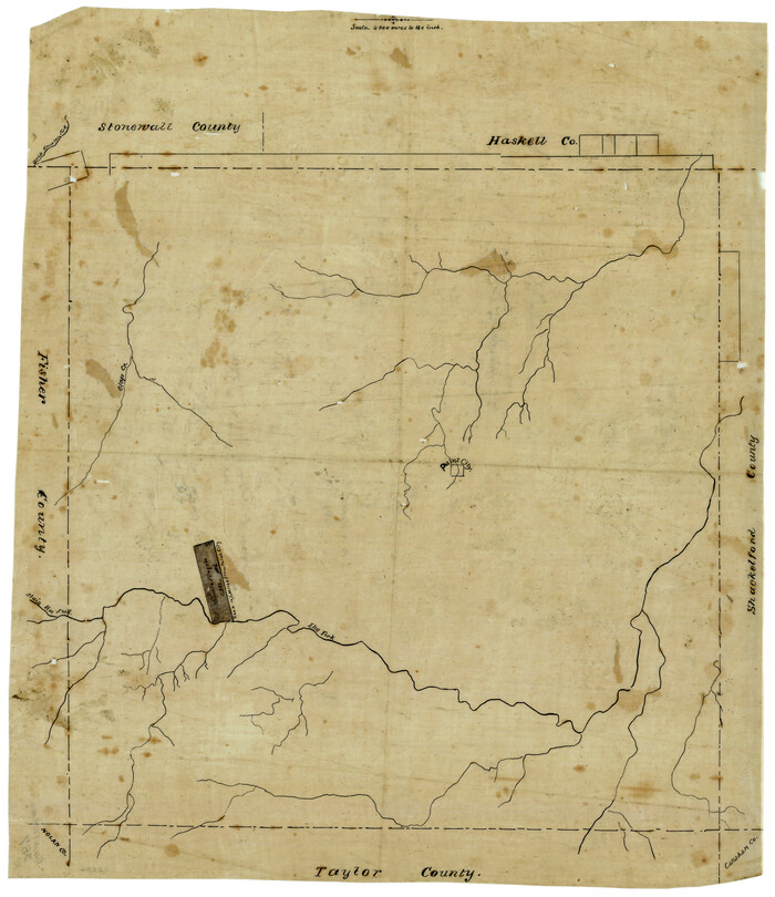
[Surveying sketch of Jones County showing Micaela Fiagoso survey]
Print $20.00
- Digital $50.00
[Surveying sketch of Jones County showing Micaela Fiagoso survey]
Size: 19.5 x 16.8 inches
387
[Sketch of expeditions, trails in Jones, Taylor, Shackelford, Callahan, Buchanan/Stephens and Eastland Counties]
Print $4.00
- Digital $50.00
[Sketch of expeditions, trails in Jones, Taylor, Shackelford, Callahan, Buchanan/Stephens and Eastland Counties]
1873
Size: 10.8 x 18.3 inches
65405
[Sketch of expeditions, trails in Jones, Taylor, Shackelford, Callahan, Buchanan/Stephens and Eastland Counties]
Print $4.00
- Digital $50.00
[Sketch of expeditions, trails in Jones, Taylor, Shackelford, Callahan, Buchanan/Stephens and Eastland Counties]
1873
Size: 10.7 x 18.1 inches
65406
[North 3/4 of County]
Print $20.00
- Digital $50.00
[North 3/4 of County]
1887
Size: 26.0 x 15.4 inches
90840
[Map of Texas and Pacific Blocks from Brazos River westward through Palo Pinto, Stephens, Shackelford, Jones, Callahan, Taylor, Fisher, Nolan and Mitchell Counties]
Print $20.00
- Digital $50.00
[Map of Texas and Pacific Blocks from Brazos River westward through Palo Pinto, Stephens, Shackelford, Jones, Callahan, Taylor, Fisher, Nolan and Mitchell Counties]
Size: 22.0 x 18.5 inches
93456
[Map of Texas and Pacific Blocks from Brazos River westward through Palo Pinto, Stephens, Shackelford, Jones, Callahan, Taylor, Fisher, Nolan and Mitchell Counties]
Print $20.00
- Digital $50.00
[Map of Texas and Pacific Blocks from Brazos River westward through Palo Pinto, Stephens, Shackelford, Jones, Callahan, Taylor, Fisher, Nolan and Mitchell Counties]
Size: 35.0 x 19.3 inches
93457
[Map of Texas and Pacific Blocks from Brazos River westward through Palo Pinto, Stephens, Shackelford, Jones, Callahan, Taylor, Fisher, Nolan and Mitchell Counties]
Print $40.00
- Digital $50.00
[Map of Texas and Pacific Blocks from Brazos River westward through Palo Pinto, Stephens, Shackelford, Jones, Callahan, Taylor, Fisher, Nolan and Mitchell Counties]
Size: 87.1 x 18.8 inches
93460
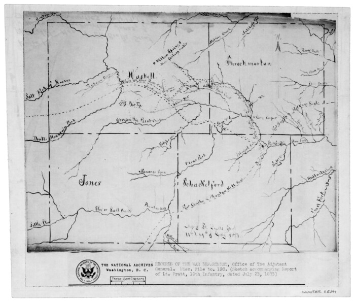
[Map of Lt. Brulls scout in Haskell, Throckmorton, Jones and Shackelford Counties]
Print $3.00
- Digital $50.00
[Map of Lt. Brulls scout in Haskell, Throckmorton, Jones and Shackelford Counties]
1873
Size: 10.1 x 11.9 inches
65399
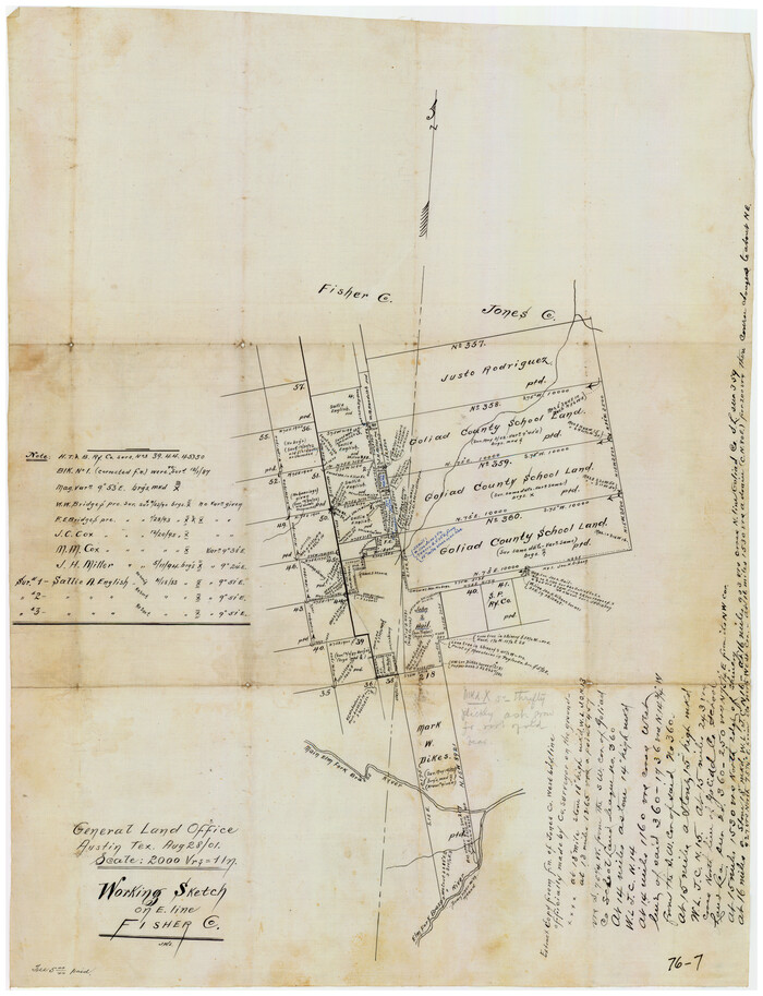
Working Sketch on East Line of Fisher County [from Main Elm Fork of Brazos River along county line to Justo Rodriguez Survey 357]
Print $20.00
- Digital $50.00
Working Sketch on East Line of Fisher County [from Main Elm Fork of Brazos River along county line to Justo Rodriguez Survey 357]
1901
Size: 17.2 x 22.4 inches
90918
Western Waters of the Clear Fork of the Brazos River below Phantom-Hill

Print $20.00
- Digital $50.00
Western Waters of the Clear Fork of the Brazos River below Phantom-Hill
1857
Size: 16.0 x 12.5 inches
4664
Taylor County Working Sketch 8

Print $40.00
- Digital $50.00
Taylor County Working Sketch 8
1953
Size: 73.2 x 43.1 inches
69618
Taylor County Sketch File 9

Print $40.00
- Digital $50.00
Taylor County Sketch File 9
Size: 14.6 x 15.8 inches
37792
Taylor County Sketch File 15

Print $12.00
- Digital $50.00
Taylor County Sketch File 15
1881
Size: 10.1 x 8.1 inches
37805
Stonewall County Sketch File AA1

Print $26.00
- Digital $50.00
Stonewall County Sketch File AA1
1916
Size: 14.3 x 8.6 inches
37288
Stonewall County Sketch File 27

Print $8.00
- Digital $50.00
Stonewall County Sketch File 27
1955
Size: 10.9 x 7.2 inches
37296
Stonewall County Rolled Sketch 17

Print $20.00
- Digital $50.00
Stonewall County Rolled Sketch 17
1927
Size: 20.1 x 30.2 inches
7871
Shackelford County Working Sketch 2

Print $20.00
- Digital $50.00
Shackelford County Working Sketch 2
1914
Size: 17.2 x 17.3 inches
63842
Shackelford County Sketch File 11

Print $20.00
- Digital $50.00
Shackelford County Sketch File 11
1914
Size: 16.8 x 17.0 inches
12317
Shackelford County Rolled Sketch 3

Print $40.00
- Digital $50.00
Shackelford County Rolled Sketch 3
1955
Size: 35.4 x 49.9 inches
9915
S. M. S. Flat Top Ranch

Print $6.00
- Digital $50.00
S. M. S. Flat Top Ranch
1955
Size: 23.2 x 32.8 inches
2102
Reconnaissance Map, Roby Sheet

Print $20.00
- Digital $50.00
Reconnaissance Map, Roby Sheet
1893
Size: 17.0 x 20.8 inches
90869
Map of the Texas & Pacific Railway from Fort Worth to El Paso

Print $40.00
- Digital $50.00
Map of the Texas & Pacific Railway from Fort Worth to El Paso
Size: 24.0 x 76.5 inches
64511
Map of Jones County, Texas

Print $20.00
Map of Jones County, Texas
1879
Size: 24.7 x 18.8 inches
88960
Map of Jones County West of the Clearfork of the Brazos River Young - East of it Milam - Land District

Print $20.00
- Digital $50.00
Map of Jones County West of the Clearfork of the Brazos River Young - East of it Milam - Land District
1859
Size: 22.0 x 26.5 inches
3741
Map of Jones County

Print $20.00
- Digital $50.00
Map of Jones County
1898
Size: 41.2 x 40.0 inches
16862
Map of Jones County

Print $20.00
- Digital $50.00
Map of Jones County
1898
Size: 41.9 x 39.8 inches
4996


Map of Asylum Lands

Print $20.00
- Digital $50.00
Map of Asylum Lands
1857
Size: 28.4 x 18.5 inches
2459
Jones County Working Sketch Graphic Index

Print $20.00
- Digital $50.00
Jones County Working Sketch Graphic Index
1921
Size: 39.5 x 38.6 inches
76599
[Surveying sketch of Jones County showing Micaela Fiagoso survey]
Print $20.00
- Digital $50.00
[Surveying sketch of Jones County showing Micaela Fiagoso survey]
-
Size
19.5 x 16.8 inches
-
Map/Doc
387
[Sketch of expeditions, trails in Jones, Taylor, Shackelford, Callahan, Buchanan/Stephens and Eastland Counties]
Print $4.00
- Digital $50.00
[Sketch of expeditions, trails in Jones, Taylor, Shackelford, Callahan, Buchanan/Stephens and Eastland Counties]
1873
-
Size
10.8 x 18.3 inches
-
Map/Doc
65405
-
Creation Date
1873
[Sketch of expeditions, trails in Jones, Taylor, Shackelford, Callahan, Buchanan/Stephens and Eastland Counties]
Print $4.00
- Digital $50.00
[Sketch of expeditions, trails in Jones, Taylor, Shackelford, Callahan, Buchanan/Stephens and Eastland Counties]
1873
-
Size
10.7 x 18.1 inches
-
Map/Doc
65406
-
Creation Date
1873
[North 3/4 of County]
Print $20.00
- Digital $50.00
[North 3/4 of County]
1887
-
Size
26.0 x 15.4 inches
-
Map/Doc
90840
-
Creation Date
1887
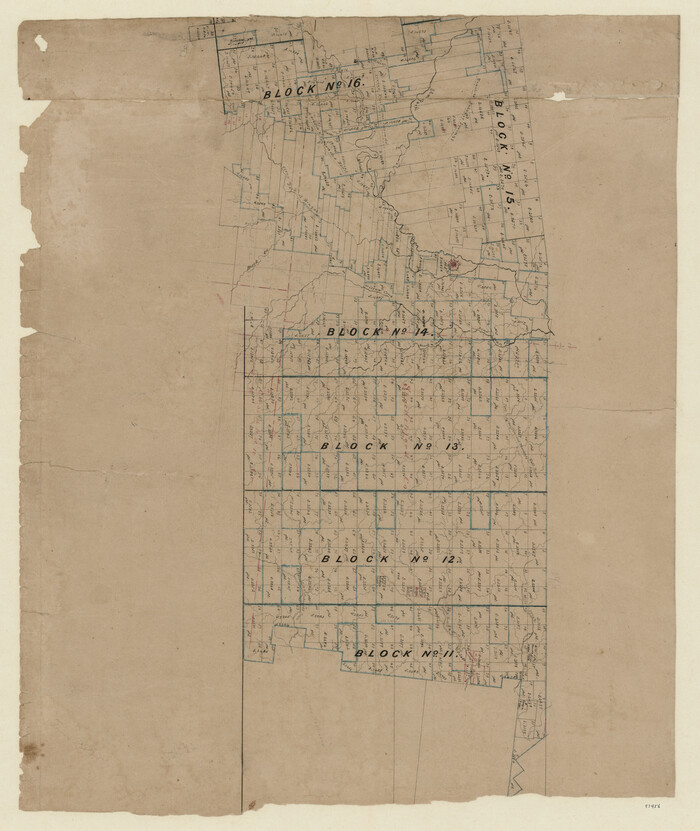
[Map of Texas and Pacific Blocks from Brazos River westward through Palo Pinto, Stephens, Shackelford, Jones, Callahan, Taylor, Fisher, Nolan and Mitchell Counties]
Print $20.00
- Digital $50.00
[Map of Texas and Pacific Blocks from Brazos River westward through Palo Pinto, Stephens, Shackelford, Jones, Callahan, Taylor, Fisher, Nolan and Mitchell Counties]
-
Size
22.0 x 18.5 inches
-
Map/Doc
93456
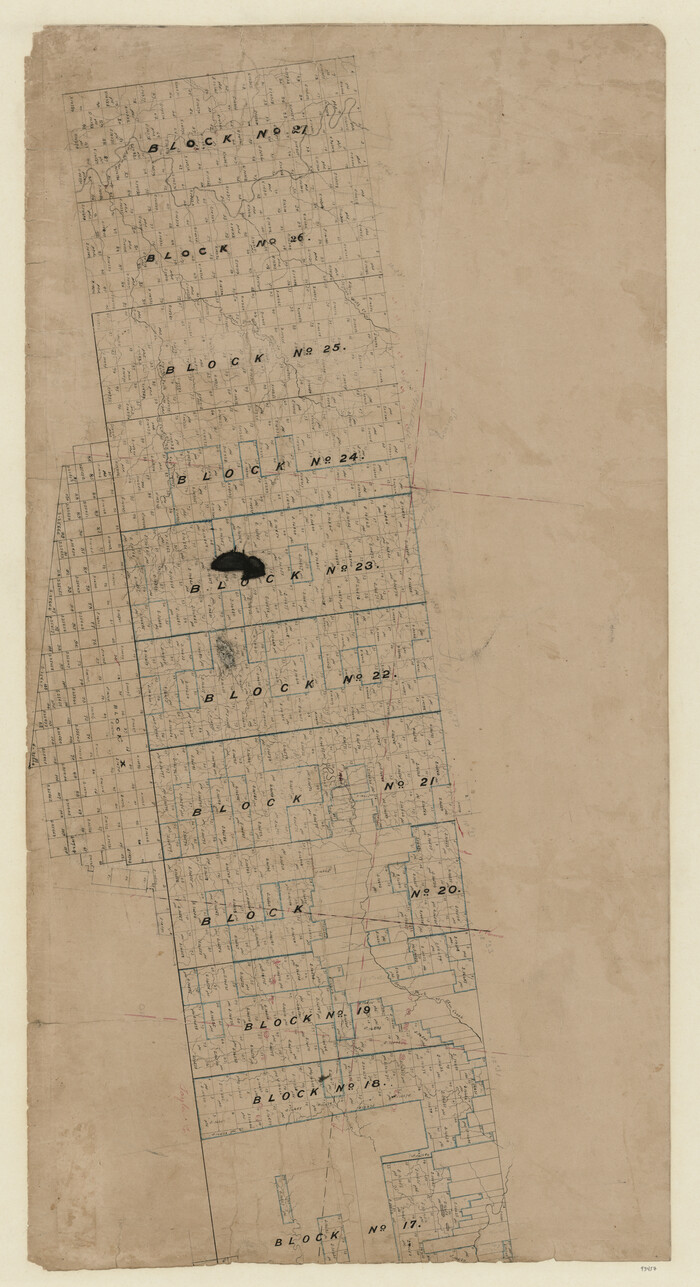
[Map of Texas and Pacific Blocks from Brazos River westward through Palo Pinto, Stephens, Shackelford, Jones, Callahan, Taylor, Fisher, Nolan and Mitchell Counties]
Print $20.00
- Digital $50.00
[Map of Texas and Pacific Blocks from Brazos River westward through Palo Pinto, Stephens, Shackelford, Jones, Callahan, Taylor, Fisher, Nolan and Mitchell Counties]
-
Size
35.0 x 19.3 inches
-
Map/Doc
93457
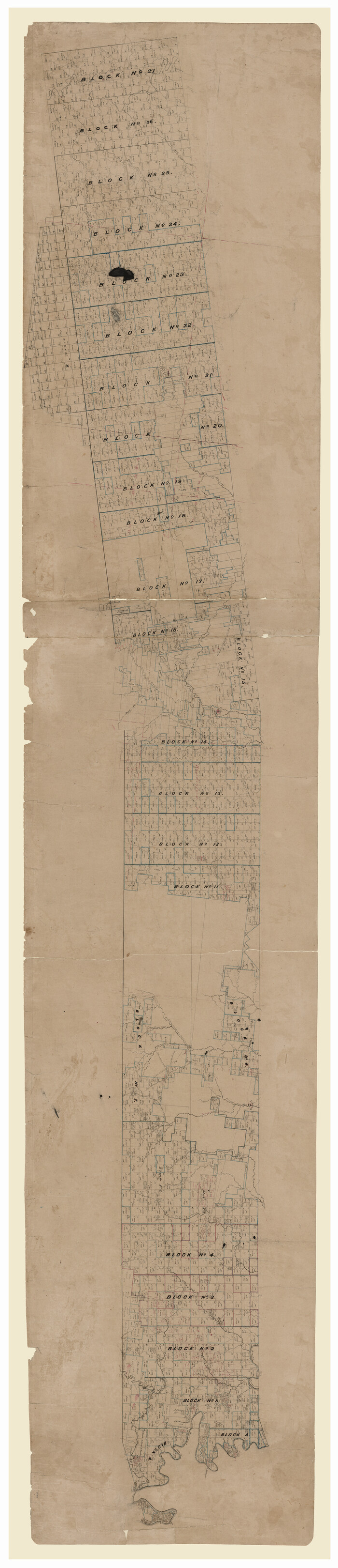
[Map of Texas and Pacific Blocks from Brazos River westward through Palo Pinto, Stephens, Shackelford, Jones, Callahan, Taylor, Fisher, Nolan and Mitchell Counties]
Print $40.00
- Digital $50.00
[Map of Texas and Pacific Blocks from Brazos River westward through Palo Pinto, Stephens, Shackelford, Jones, Callahan, Taylor, Fisher, Nolan and Mitchell Counties]
-
Size
87.1 x 18.8 inches
-
Map/Doc
93460
[Map of Lt. Brulls scout in Haskell, Throckmorton, Jones and Shackelford Counties]
Print $3.00
- Digital $50.00
[Map of Lt. Brulls scout in Haskell, Throckmorton, Jones and Shackelford Counties]
1873
-
Size
10.1 x 11.9 inches
-
Map/Doc
65399
-
Creation Date
1873
Working Sketch on East Line of Fisher County [from Main Elm Fork of Brazos River along county line to Justo Rodriguez Survey 357]
Print $20.00
- Digital $50.00
Working Sketch on East Line of Fisher County [from Main Elm Fork of Brazos River along county line to Justo Rodriguez Survey 357]
1901
-
Size
17.2 x 22.4 inches
-
Map/Doc
90918
-
Creation Date
1901
Western Waters of the Clear Fork of the Brazos River below Phantom-Hill
Print $20.00
- Digital $50.00
Western Waters of the Clear Fork of the Brazos River below Phantom-Hill
1857
-
Size
16.0 x 12.5 inches
-
Map/Doc
4664
-
Creation Date
1857
Taylor County Working Sketch 8
Print $40.00
- Digital $50.00
Taylor County Working Sketch 8
1953
-
Size
73.2 x 43.1 inches
-
Map/Doc
69618
-
Creation Date
1953
Taylor County Sketch File 9
Print $40.00
- Digital $50.00
Taylor County Sketch File 9
-
Size
14.6 x 15.8 inches
-
Map/Doc
37792
Taylor County Sketch File 15
Print $12.00
- Digital $50.00
Taylor County Sketch File 15
1881
-
Size
10.1 x 8.1 inches
-
Map/Doc
37805
-
Creation Date
1881
Stonewall County Sketch File AA1
Print $26.00
- Digital $50.00
Stonewall County Sketch File AA1
1916
-
Size
14.3 x 8.6 inches
-
Map/Doc
37288
-
Creation Date
1916
Stonewall County Sketch File 27
Print $8.00
- Digital $50.00
Stonewall County Sketch File 27
1955
-
Size
10.9 x 7.2 inches
-
Map/Doc
37296
-
Creation Date
1955
Stonewall County Rolled Sketch 17
Print $20.00
- Digital $50.00
Stonewall County Rolled Sketch 17
1927
-
Size
20.1 x 30.2 inches
-
Map/Doc
7871
-
Creation Date
1927
Shackelford County Working Sketch 2
Print $20.00
- Digital $50.00
Shackelford County Working Sketch 2
1914
-
Size
17.2 x 17.3 inches
-
Map/Doc
63842
-
Creation Date
1914
Shackelford County Sketch File 11
Print $20.00
- Digital $50.00
Shackelford County Sketch File 11
1914
-
Size
16.8 x 17.0 inches
-
Map/Doc
12317
-
Creation Date
1914
Shackelford County Rolled Sketch 3
Print $40.00
- Digital $50.00
Shackelford County Rolled Sketch 3
1955
-
Size
35.4 x 49.9 inches
-
Map/Doc
9915
-
Creation Date
1955
S. M. S. Flat Top Ranch
Print $6.00
- Digital $50.00
S. M. S. Flat Top Ranch
1955
-
Size
23.2 x 32.8 inches
-
Map/Doc
2102
-
Creation Date
1955
Reconnaissance Map, Roby Sheet
Print $20.00
- Digital $50.00
Reconnaissance Map, Roby Sheet
1893
-
Size
17.0 x 20.8 inches
-
Map/Doc
90869
-
Creation Date
1893
Map of the Texas & Pacific Railway from Fort Worth to El Paso
Print $40.00
- Digital $50.00
Map of the Texas & Pacific Railway from Fort Worth to El Paso
-
Size
24.0 x 76.5 inches
-
Map/Doc
64511
Map of Jones County, Texas
Print $20.00
Map of Jones County, Texas
1879
-
Size
24.7 x 18.8 inches
-
Map/Doc
88960
-
Creation Date
1879
Map of Jones County West of the Clearfork of the Brazos River Young - East of it Milam - Land District
Print $20.00
- Digital $50.00
Map of Jones County West of the Clearfork of the Brazos River Young - East of it Milam - Land District
1859
-
Size
22.0 x 26.5 inches
-
Map/Doc
3741
-
Creation Date
1859
Map of Jones County
Print $20.00
- Digital $50.00
Map of Jones County
1898
-
Size
41.2 x 40.0 inches
-
Map/Doc
16862
-
Creation Date
1898
Map of Jones County
Print $20.00
- Digital $50.00
Map of Jones County
1898
-
Size
41.9 x 39.8 inches
-
Map/Doc
4996
-
Creation Date
1898
Map of Asylum Lands
Print $20.00
- Digital $50.00
Map of Asylum Lands
1857
-
Size
28.4 x 18.5 inches
-
Map/Doc
2459
-
Creation Date
1857
Jones County Working Sketch Graphic Index
Print $20.00
- Digital $50.00
Jones County Working Sketch Graphic Index
1921
-
Size
39.5 x 38.6 inches
-
Map/Doc
76599
-
Creation Date
1921