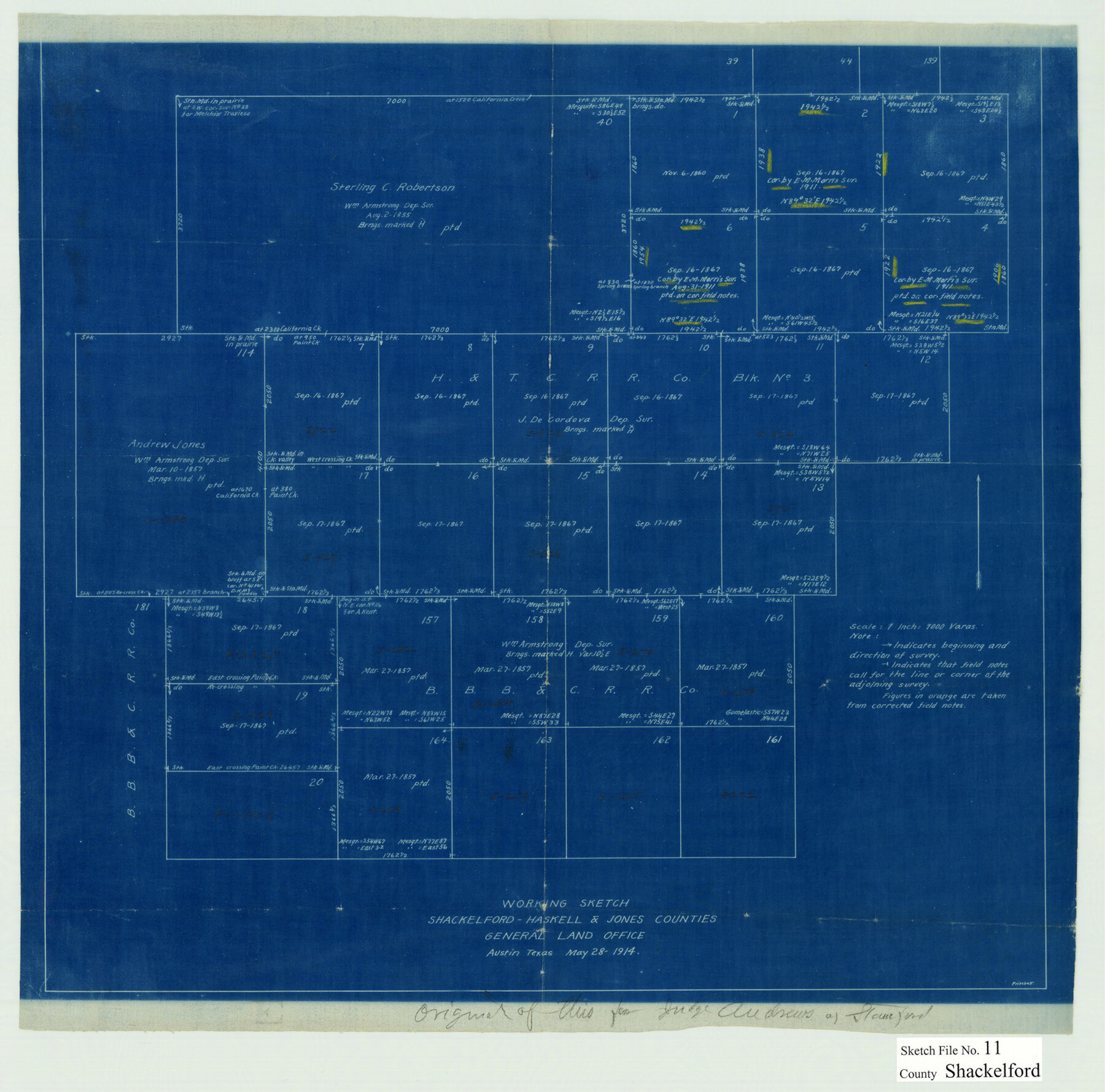
Shackelford County Sketch File 11
[Working sketch of surveys at the intersection of Shackelford, Haskell, and Jones Counties]
-
Map/Doc
12317
-
Collection
General Map Collection
-
Object Dates
5/28/1914 (Creation Date)
-
Counties
Shackelford Haskell Jones
-
Subjects
Surveying Sketch File
-
Height x Width
16.8 x 17.0 inches
42.7 x 43.2 cm
-
Medium
blueprint/diazo
-
Scale
1" = 1000 varas
Part of: General Map Collection
Archer County Working Sketch 24

Print $20.00
- Digital $50.00
Archer County Working Sketch 24
Size 21.0 x 35.8 inches
Map/Doc 67165
Bexar County Working Sketch 6

Print $40.00
- Digital $50.00
Bexar County Working Sketch 6
1945
Size 56.4 x 41.2 inches
Map/Doc 67322
Liberty County Working Sketch 22

Print $20.00
- Digital $50.00
Liberty County Working Sketch 22
1941
Size 19.6 x 26.1 inches
Map/Doc 70481
Hood County Sketch File 22

Print $6.00
- Digital $50.00
Hood County Sketch File 22
Size 15.7 x 9.3 inches
Map/Doc 26615
Township 13 South Ranges 14 and 15 West, South Western District, Louisiana

Print $20.00
- Digital $50.00
Township 13 South Ranges 14 and 15 West, South Western District, Louisiana
1838
Size 19.6 x 24.8 inches
Map/Doc 65857
Polk County Sketch File 7

Print $6.00
- Digital $50.00
Polk County Sketch File 7
1860
Size 12.1 x 7.9 inches
Map/Doc 34131
Brooks County Working Sketch 15

Print $20.00
- Digital $50.00
Brooks County Working Sketch 15
1944
Size 30.5 x 20.5 inches
Map/Doc 67799
Presidio County Rolled Sketch 104

Print $20.00
- Digital $50.00
Presidio County Rolled Sketch 104
1948
Size 26.1 x 40.0 inches
Map/Doc 7386
Flight Mission No. CRC-4R, Frame 74, Chambers County

Print $20.00
- Digital $50.00
Flight Mission No. CRC-4R, Frame 74, Chambers County
1956
Size 18.7 x 22.5 inches
Map/Doc 84878
Bexar County Sketch File 36b

Print $40.00
- Digital $50.00
Bexar County Sketch File 36b
Size 18.6 x 20.2 inches
Map/Doc 10921
Map of Tom Green Co.

Print $40.00
- Digital $50.00
Map of Tom Green Co.
1880
Size 42.3 x 51.2 inches
Map/Doc 80136
Brewster County Rolled Sketch 52

Print $40.00
- Digital $50.00
Brewster County Rolled Sketch 52
1935
Size 24.5 x 59.4 inches
Map/Doc 8479
You may also like
Wharton County Boundary File 1a

Print $12.00
- Digital $50.00
Wharton County Boundary File 1a
Size 11.7 x 9.2 inches
Map/Doc 59851
Zavala County Sketch File 11

Print $4.00
- Digital $50.00
Zavala County Sketch File 11
1885
Size 14.4 x 8.8 inches
Map/Doc 41270
Bell County Working Sketch 7

Print $20.00
- Digital $50.00
Bell County Working Sketch 7
1947
Size 43.7 x 34.9 inches
Map/Doc 67347
The Republic County of Bexar. December 2, 1841

Print $20.00
The Republic County of Bexar. December 2, 1841
2020
Size 14.8 x 21.7 inches
Map/Doc 96098
Aransas County Sketch File 38

Print $244.00
- Digital $50.00
Aransas County Sketch File 38
1996
Size 11.1 x 8.7 inches
Map/Doc 13465
Flight Mission No. CRC-3R, Frame 210, Chambers County

Print $20.00
- Digital $50.00
Flight Mission No. CRC-3R, Frame 210, Chambers County
1956
Size 18.6 x 22.3 inches
Map/Doc 84865
D No. 5 - Reconnaissance of Hatteras Inlet, North Carolina

Print $20.00
- Digital $50.00
D No. 5 - Reconnaissance of Hatteras Inlet, North Carolina
1853
Size 17.1 x 14.9 inches
Map/Doc 97212
Liberty County Working Sketch 85

Print $20.00
- Digital $50.00
Liberty County Working Sketch 85
1987
Size 27.2 x 28.3 inches
Map/Doc 70545
Dimmit County

Print $40.00
- Digital $50.00
Dimmit County
1976
Size 43.2 x 51.7 inches
Map/Doc 95483
Ellis County Working Sketch 4

Print $40.00
- Digital $50.00
Ellis County Working Sketch 4
1997
Size 48.0 x 30.3 inches
Map/Doc 69020
Colorado County Working Sketch 30

Print $20.00
- Digital $50.00
Colorado County Working Sketch 30
1980
Size 22.2 x 19.8 inches
Map/Doc 68130
Hutchinson County Working Sketch 49

Print $20.00
- Digital $50.00
Hutchinson County Working Sketch 49
1988
Size 35.2 x 37.3 inches
Map/Doc 66409