Atascosa County Sketch File 6

Print $26.00
- Digital $50.00
Atascosa County Sketch File 6
Size: 12.2 x 7.8 inches
13752
[Victor Blanco's survey along the San Antonio River]
Print $2.00
- Digital $50.00
[Victor Blanco's survey along the San Antonio River]
Size: 11.2 x 8.2 inches
187
Goliad County Sketch File 26a

Print $10.00
- Digital $50.00
Goliad County Sketch File 26a
Size: 12.8 x 8.3 inches
24321
Gonzales County Sketch File 4

Print $4.00
- Digital $50.00
Gonzales County Sketch File 4
Size: 12.6 x 8.0 inches
24373
Karnes County Sketch File 1

Print $4.00
- Digital $50.00
Karnes County Sketch File 1
Size: 8.8 x 10.7 inches
28545
Karnes County Boundary File 1

Print $14.00
- Digital $50.00
Karnes County Boundary File 1
Size: 8.5 x 7.0 inches
55679
Karnes County Boundary File 2

Print $12.00
- Digital $50.00
Karnes County Boundary File 2
Size: 14.1 x 8.7 inches
55686
Karnes County Boundary File 2a

Print $4.00
- Digital $50.00
Karnes County Boundary File 2a
Size: 12.7 x 8.1 inches
55692
Karnes County Boundary File 3

Print $26.00
- Digital $50.00
Karnes County Boundary File 3
Size: 12.7 x 8.3 inches
55694
Karnes County Boundary File 4

Print $14.00
- Digital $50.00
Karnes County Boundary File 4
Size: 12.7 x 8.2 inches
55698
Karnes County Boundary File 5

Print $32.00
- Digital $50.00
Karnes County Boundary File 5
Size: 12.7 x 8.2 inches
55705
Karnes County Boundary File 5a

Print $4.00
- Digital $50.00
Karnes County Boundary File 5a
Size: 8.1 x 13.3 inches
55721
Karnes County Boundary File 5b

Print $78.00
- Digital $50.00
Karnes County Boundary File 5b
Size: 7.4 x 6.1 inches
55723
Karnes County Boundary File 6

Print $16.00
- Digital $50.00
Karnes County Boundary File 6
Size: 9.3 x 4.0 inches
55735

[Surveys in McMullen and McGloin's Colony along the San Antonio River]
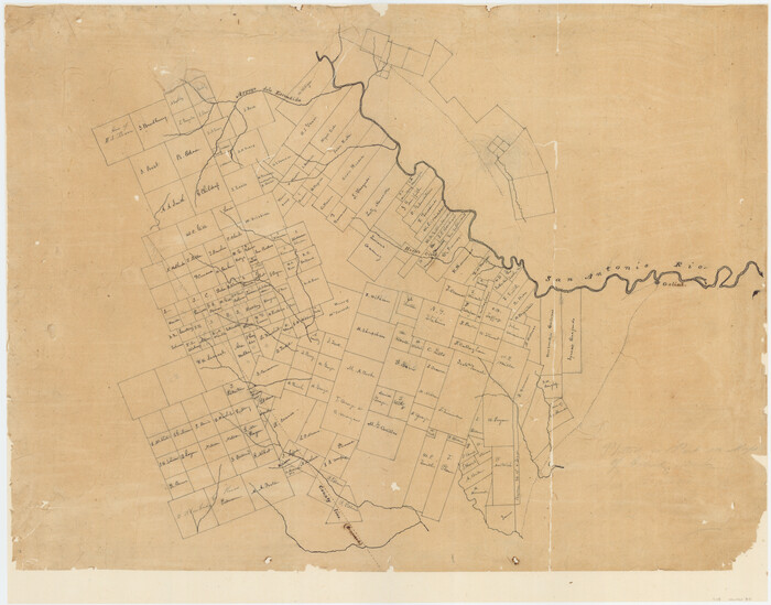
Print $20.00
- Digital $50.00
[Surveys in McMullen and McGloin's Colony along the San Antonio River]
1828
Size: 19.3 x 24.5 inches
30
[Surveys in the Bexar District]
Print $20.00
- Digital $50.00
[Surveys in the Bexar District]
1841
Size: 23.0 x 16.5 inches
24
[Surveys along San Cristoval Creek]
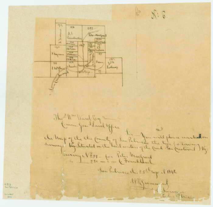
Print $2.00
- Digital $50.00
[Surveys along San Cristoval Creek]
1842
Size: 9.0 x 9.3 inches
300
Map of Bexar County

Print $40.00
- Digital $50.00
Map of Bexar County
1845
Size: 90.6 x 81.0 inches
82242
Map of Bexar County

Print $20.00
- Digital $50.00
Map of Bexar County
1845
Size: 47.4 x 44.9 inches
87234
Map of Bexar County

Print $20.00
- Digital $50.00
Map of Bexar County
1845
Size: 47.5 x 41.7 inches
87235
Map of Bexar County

Print $40.00
- Digital $50.00
Map of Bexar County
1845
Size: 49.0 x 46.5 inches
87236
Map of Bexar County

Print $40.00
- Digital $50.00
Map of Bexar County
1845
Size: 48.8 x 43.0 inches
87237
Karnes County Sketch File 5

Print $7.00
- Digital $50.00
Karnes County Sketch File 5
1849
Size: 8.1 x 10.0 inches
28554
Karnes County Sketch File 2

Print $6.00
- Digital $50.00
Karnes County Sketch File 2
1851
Size: 12.5 x 8.1 inches
28547
Goliad County Sketch File 17

Print $12.00
- Digital $50.00
Goliad County Sketch File 17
1851
Size: 12.4 x 8.2 inches
24249
DeWitt County Sketch File 1

Print $11.00
- Digital $50.00
DeWitt County Sketch File 1
1851
Size: 8.4 x 8.2 inches
20794
Karnes County Sketch File 4

Print $8.00
- Digital $50.00
Karnes County Sketch File 4
1852
Size: 5.5 x 6.8 inches
28550
Goliad County Sketch File 18

Print $100.00
- Digital $50.00
Goliad County Sketch File 18
1854
Size: 12.8 x 15.5 inches
24255
Goliad County Sketch File 26

Print $26.00
- Digital $50.00
Goliad County Sketch File 26
1855
Size: 10.2 x 8.2 inches
24308
Atascosa County Sketch File 6
Print $26.00
- Digital $50.00
Atascosa County Sketch File 6
-
Size
12.2 x 7.8 inches
-
Map/Doc
13752
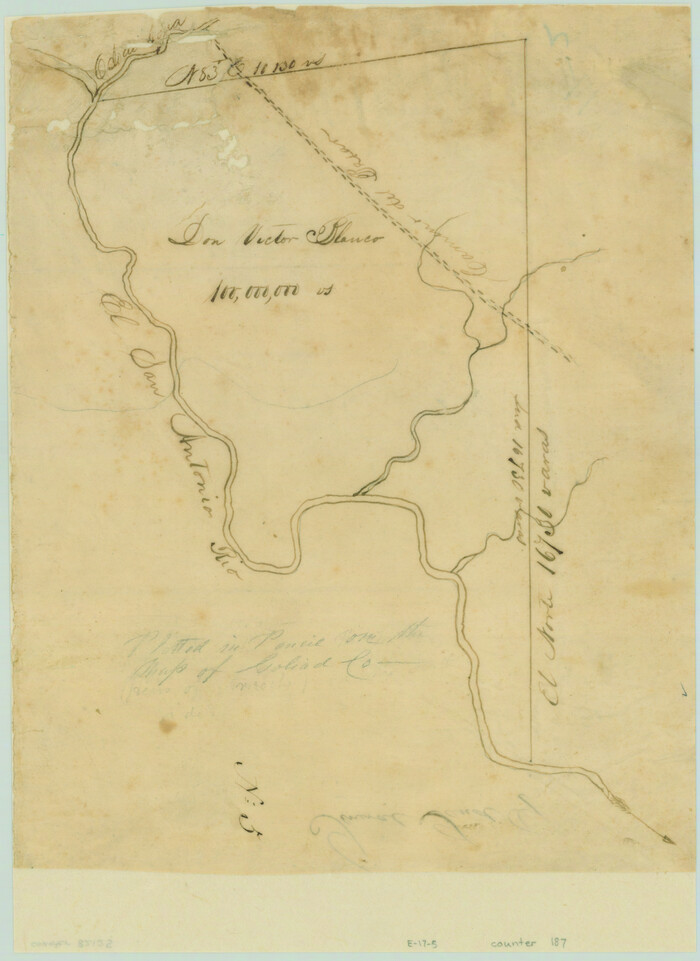
[Victor Blanco's survey along the San Antonio River]
Print $2.00
- Digital $50.00
[Victor Blanco's survey along the San Antonio River]
-
Size
11.2 x 8.2 inches
-
Map/Doc
187
Goliad County Sketch File 26a
Print $10.00
- Digital $50.00
Goliad County Sketch File 26a
-
Size
12.8 x 8.3 inches
-
Map/Doc
24321
Gonzales County Sketch File 4
Print $4.00
- Digital $50.00
Gonzales County Sketch File 4
-
Size
12.6 x 8.0 inches
-
Map/Doc
24373
Karnes County Sketch File 1
Print $4.00
- Digital $50.00
Karnes County Sketch File 1
-
Size
8.8 x 10.7 inches
-
Map/Doc
28545
Karnes County Boundary File 1
Print $14.00
- Digital $50.00
Karnes County Boundary File 1
-
Size
8.5 x 7.0 inches
-
Map/Doc
55679
Karnes County Boundary File 2
Print $12.00
- Digital $50.00
Karnes County Boundary File 2
-
Size
14.1 x 8.7 inches
-
Map/Doc
55686
Karnes County Boundary File 2a
Print $4.00
- Digital $50.00
Karnes County Boundary File 2a
-
Size
12.7 x 8.1 inches
-
Map/Doc
55692
Karnes County Boundary File 3
Print $26.00
- Digital $50.00
Karnes County Boundary File 3
-
Size
12.7 x 8.3 inches
-
Map/Doc
55694
Karnes County Boundary File 4
Print $14.00
- Digital $50.00
Karnes County Boundary File 4
-
Size
12.7 x 8.2 inches
-
Map/Doc
55698
Karnes County Boundary File 5
Print $32.00
- Digital $50.00
Karnes County Boundary File 5
-
Size
12.7 x 8.2 inches
-
Map/Doc
55705
Karnes County Boundary File 5a
Print $4.00
- Digital $50.00
Karnes County Boundary File 5a
-
Size
8.1 x 13.3 inches
-
Map/Doc
55721
Karnes County Boundary File 5b
Print $78.00
- Digital $50.00
Karnes County Boundary File 5b
-
Size
7.4 x 6.1 inches
-
Map/Doc
55723
Karnes County Boundary File 6
Print $16.00
- Digital $50.00
Karnes County Boundary File 6
-
Size
9.3 x 4.0 inches
-
Map/Doc
55735
[Surveys in McMullen and McGloin's Colony along the San Antonio River]
Print $20.00
- Digital $50.00
[Surveys in McMullen and McGloin's Colony along the San Antonio River]
1828
-
Size
19.3 x 24.5 inches
-
Map/Doc
30
-
Creation Date
1828
[Surveys in the Bexar District]
Print $20.00
- Digital $50.00
[Surveys in the Bexar District]
1841
-
Size
23.0 x 16.5 inches
-
Map/Doc
24
-
Creation Date
1841
[Surveys along San Cristoval Creek]
Print $2.00
- Digital $50.00
[Surveys along San Cristoval Creek]
1842
-
Size
9.0 x 9.3 inches
-
Map/Doc
300
-
Creation Date
1842
Map of Bexar County
Print $40.00
- Digital $50.00
Map of Bexar County
1845
-
Size
90.6 x 81.0 inches
-
Map/Doc
82242
-
Creation Date
1845
Map of Bexar County
Print $20.00
- Digital $50.00
Map of Bexar County
1845
-
Size
47.4 x 44.9 inches
-
Map/Doc
87234
-
Creation Date
1845
Map of Bexar County
Print $20.00
- Digital $50.00
Map of Bexar County
1845
-
Size
47.5 x 41.7 inches
-
Map/Doc
87235
-
Creation Date
1845
Map of Bexar County
Print $40.00
- Digital $50.00
Map of Bexar County
1845
-
Size
49.0 x 46.5 inches
-
Map/Doc
87236
-
Creation Date
1845
Map of Bexar County
Print $40.00
- Digital $50.00
Map of Bexar County
1845
-
Size
48.8 x 43.0 inches
-
Map/Doc
87237
-
Creation Date
1845
Karnes County Sketch File 5
Print $7.00
- Digital $50.00
Karnes County Sketch File 5
1849
-
Size
8.1 x 10.0 inches
-
Map/Doc
28554
-
Creation Date
1849
Karnes County Sketch File 2
Print $6.00
- Digital $50.00
Karnes County Sketch File 2
1851
-
Size
12.5 x 8.1 inches
-
Map/Doc
28547
-
Creation Date
1851
Goliad County Sketch File 17
Print $12.00
- Digital $50.00
Goliad County Sketch File 17
1851
-
Size
12.4 x 8.2 inches
-
Map/Doc
24249
-
Creation Date
1851
DeWitt County Sketch File 1
Print $11.00
- Digital $50.00
DeWitt County Sketch File 1
1851
-
Size
8.4 x 8.2 inches
-
Map/Doc
20794
-
Creation Date
1851
Karnes County Sketch File 4
Print $8.00
- Digital $50.00
Karnes County Sketch File 4
1852
-
Size
5.5 x 6.8 inches
-
Map/Doc
28550
-
Creation Date
1852
Goliad County Sketch File 18
Print $100.00
- Digital $50.00
Goliad County Sketch File 18
1854
-
Size
12.8 x 15.5 inches
-
Map/Doc
24255
-
Creation Date
1854
Goliad County Sketch File 26
Print $26.00
- Digital $50.00
Goliad County Sketch File 26
1855
-
Size
10.2 x 8.2 inches
-
Map/Doc
24308
-
Creation Date
1855