[Victor Blanco's survey along the San Antonio River]
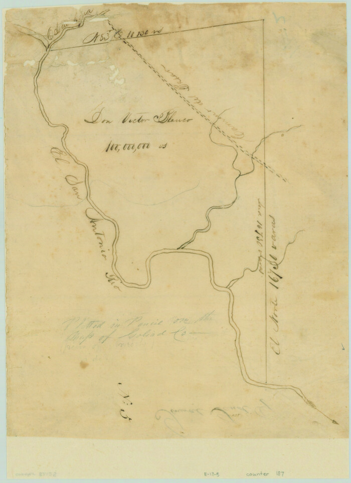
Print $2.00
- Digital $50.00
[Victor Blanco's survey along the San Antonio River]
Size: 11.2 x 8.2 inches
187
[Surveys in the Bexar District]
Print $20.00
- Digital $50.00
[Surveys in the Bexar District]
1841
Size: 23.0 x 16.5 inches
24
[Surveys in McMullen and McGloin's Colony along the San Antonio River]
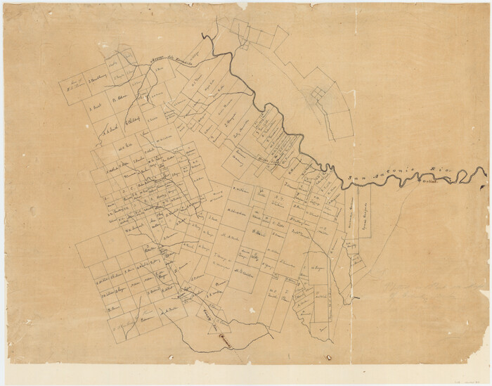
Print $20.00
- Digital $50.00
[Surveys in McMullen and McGloin's Colony along the San Antonio River]
1828
Size: 19.3 x 24.5 inches
30
[Surveys along San Cristoval Creek]
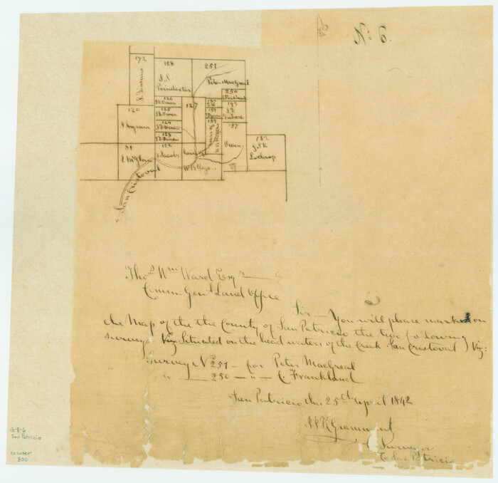
Print $2.00
- Digital $50.00
[Surveys along San Cristoval Creek]
1842
Size: 9.0 x 9.3 inches
300
Wilson County Rolled Sketch 2

Print $20.00
- Digital $50.00
Wilson County Rolled Sketch 2
1941
Size: 30.4 x 26.1 inches
8368
Wilson County Rolled Sketch 1

Print $20.00
- Digital $50.00
Wilson County Rolled Sketch 1
1941
Size: 31.5 x 27.1 inches
8367
Map of Karnes County

Print $20.00
- Digital $50.00
Map of Karnes County
1856
Size: 26.2 x 22.4 inches
3745
Map of Bexar County

Print $40.00
- Digital $50.00
Map of Bexar County
1845
Size: 90.6 x 81.0 inches
82242
Map of Bexar County

Print $20.00
- Digital $50.00
Map of Bexar County
1845
Size: 47.4 x 44.9 inches
87234
Map of Bexar County

Print $20.00
- Digital $50.00
Map of Bexar County
1845
Size: 47.5 x 41.7 inches
87235
Map of Bexar County

Print $40.00
- Digital $50.00
Map of Bexar County
1845
Size: 49.0 x 46.5 inches
87236
Map of Bexar County

Print $40.00
- Digital $50.00
Map of Bexar County
1845
Size: 48.8 x 43.0 inches
87237
Live Oak County Working Sketch 36

Print $20.00
- Digital $50.00
Live Oak County Working Sketch 36
2008
Size: 33.5 x 35.8 inches
88879
Live Oak County Sketch File 19

Print $20.00
- Digital $50.00
Live Oak County Sketch File 19
1879
Size: 24.7 x 18.3 inches
4580

Karnes County, Texas

Print $20.00
- Digital $50.00
Karnes County, Texas
1880
Size: 28.9 x 23.0 inches
524
Karnes County Working Sketch Graphic Index

Print $20.00
- Digital $50.00
Karnes County Working Sketch Graphic Index
1921
Size: 45.0 x 40.3 inches
76600
Karnes County Working Sketch 9

Print $20.00
- Digital $50.00
Karnes County Working Sketch 9
1962
Size: 37.1 x 28.9 inches
66657
Karnes County Working Sketch 8

Print $40.00
- Digital $50.00
Karnes County Working Sketch 8
1962
Size: 51.8 x 36.0 inches
66656
Karnes County Working Sketch 7

Print $20.00
- Digital $50.00
Karnes County Working Sketch 7
1961
Size: 20.8 x 24.2 inches
66655
Karnes County Working Sketch 6

Print $20.00
- Digital $50.00
Karnes County Working Sketch 6
1961
Size: 23.3 x 27.5 inches
66654
Karnes County Working Sketch 5

Print $20.00
- Digital $50.00
Karnes County Working Sketch 5
1960
Size: 37.2 x 36.8 inches
66653
Karnes County Working Sketch 4

Print $20.00
- Digital $50.00
Karnes County Working Sketch 4
1960
Size: 29.3 x 38.8 inches
66652
Karnes County Working Sketch 3

Print $20.00
- Digital $50.00
Karnes County Working Sketch 3
1943
Size: 34.6 x 31.4 inches
66651
Karnes County Working Sketch 2

Print $20.00
- Digital $50.00
Karnes County Working Sketch 2
1939
Size: 18.8 x 20.0 inches
66650
Karnes County Working Sketch 15

Print $20.00
- Digital $50.00
Karnes County Working Sketch 15
1987
Size: 36.0 x 41.1 inches
66663
Karnes County Working Sketch 14
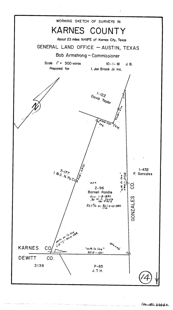
Print $3.00
- Digital $50.00
Karnes County Working Sketch 14
1981
Size: 16.9 x 9.3 inches
66662
Karnes County Working Sketch 13
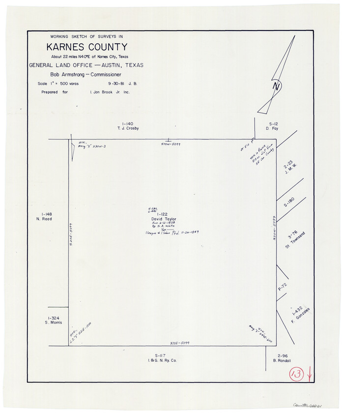
Print $20.00
- Digital $50.00
Karnes County Working Sketch 13
1981
Size: 20.2 x 16.8 inches
66661
Karnes County Working Sketch 12

Print $20.00
- Digital $50.00
Karnes County Working Sketch 12
1975
Size: 36.0 x 45.5 inches
66660
Karnes County Working Sketch 11

Print $40.00
- Digital $50.00
Karnes County Working Sketch 11
1975
Size: 38.1 x 53.6 inches
66659
[Victor Blanco's survey along the San Antonio River]
Print $2.00
- Digital $50.00
[Victor Blanco's survey along the San Antonio River]
-
Size
11.2 x 8.2 inches
-
Map/Doc
187
[Surveys in the Bexar District]
Print $20.00
- Digital $50.00
[Surveys in the Bexar District]
1841
-
Size
23.0 x 16.5 inches
-
Map/Doc
24
-
Creation Date
1841
[Surveys in McMullen and McGloin's Colony along the San Antonio River]
Print $20.00
- Digital $50.00
[Surveys in McMullen and McGloin's Colony along the San Antonio River]
1828
-
Size
19.3 x 24.5 inches
-
Map/Doc
30
-
Creation Date
1828
[Surveys along San Cristoval Creek]
Print $2.00
- Digital $50.00
[Surveys along San Cristoval Creek]
1842
-
Size
9.0 x 9.3 inches
-
Map/Doc
300
-
Creation Date
1842
Wilson County Rolled Sketch 2
Print $20.00
- Digital $50.00
Wilson County Rolled Sketch 2
1941
-
Size
30.4 x 26.1 inches
-
Map/Doc
8368
-
Creation Date
1941
Wilson County Rolled Sketch 1
Print $20.00
- Digital $50.00
Wilson County Rolled Sketch 1
1941
-
Size
31.5 x 27.1 inches
-
Map/Doc
8367
-
Creation Date
1941
Map of Karnes County
Print $20.00
- Digital $50.00
Map of Karnes County
1856
-
Size
26.2 x 22.4 inches
-
Map/Doc
3745
-
Creation Date
1856
Map of Bexar County
Print $40.00
- Digital $50.00
Map of Bexar County
1845
-
Size
90.6 x 81.0 inches
-
Map/Doc
82242
-
Creation Date
1845
Map of Bexar County
Print $20.00
- Digital $50.00
Map of Bexar County
1845
-
Size
47.4 x 44.9 inches
-
Map/Doc
87234
-
Creation Date
1845
Map of Bexar County
Print $20.00
- Digital $50.00
Map of Bexar County
1845
-
Size
47.5 x 41.7 inches
-
Map/Doc
87235
-
Creation Date
1845
Map of Bexar County
Print $40.00
- Digital $50.00
Map of Bexar County
1845
-
Size
49.0 x 46.5 inches
-
Map/Doc
87236
-
Creation Date
1845
Map of Bexar County
Print $40.00
- Digital $50.00
Map of Bexar County
1845
-
Size
48.8 x 43.0 inches
-
Map/Doc
87237
-
Creation Date
1845
Live Oak County Working Sketch 36
Print $20.00
- Digital $50.00
Live Oak County Working Sketch 36
2008
-
Size
33.5 x 35.8 inches
-
Map/Doc
88879
-
Creation Date
2008
Live Oak County Sketch File 19
Print $20.00
- Digital $50.00
Live Oak County Sketch File 19
1879
-
Size
24.7 x 18.3 inches
-
Map/Doc
4580
-
Creation Date
1879
Karnes County, Texas
Print $20.00
- Digital $50.00
Karnes County, Texas
1880
-
Size
28.9 x 23.0 inches
-
Map/Doc
524
-
Creation Date
1880
Karnes County Working Sketch Graphic Index
Print $20.00
- Digital $50.00
Karnes County Working Sketch Graphic Index
1921
-
Size
45.0 x 40.3 inches
-
Map/Doc
76600
-
Creation Date
1921
Karnes County Working Sketch 9
Print $20.00
- Digital $50.00
Karnes County Working Sketch 9
1962
-
Size
37.1 x 28.9 inches
-
Map/Doc
66657
-
Creation Date
1962
Karnes County Working Sketch 8
Print $40.00
- Digital $50.00
Karnes County Working Sketch 8
1962
-
Size
51.8 x 36.0 inches
-
Map/Doc
66656
-
Creation Date
1962
Karnes County Working Sketch 7
Print $20.00
- Digital $50.00
Karnes County Working Sketch 7
1961
-
Size
20.8 x 24.2 inches
-
Map/Doc
66655
-
Creation Date
1961
Karnes County Working Sketch 6
Print $20.00
- Digital $50.00
Karnes County Working Sketch 6
1961
-
Size
23.3 x 27.5 inches
-
Map/Doc
66654
-
Creation Date
1961
Karnes County Working Sketch 5
Print $20.00
- Digital $50.00
Karnes County Working Sketch 5
1960
-
Size
37.2 x 36.8 inches
-
Map/Doc
66653
-
Creation Date
1960
Karnes County Working Sketch 4
Print $20.00
- Digital $50.00
Karnes County Working Sketch 4
1960
-
Size
29.3 x 38.8 inches
-
Map/Doc
66652
-
Creation Date
1960
Karnes County Working Sketch 3
Print $20.00
- Digital $50.00
Karnes County Working Sketch 3
1943
-
Size
34.6 x 31.4 inches
-
Map/Doc
66651
-
Creation Date
1943
Karnes County Working Sketch 2
Print $20.00
- Digital $50.00
Karnes County Working Sketch 2
1939
-
Size
18.8 x 20.0 inches
-
Map/Doc
66650
-
Creation Date
1939
Karnes County Working Sketch 15
Print $20.00
- Digital $50.00
Karnes County Working Sketch 15
1987
-
Size
36.0 x 41.1 inches
-
Map/Doc
66663
-
Creation Date
1987
Karnes County Working Sketch 14
Print $3.00
- Digital $50.00
Karnes County Working Sketch 14
1981
-
Size
16.9 x 9.3 inches
-
Map/Doc
66662
-
Creation Date
1981
Karnes County Working Sketch 13
Print $20.00
- Digital $50.00
Karnes County Working Sketch 13
1981
-
Size
20.2 x 16.8 inches
-
Map/Doc
66661
-
Creation Date
1981
Karnes County Working Sketch 12
Print $20.00
- Digital $50.00
Karnes County Working Sketch 12
1975
-
Size
36.0 x 45.5 inches
-
Map/Doc
66660
-
Creation Date
1975
Karnes County Working Sketch 11
Print $40.00
- Digital $50.00
Karnes County Working Sketch 11
1975
-
Size
38.1 x 53.6 inches
-
Map/Doc
66659
-
Creation Date
1975