Orange County Sketch File 26

Print $20.00
- Digital $50.00
Orange County Sketch File 26
Size: 38.5 x 29.3 inches
10564
Orange County Rolled Sketch 25

Print $20.00
- Digital $50.00
Orange County Rolled Sketch 25
1951
Size: 29.0 x 43.5 inches
10723
Jasper County Sketch File 33

Print $20.00
- Digital $50.00
Jasper County Sketch File 33
1938
Size: 23.0 x 17.6 inches
11854
Orange County Sketch File 9

Print $20.00
- Digital $50.00
Orange County Sketch File 9
1874
Size: 12.7 x 22.9 inches
12117
Orange County Sketch File 14

Print $20.00
- Digital $50.00
Orange County Sketch File 14
Size: 19.9 x 32.9 inches
12118
Orange County Sketch File 16

Print $20.00
- Digital $50.00
Orange County Sketch File 16
Size: 18.1 x 32.8 inches
12119
Orange County Sketch File 22

Print $20.00
- Digital $50.00
Orange County Sketch File 22
1910
Size: 16.2 x 18.7 inches
12121
Orange County Sketch File 25

Print $20.00
- Digital $50.00
Orange County Sketch File 25
1914
Size: 19.6 x 38.2 inches
12122
Orange County Sketch File 27

Print $20.00
- Digital $50.00
Orange County Sketch File 27
1915
Size: 18.6 x 21.8 inches
12123
Orange County Sketch File 30

Print $20.00
- Digital $50.00
Orange County Sketch File 30
1926
Size: 22.7 x 34.4 inches
12124
Orange County Sketch File 31

Print $20.00
- Digital $50.00
Orange County Sketch File 31
1926
Size: 17.9 x 20.0 inches
12125
Orange County Sketch File 34

Print $20.00
- Digital $50.00
Orange County Sketch File 34
1929
Size: 23.5 x 27.7 inches
12126
Orange County Sketch File 39

Print $20.00
- Digital $50.00
Orange County Sketch File 39
1964
Size: 24.2 x 27.9 inches
12127
Orange County Sketch File 40

Print $20.00
- Digital $50.00
Orange County Sketch File 40
1895
Size: 18.2 x 22.7 inches
12128
Orange County Sketch File B

Print $20.00
- Digital $50.00
Orange County Sketch File B
1890
Size: 17.6 x 26.0 inches
12130
Orange County Sabine River Leases 1,2,3,4

Print $20.00
- Digital $50.00
Orange County Sabine River Leases 1,2,3,4
1950
Size: 36.5 x 22.4 inches
1931
Orange County, West Half of Sabine River Showing Leases 5 and 6

Print $20.00
- Digital $50.00
Orange County, West Half of Sabine River Showing Leases 5 and 6
1957
Size: 30.6 x 34.3 inches
1934
Revised map of west half of Sabine Lake and Sabine Pass, showing subdivision for mineral development; Jefferson and Orange Counties

Print $40.00
- Digital $50.00
Revised map of west half of Sabine Lake and Sabine Pass, showing subdivision for mineral development; Jefferson and Orange Counties
1979
Size: 72.1 x 41.5 inches
1935
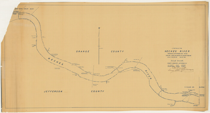
Map of Neches River, Texas from Sabine Lake to Beaumont, Texas

Print $40.00
- Digital $50.00
Map of Neches River, Texas from Sabine Lake to Beaumont, Texas
1910
Size: 32.4 x 104.0 inches
2465
[Neches River Bed, Plat and Calculations]
Print $40.00
- Digital $50.00
[Neches River Bed, Plat and Calculations]
1928
Size: 27.3 x 51.0 inches
2466
Jasper County Sketch File 6

Print $26.00
- Digital $50.00
Jasper County Sketch File 6
1867
Size: 12.8 x 8.2 inches
27771
Jasper County Sketch File 7

Print $22.00
- Digital $50.00
Jasper County Sketch File 7
Size: 12.4 x 15.4 inches
27775
Jasper County Sketch File 8 and 9

Print $80.00
- Digital $50.00
Jasper County Sketch File 8 and 9
Size: 8.2 x 6.9 inches
27777
Jefferson County Sketch file 30

Print $22.00
- Digital $50.00
Jefferson County Sketch file 30
1917
Size: 11.2 x 8.8 inches
28194
Jefferson County Sketch File 54

Print $226.00
- Digital $50.00
Jefferson County Sketch File 54
1961
Size: 11.0 x 8.5 inches
28359
Revised Map of West Half of Sabine Lake, Jefferson & Orange Cos., showing subdivision for mineral development

Print $40.00
- Digital $50.00
Revised Map of West Half of Sabine Lake, Jefferson & Orange Cos., showing subdivision for mineral development
1957
Size: 58.9 x 42.0 inches
2898
Orange County - West one half of Sabine River showing leases 5 & 6 traced from U. S. C. & G. S. chart no. 533

Print $20.00
- Digital $50.00
Orange County - West one half of Sabine River showing leases 5 & 6 traced from U. S. C. & G. S. chart no. 533
1957
Size: 30.6 x 35.4 inches
2899
Orange County - Sabine River Leases 1, 2, 3, & 4

Print $20.00
- Digital $50.00
Orange County - Sabine River Leases 1, 2, 3, & 4
1918
Size: 38.6 x 23.0 inches
2900
Newton County Sketch File 25

Print $4.00
- Digital $50.00
Newton County Sketch File 25
Size: 7.8 x 8.3 inches
32407
[Surveys in the Jefferson District on the Sabine River]
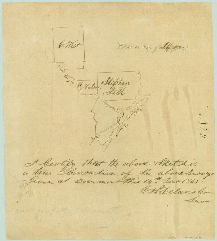
Print $2.00
- Digital $50.00
[Surveys in the Jefferson District on the Sabine River]
1841
Size: 8.7 x 7.8 inches
325
Orange County Sketch File 26
Print $20.00
- Digital $50.00
Orange County Sketch File 26
-
Size
38.5 x 29.3 inches
-
Map/Doc
10564
Orange County Rolled Sketch 25
Print $20.00
- Digital $50.00
Orange County Rolled Sketch 25
1951
-
Size
29.0 x 43.5 inches
-
Map/Doc
10723
-
Creation Date
1951
Jasper County Sketch File 33
Print $20.00
- Digital $50.00
Jasper County Sketch File 33
1938
-
Size
23.0 x 17.6 inches
-
Map/Doc
11854
-
Creation Date
1938
Orange County Sketch File 9
Print $20.00
- Digital $50.00
Orange County Sketch File 9
1874
-
Size
12.7 x 22.9 inches
-
Map/Doc
12117
-
Creation Date
1874
Orange County Sketch File 14
Print $20.00
- Digital $50.00
Orange County Sketch File 14
-
Size
19.9 x 32.9 inches
-
Map/Doc
12118
Orange County Sketch File 16
Print $20.00
- Digital $50.00
Orange County Sketch File 16
-
Size
18.1 x 32.8 inches
-
Map/Doc
12119
Orange County Sketch File 22
Print $20.00
- Digital $50.00
Orange County Sketch File 22
1910
-
Size
16.2 x 18.7 inches
-
Map/Doc
12121
-
Creation Date
1910
Orange County Sketch File 25
Print $20.00
- Digital $50.00
Orange County Sketch File 25
1914
-
Size
19.6 x 38.2 inches
-
Map/Doc
12122
-
Creation Date
1914
Orange County Sketch File 27
Print $20.00
- Digital $50.00
Orange County Sketch File 27
1915
-
Size
18.6 x 21.8 inches
-
Map/Doc
12123
-
Creation Date
1915
Orange County Sketch File 30
Print $20.00
- Digital $50.00
Orange County Sketch File 30
1926
-
Size
22.7 x 34.4 inches
-
Map/Doc
12124
-
Creation Date
1926
Orange County Sketch File 31
Print $20.00
- Digital $50.00
Orange County Sketch File 31
1926
-
Size
17.9 x 20.0 inches
-
Map/Doc
12125
-
Creation Date
1926
Orange County Sketch File 34
Print $20.00
- Digital $50.00
Orange County Sketch File 34
1929
-
Size
23.5 x 27.7 inches
-
Map/Doc
12126
-
Creation Date
1929
Orange County Sketch File 39
Print $20.00
- Digital $50.00
Orange County Sketch File 39
1964
-
Size
24.2 x 27.9 inches
-
Map/Doc
12127
-
Creation Date
1964
Orange County Sketch File 40
Print $20.00
- Digital $50.00
Orange County Sketch File 40
1895
-
Size
18.2 x 22.7 inches
-
Map/Doc
12128
-
Creation Date
1895
Orange County Sketch File B
Print $20.00
- Digital $50.00
Orange County Sketch File B
1890
-
Size
17.6 x 26.0 inches
-
Map/Doc
12130
-
Creation Date
1890
Orange County Sabine River Leases 1,2,3,4
Print $20.00
- Digital $50.00
Orange County Sabine River Leases 1,2,3,4
1950
-
Size
36.5 x 22.4 inches
-
Map/Doc
1931
-
Creation Date
1950
Orange County, West Half of Sabine River Showing Leases 5 and 6
Print $20.00
- Digital $50.00
Orange County, West Half of Sabine River Showing Leases 5 and 6
1957
-
Size
30.6 x 34.3 inches
-
Map/Doc
1934
-
Creation Date
1957
Revised map of west half of Sabine Lake and Sabine Pass, showing subdivision for mineral development; Jefferson and Orange Counties
Print $40.00
- Digital $50.00
Revised map of west half of Sabine Lake and Sabine Pass, showing subdivision for mineral development; Jefferson and Orange Counties
1979
-
Size
72.1 x 41.5 inches
-
Map/Doc
1935
-
Creation Date
1979
Map of Neches River, Texas from Sabine Lake to Beaumont, Texas
Print $40.00
- Digital $50.00
Map of Neches River, Texas from Sabine Lake to Beaumont, Texas
1910
-
Size
32.4 x 104.0 inches
-
Map/Doc
2465
-
Creation Date
1910
[Neches River Bed, Plat and Calculations]
Print $40.00
- Digital $50.00
[Neches River Bed, Plat and Calculations]
1928
-
Size
27.3 x 51.0 inches
-
Map/Doc
2466
-
Creation Date
1928
Jasper County Sketch File 6
Print $26.00
- Digital $50.00
Jasper County Sketch File 6
1867
-
Size
12.8 x 8.2 inches
-
Map/Doc
27771
-
Creation Date
1867
Jasper County Sketch File 7
Print $22.00
- Digital $50.00
Jasper County Sketch File 7
-
Size
12.4 x 15.4 inches
-
Map/Doc
27775
Jasper County Sketch File 8 and 9
Print $80.00
- Digital $50.00
Jasper County Sketch File 8 and 9
-
Size
8.2 x 6.9 inches
-
Map/Doc
27777
Jefferson County Sketch file 30
Print $22.00
- Digital $50.00
Jefferson County Sketch file 30
1917
-
Size
11.2 x 8.8 inches
-
Map/Doc
28194
-
Creation Date
1917
Jefferson County Sketch File 54
Print $226.00
- Digital $50.00
Jefferson County Sketch File 54
1961
-
Size
11.0 x 8.5 inches
-
Map/Doc
28359
-
Creation Date
1961
Revised Map of West Half of Sabine Lake, Jefferson & Orange Cos., showing subdivision for mineral development
Print $40.00
- Digital $50.00
Revised Map of West Half of Sabine Lake, Jefferson & Orange Cos., showing subdivision for mineral development
1957
-
Size
58.9 x 42.0 inches
-
Map/Doc
2898
-
Creation Date
1957
Orange County - West one half of Sabine River showing leases 5 & 6 traced from U. S. C. & G. S. chart no. 533
Print $20.00
- Digital $50.00
Orange County - West one half of Sabine River showing leases 5 & 6 traced from U. S. C. & G. S. chart no. 533
1957
-
Size
30.6 x 35.4 inches
-
Map/Doc
2899
-
Creation Date
1957
Orange County - Sabine River Leases 1, 2, 3, & 4
Print $20.00
- Digital $50.00
Orange County - Sabine River Leases 1, 2, 3, & 4
1918
-
Size
38.6 x 23.0 inches
-
Map/Doc
2900
-
Creation Date
1918
Newton County Sketch File 25
Print $4.00
- Digital $50.00
Newton County Sketch File 25
-
Size
7.8 x 8.3 inches
-
Map/Doc
32407
[Surveys in the Jefferson District on the Sabine River]
Print $2.00
- Digital $50.00
[Surveys in the Jefferson District on the Sabine River]
1841
-
Size
8.7 x 7.8 inches
-
Map/Doc
325
-
Creation Date
1841