Zapata County Rolled Sketch 25

Print $20.00
- Digital $50.00
Zapata County Rolled Sketch 25
Size: 45.7 x 37.9 inches
10172
Zapata County Rolled Sketch 28

Print $20.00
- Digital $50.00
Zapata County Rolled Sketch 28
Size: 35.5 x 35.3 inches
10174
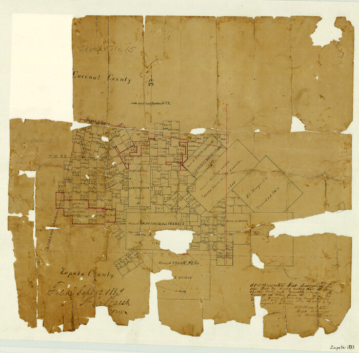
Starr County Sketch File 6

Print $20.00
- Digital $50.00
Starr County Sketch File 6
Size: 43.4 x 36.7 inches
10605
Webb County Sketch File 16

Print $20.00
- Digital $50.00
Webb County Sketch File 16
Size: 37.1 x 24.5 inches
12635
Starr County Sketch File 52

Print $4.00
- Digital $50.00
Starr County Sketch File 52
Size: 13.9 x 9.0 inches
37011
Zapata County Sketch File 16

Print $6.00
- Digital $50.00
Zapata County Sketch File 16
Size: 14.5 x 8.8 inches
40957
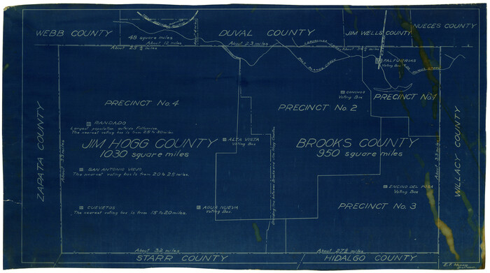
[Sketch showing voting precincts in Jim Hogg and Brooks Counties]
Print $20.00
- Digital $50.00
[Sketch showing voting precincts in Jim Hogg and Brooks Counties]
Size: 10.1 x 18.2 inches
4497
Starr County Sketch File 14

Print $40.00
- Digital $50.00
Starr County Sketch File 14
Size: 23.8 x 46.0 inches
4626
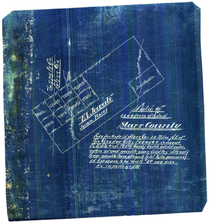
[El Javali Grant,] Sketch of 2560 acres of land in Starr County
Print $20.00
- Digital $50.00
[El Javali Grant,] Sketch of 2560 acres of land in Starr County
Size: 13.4 x 14.0 inches
474
Zapata County Rolled Sketch 21

Print $155.00
- Digital $50.00
Zapata County Rolled Sketch 21
Size: 10.4 x 15.2 inches
49589
Zapata County Rolled Sketch 23

Print $55.00
- Digital $50.00
Zapata County Rolled Sketch 23
Size: 9.6 x 13.0 inches
49630
Zapata County Boundary File 1

Print $2.00
- Digital $50.00
Zapata County Boundary File 1
Size: 11.4 x 9.0 inches
60227
Zapata County Boundary File 2

Print $12.00
- Digital $50.00
Zapata County Boundary File 2
Size: 14.4 x 8.8 inches
60228
Jim Hogg County Rolled Sketch 4

Print $20.00
- Digital $50.00
Jim Hogg County Rolled Sketch 4
Size: 17.0 x 30.5 inches
6440
Starr County Sketch File 5

Print $40.00
- Digital $50.00
Starr County Sketch File 5
Size: 31.4 x 40.7 inches
82571
Zapata County Rolled Sketch 24

Print $20.00
- Digital $50.00
Zapata County Rolled Sketch 24
Size: 38.8 x 28.0 inches
8318
Starr County Rolled Sketch 2

Print $40.00
- Digital $50.00
Starr County Rolled Sketch 2
1853
Size: 31.7 x 48.5 inches
9938
Webb County Sketch File 3a

Print $40.00
- Digital $50.00
Webb County Sketch File 3a
1855
Size: 32.1 x 20.8 inches
12613
Map of Zapata County

Print $20.00
- Digital $50.00
Map of Zapata County
1863
Size: 35.0 x 28.0 inches
4175
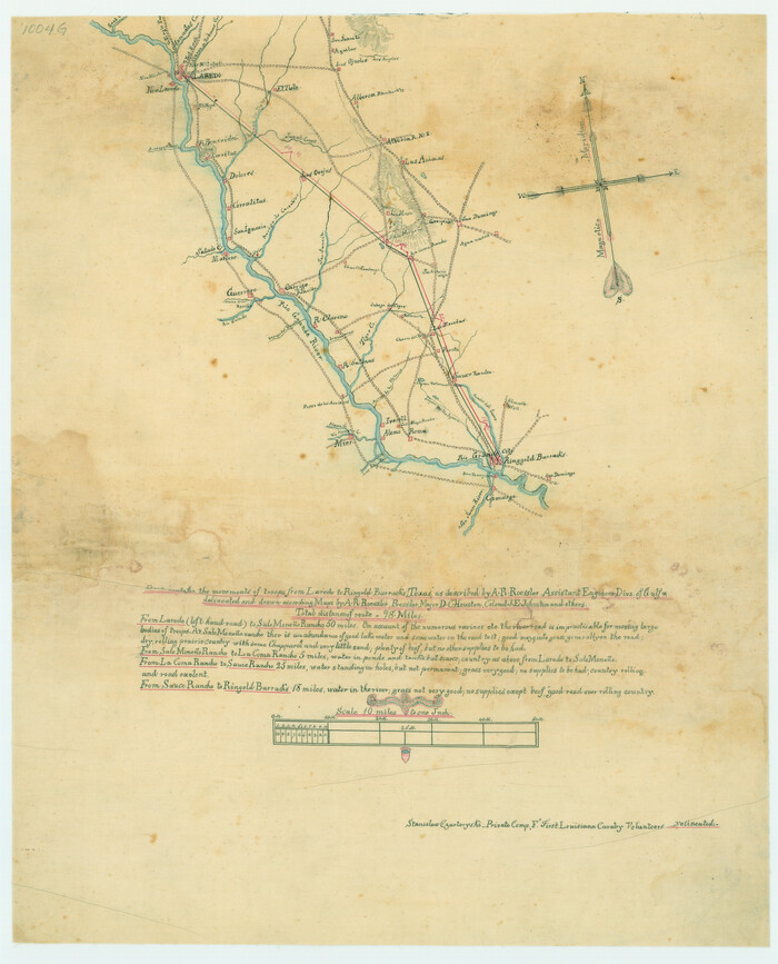
Best Route for Movements of Troops from Laredo to Ringold [sic] Barracks, Texas
Print $20.00
Best Route for Movements of Troops from Laredo to Ringold [sic] Barracks, Texas
1865
Size: 18.9 x 15.3 inches
79299
Map of San Patricio District

Print $40.00
- Digital $50.00
Map of San Patricio District
1870
Size: 43.8 x 51.4 inches
1987
Zapata County Sketch File 1

Print $20.00
- Digital $50.00
Zapata County Sketch File 1
1875
Size: 30.5 x 21.4 inches
12717
Zapata County Sketch File 2

Print $20.00
- Digital $50.00
Zapata County Sketch File 2
1875
Size: 24.3 x 32.8 inches
12718
Map of Zapata County

Print $20.00
- Digital $50.00
Map of Zapata County
1879
Size: 27.4 x 25.6 inches
4176
Starr County Sketch File 17

Print $24.00
- Digital $50.00
Starr County Sketch File 17
1880
Size: 12.8 x 8.2 inches
36874
Starr County Sketch File 18

Print $20.00
- Digital $50.00
Starr County Sketch File 18
1880
Size: 38.2 x 25.1 inches
10606
Map of Zapata County

Print $20.00
- Digital $50.00
Map of Zapata County
1880
Size: 27.1 x 25.7 inches
4177
Zapata County Sketch File 3

Print $6.00
- Digital $50.00
Zapata County Sketch File 3
1883
Size: 16.3 x 10.7 inches
40904
[Map of Zapata County]
Print $20.00
- Digital $50.00
[Map of Zapata County]
1883
Size: 20.5 x 20.9 inches
4178
Zapata County Rolled Sketch 4

Print $20.00
- Digital $50.00
Zapata County Rolled Sketch 4
1884
Size: 15.6 x 13.8 inches
8306
Zapata County Rolled Sketch 25
Print $20.00
- Digital $50.00
Zapata County Rolled Sketch 25
-
Size
45.7 x 37.9 inches
-
Map/Doc
10172
Zapata County Rolled Sketch 28
Print $20.00
- Digital $50.00
Zapata County Rolled Sketch 28
-
Size
35.5 x 35.3 inches
-
Map/Doc
10174
Starr County Sketch File 6
Print $20.00
- Digital $50.00
Starr County Sketch File 6
-
Size
43.4 x 36.7 inches
-
Map/Doc
10605
Webb County Sketch File 16
Print $20.00
- Digital $50.00
Webb County Sketch File 16
-
Size
37.1 x 24.5 inches
-
Map/Doc
12635
Starr County Sketch File 52
Print $4.00
- Digital $50.00
Starr County Sketch File 52
-
Size
13.9 x 9.0 inches
-
Map/Doc
37011
Zapata County Sketch File 16
Print $6.00
- Digital $50.00
Zapata County Sketch File 16
-
Size
14.5 x 8.8 inches
-
Map/Doc
40957
[Sketch showing voting precincts in Jim Hogg and Brooks Counties]
Print $20.00
- Digital $50.00
[Sketch showing voting precincts in Jim Hogg and Brooks Counties]
-
Size
10.1 x 18.2 inches
-
Map/Doc
4497
Starr County Sketch File 14
Print $40.00
- Digital $50.00
Starr County Sketch File 14
-
Size
23.8 x 46.0 inches
-
Map/Doc
4626
[El Javali Grant,] Sketch of 2560 acres of land in Starr County
Print $20.00
- Digital $50.00
[El Javali Grant,] Sketch of 2560 acres of land in Starr County
-
Size
13.4 x 14.0 inches
-
Map/Doc
474
Zapata County Rolled Sketch 21
Print $155.00
- Digital $50.00
Zapata County Rolled Sketch 21
-
Size
10.4 x 15.2 inches
-
Map/Doc
49589
Zapata County Rolled Sketch 23
Print $55.00
- Digital $50.00
Zapata County Rolled Sketch 23
-
Size
9.6 x 13.0 inches
-
Map/Doc
49630
Zapata County Boundary File 1
Print $2.00
- Digital $50.00
Zapata County Boundary File 1
-
Size
11.4 x 9.0 inches
-
Map/Doc
60227
Zapata County Boundary File 2
Print $12.00
- Digital $50.00
Zapata County Boundary File 2
-
Size
14.4 x 8.8 inches
-
Map/Doc
60228
Jim Hogg County Rolled Sketch 4
Print $20.00
- Digital $50.00
Jim Hogg County Rolled Sketch 4
-
Size
17.0 x 30.5 inches
-
Map/Doc
6440
Starr County Sketch File 5
Print $40.00
- Digital $50.00
Starr County Sketch File 5
-
Size
31.4 x 40.7 inches
-
Map/Doc
82571
Zapata County Rolled Sketch 24
Print $20.00
- Digital $50.00
Zapata County Rolled Sketch 24
-
Size
38.8 x 28.0 inches
-
Map/Doc
8318
Starr County Rolled Sketch 2
Print $40.00
- Digital $50.00
Starr County Rolled Sketch 2
1853
-
Size
31.7 x 48.5 inches
-
Map/Doc
9938
-
Creation Date
1853
Webb County Sketch File 3a
Print $40.00
- Digital $50.00
Webb County Sketch File 3a
1855
-
Size
32.1 x 20.8 inches
-
Map/Doc
12613
-
Creation Date
1855
Map of Zapata County
Print $20.00
- Digital $50.00
Map of Zapata County
1863
-
Size
35.0 x 28.0 inches
-
Map/Doc
4175
-
Creation Date
1863
Best Route for Movements of Troops from Laredo to Ringold [sic] Barracks, Texas
Print $20.00
Best Route for Movements of Troops from Laredo to Ringold [sic] Barracks, Texas
1865
-
Size
18.9 x 15.3 inches
-
Map/Doc
79299
-
Creation Date
1865
Map of San Patricio District
Print $40.00
- Digital $50.00
Map of San Patricio District
1870
-
Size
43.8 x 51.4 inches
-
Map/Doc
1987
-
Creation Date
1870
Zapata County Sketch File 1
Print $20.00
- Digital $50.00
Zapata County Sketch File 1
1875
-
Size
30.5 x 21.4 inches
-
Map/Doc
12717
-
Creation Date
1875
Zapata County Sketch File 2
Print $20.00
- Digital $50.00
Zapata County Sketch File 2
1875
-
Size
24.3 x 32.8 inches
-
Map/Doc
12718
-
Creation Date
1875
Map of Zapata County
Print $20.00
- Digital $50.00
Map of Zapata County
1879
-
Size
27.4 x 25.6 inches
-
Map/Doc
4176
-
Creation Date
1879
Starr County Sketch File 17
Print $24.00
- Digital $50.00
Starr County Sketch File 17
1880
-
Size
12.8 x 8.2 inches
-
Map/Doc
36874
-
Creation Date
1880
Starr County Sketch File 18
Print $20.00
- Digital $50.00
Starr County Sketch File 18
1880
-
Size
38.2 x 25.1 inches
-
Map/Doc
10606
-
Creation Date
1880
Map of Zapata County
Print $20.00
- Digital $50.00
Map of Zapata County
1880
-
Size
27.1 x 25.7 inches
-
Map/Doc
4177
-
Creation Date
1880
Zapata County Sketch File 3
Print $6.00
- Digital $50.00
Zapata County Sketch File 3
1883
-
Size
16.3 x 10.7 inches
-
Map/Doc
40904
-
Creation Date
1883
[Map of Zapata County]
Print $20.00
- Digital $50.00
[Map of Zapata County]
1883
-
Size
20.5 x 20.9 inches
-
Map/Doc
4178
-
Creation Date
1883
Zapata County Rolled Sketch 4
Print $20.00
- Digital $50.00
Zapata County Rolled Sketch 4
1884
-
Size
15.6 x 13.8 inches
-
Map/Doc
8306
-
Creation Date
1884