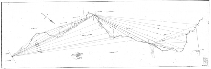
Texas Gulf Coast Map from the Sabine River to the Rio Grande as subdivided for mineral development

Print $40.00
- Digital $50.00
Texas Gulf Coast Map from the Sabine River to the Rio Grande as subdivided for mineral development
Size: 46.0 x 91.3 inches
2901
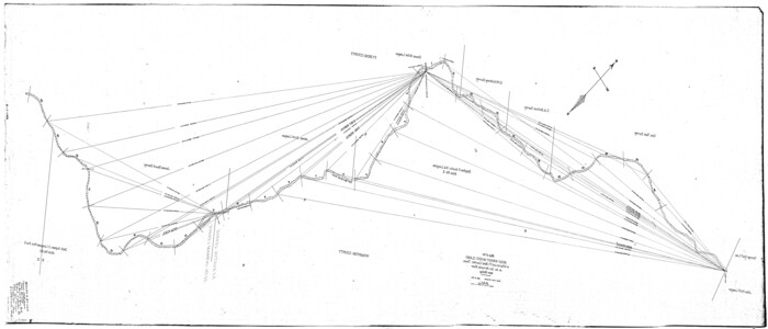
Texas Gulf Coast Map from the Sabine River to the Rio Grande as subdivided for mineral development

Print $40.00
- Digital $50.00
Texas Gulf Coast Map from the Sabine River to the Rio Grande as subdivided for mineral development
Size: 117.9 x 46.0 inches
2902
[Sketch for Mineral Application 21493 - Clay County]
Print $40.00
- Digital $50.00
[Sketch for Mineral Application 21493 - Clay County]
Size: 62.4 x 34.8 inches
65625
[Sketch for Mineral Application 21493 - Clay County]
Print $40.00
- Digital $50.00
[Sketch for Mineral Application 21493 - Clay County]
Size: 63.1 x 35.3 inches
65626
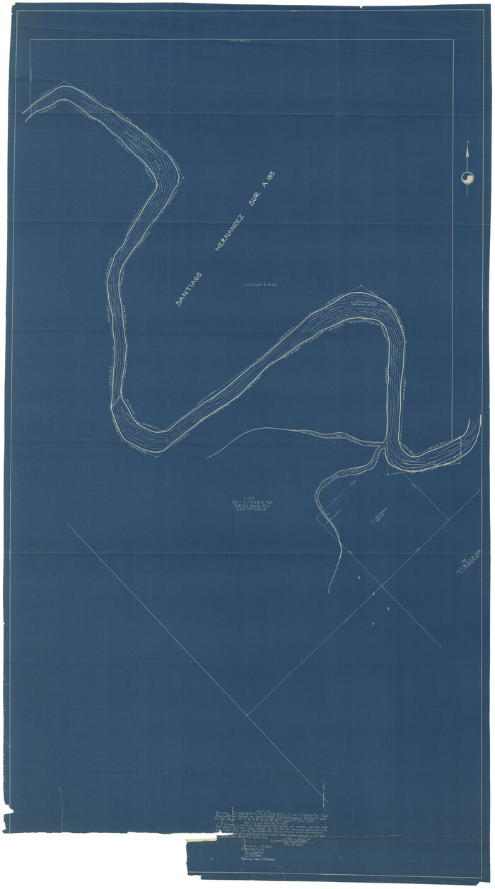
[Sketch for Mineral Application 27670 - Strip between Simon Sanchez leagues and Trinity River]
Print $40.00
- Digital $50.00
[Sketch for Mineral Application 27670 - Strip between Simon Sanchez leagues and Trinity River]
Size: 17.5 x 55.2 inches
65645
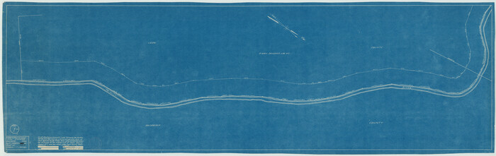
[Sketch for Mineral Application 27670 - Strip between Simon Sanchez leagues and Trinity River]
Print $40.00
- Digital $50.00
[Sketch for Mineral Application 27670 - Strip between Simon Sanchez leagues and Trinity River]
Size: 55.5 x 17.8 inches
65646
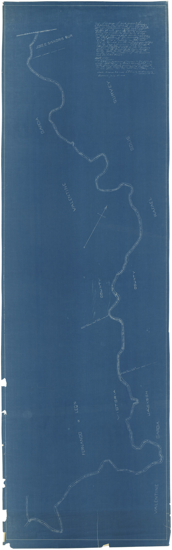
[Sketch for Mineral Application 11318 - Arenosa Creek, S. G. Drushel]
Print $40.00
- Digital $50.00
[Sketch for Mineral Application 11318 - Arenosa Creek, S. G. Drushel]
Size: 78.9 x 24.8 inches
65647
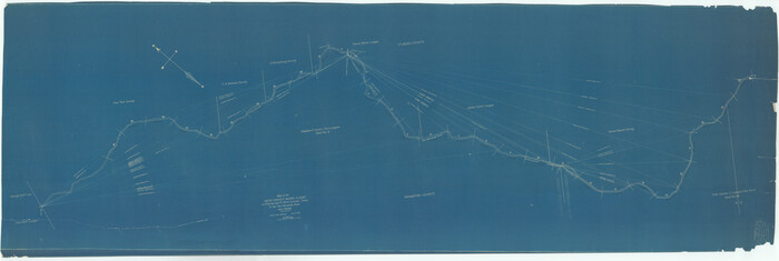
[Sketch for Mineral Application 11318 - Arenosa Creek, S. G. Drushel]
Print $40.00
- Digital $50.00
[Sketch for Mineral Application 11318 - Arenosa Creek, S. G. Drushel]
Size: 79.1 x 25.7 inches
65648
[Sketch for Mineral Application 19560 - 19588 - San Bernard River]
Print $40.00
- Digital $50.00
[Sketch for Mineral Application 19560 - 19588 - San Bernard River]
Size: 32.7 x 97.6 inches
65659
[Sketch for Mineral Application 19560 - 19588 - San Bernard River]
Print $40.00
- Digital $50.00
[Sketch for Mineral Application 19560 - 19588 - San Bernard River]
Size: 98.0 x 33.0 inches
65660
[Sketch for Mineral Application 19560 - 19588 - San Bernard River]
Print $40.00
- Digital $50.00
[Sketch for Mineral Application 19560 - 19588 - San Bernard River]
Size: 32.3 x 98.5 inches
65661
[Sketch for Mineral Application 19560 - 19588 - San Bernard River]
Print $40.00
- Digital $50.00
[Sketch for Mineral Application 19560 - 19588 - San Bernard River]
Size: 31.6 x 73.6 inches
65662
Sketch for Mineral Application 33721 - 33725 Incl (Attorney General) - Map of Padre Island - Cameron, Willacy, Kleberg, Nueces and Kenedy Counties.

Print $20.00
- Digital $50.00
Sketch for Mineral Application 33721 - 33725 Incl (Attorney General) - Map of Padre Island - Cameron, Willacy, Kleberg, Nueces and Kenedy Counties.
Size: 43.3 x 23.1 inches
65663
[Sketch for Mineral Application 33721 - 33725 Incl. - Padre and Mustang Island]
Print $20.00
- Digital $50.00
[Sketch for Mineral Application 33721 - 33725 Incl. - Padre and Mustang Island]
Size: 42.3 x 22.6 inches
65664
Map from the Sabine River to the Rio Grande as subdivided for mineral development

Print $20.00
- Digital $50.00
Map from the Sabine River to the Rio Grande as subdivided for mineral development
Size: 30.6 x 44.8 inches
65801
Map from the Sabine River to the Rio Grande as subdivided for mineral development

Print $40.00
- Digital $50.00
Map from the Sabine River to the Rio Grande as subdivided for mineral development
Size: 43.5 x 72.5 inches
65802
Map of Galveston, Turtle & East Bays & portions of the Gulf of Mexico in Chambers & Galveston Counties, Texas showing subdivision for mineral development

Print $40.00
- Digital $50.00
Map of Galveston, Turtle & East Bays & portions of the Gulf of Mexico in Chambers & Galveston Counties, Texas showing subdivision for mineral development
Size: 48.6 x 56.4 inches
65803
Map of east part of West Bay & SW part of Galveston Bay, Galveston County showing subdivision for mineral development

Print $40.00
- Digital $50.00
Map of east part of West Bay & SW part of Galveston Bay, Galveston County showing subdivision for mineral development
Size: 69.6 x 48.0 inches
65804
Map of Copano, St. Charles, Aransas & Red Fish Bays in Aransas & Nueces Counties showing subdivision thereof for mineral development

Print $40.00
- Digital $50.00
Map of Copano, St. Charles, Aransas & Red Fish Bays in Aransas & Nueces Counties showing subdivision thereof for mineral development
Size: 57.9 x 42.7 inches
65805
Map of Chocolate Bay, west portion of West Bay & vicinity, Brazoria & Galveston Counties showing subdivision for mineral development

Print $40.00
- Digital $50.00
Map of Chocolate Bay, west portion of West Bay & vicinity, Brazoria & Galveston Counties showing subdivision for mineral development
Size: 42.0 x 58.1 inches
65806
Map of Galveston, Turtle & East Bays & portions of the Gulf of Mexico in Chambers & Galveston Counties, Texas showing subdivision for mineral development

Print $40.00
- Digital $50.00
Map of Galveston, Turtle & East Bays & portions of the Gulf of Mexico in Chambers & Galveston Counties, Texas showing subdivision for mineral development
Size: 50.0 x 55.2 inches
65807
Map of Drum, Oyster & Bastrop Bays & vicinity in Brazoria County showing subdivision for mineral development

Print $20.00
- Digital $50.00
Map of Drum, Oyster & Bastrop Bays & vicinity in Brazoria County showing subdivision for mineral development
Size: 36.8 x 47.3 inches
65808
Map of east portion of Matagorda Bay in Matagorda County showing subdivision for mineral development

Print $40.00
- Digital $50.00
Map of east portion of Matagorda Bay in Matagorda County showing subdivision for mineral development
Size: 33.0 x 52.8 inches
65809
Permanent Lakes and Marshes for Mineral Development

Print $20.00
- Digital $50.00
Permanent Lakes and Marshes for Mineral Development
Size: 30.6 x 35.2 inches
73593
Texas Gulf Coast Bay Index Map

Print $20.00
- Digital $50.00
Texas Gulf Coast Bay Index Map
Size: 43.7 x 42.6 inches
73599
Outer Continental Shelf Leasing Maps (Texas Offshore Operations)

Print $20.00
- Digital $50.00
Outer Continental Shelf Leasing Maps (Texas Offshore Operations)
Size: 21.0 x 15.2 inches
75840
Outer Continental Shelf Leasing Maps (Texas Offshore Operations)

Print $20.00
- Digital $50.00
Outer Continental Shelf Leasing Maps (Texas Offshore Operations)
Size: 17.3 x 16.7 inches
75841
Outer Continental Shelf Leasing Maps (Texas Offshore Operations)

Print $20.00
- Digital $50.00
Outer Continental Shelf Leasing Maps (Texas Offshore Operations)
Size: 17.2 x 13.7 inches
75842
Outer Continental Shelf Leasing Maps (Texas Offshore Operations)

Print $20.00
- Digital $50.00
Outer Continental Shelf Leasing Maps (Texas Offshore Operations)
Size: 13.5 x 14.2 inches
75843
[Pecos River Bed]
![2467, [Pecos River Bed], General Map Collection](https://historictexasmaps.com/wmedia_w700/maps/2467.tif.jpg)
Print $20.00
- Digital $50.00
[Pecos River Bed]
-
Size
16.6 x 39.8 inches
-
Map/Doc
2467
Texas Gulf Coast Map from the Sabine River to the Rio Grande as subdivided for mineral development
Print $40.00
- Digital $50.00
Texas Gulf Coast Map from the Sabine River to the Rio Grande as subdivided for mineral development
-
Size
46.0 x 91.3 inches
-
Map/Doc
2901
Texas Gulf Coast Map from the Sabine River to the Rio Grande as subdivided for mineral development
Print $40.00
- Digital $50.00
Texas Gulf Coast Map from the Sabine River to the Rio Grande as subdivided for mineral development
-
Size
117.9 x 46.0 inches
-
Map/Doc
2902
[Sketch for Mineral Application 21493 - Clay County]
Print $40.00
- Digital $50.00
[Sketch for Mineral Application 21493 - Clay County]
-
Size
62.4 x 34.8 inches
-
Map/Doc
65625
[Sketch for Mineral Application 21493 - Clay County]
Print $40.00
- Digital $50.00
[Sketch for Mineral Application 21493 - Clay County]
-
Size
63.1 x 35.3 inches
-
Map/Doc
65626
[Sketch for Mineral Application 27670 - Strip between Simon Sanchez leagues and Trinity River]
Print $40.00
- Digital $50.00
[Sketch for Mineral Application 27670 - Strip between Simon Sanchez leagues and Trinity River]
-
Size
17.5 x 55.2 inches
-
Map/Doc
65645
[Sketch for Mineral Application 27670 - Strip between Simon Sanchez leagues and Trinity River]
Print $40.00
- Digital $50.00
[Sketch for Mineral Application 27670 - Strip between Simon Sanchez leagues and Trinity River]
-
Size
55.5 x 17.8 inches
-
Map/Doc
65646
[Sketch for Mineral Application 11318 - Arenosa Creek, S. G. Drushel]
Print $40.00
- Digital $50.00
[Sketch for Mineral Application 11318 - Arenosa Creek, S. G. Drushel]
-
Size
78.9 x 24.8 inches
-
Map/Doc
65647
[Sketch for Mineral Application 11318 - Arenosa Creek, S. G. Drushel]
Print $40.00
- Digital $50.00
[Sketch for Mineral Application 11318 - Arenosa Creek, S. G. Drushel]
-
Size
79.1 x 25.7 inches
-
Map/Doc
65648
[Sketch for Mineral Application 19560 - 19588 - San Bernard River]
Print $40.00
- Digital $50.00
[Sketch for Mineral Application 19560 - 19588 - San Bernard River]
-
Size
32.7 x 97.6 inches
-
Map/Doc
65659
[Sketch for Mineral Application 19560 - 19588 - San Bernard River]
Print $40.00
- Digital $50.00
[Sketch for Mineral Application 19560 - 19588 - San Bernard River]
-
Size
98.0 x 33.0 inches
-
Map/Doc
65660
[Sketch for Mineral Application 19560 - 19588 - San Bernard River]
Print $40.00
- Digital $50.00
[Sketch for Mineral Application 19560 - 19588 - San Bernard River]
-
Size
32.3 x 98.5 inches
-
Map/Doc
65661
[Sketch for Mineral Application 19560 - 19588 - San Bernard River]
Print $40.00
- Digital $50.00
[Sketch for Mineral Application 19560 - 19588 - San Bernard River]
-
Size
31.6 x 73.6 inches
-
Map/Doc
65662
Sketch for Mineral Application 33721 - 33725 Incl (Attorney General) - Map of Padre Island - Cameron, Willacy, Kleberg, Nueces and Kenedy Counties.
Print $20.00
- Digital $50.00
Sketch for Mineral Application 33721 - 33725 Incl (Attorney General) - Map of Padre Island - Cameron, Willacy, Kleberg, Nueces and Kenedy Counties.
-
Size
43.3 x 23.1 inches
-
Map/Doc
65663
[Sketch for Mineral Application 33721 - 33725 Incl. - Padre and Mustang Island]
Print $20.00
- Digital $50.00
[Sketch for Mineral Application 33721 - 33725 Incl. - Padre and Mustang Island]
-
Size
42.3 x 22.6 inches
-
Map/Doc
65664
Map from the Sabine River to the Rio Grande as subdivided for mineral development
Print $20.00
- Digital $50.00
Map from the Sabine River to the Rio Grande as subdivided for mineral development
-
Size
30.6 x 44.8 inches
-
Map/Doc
65801
Map from the Sabine River to the Rio Grande as subdivided for mineral development
Print $40.00
- Digital $50.00
Map from the Sabine River to the Rio Grande as subdivided for mineral development
-
Size
43.5 x 72.5 inches
-
Map/Doc
65802
Map of Galveston, Turtle & East Bays & portions of the Gulf of Mexico in Chambers & Galveston Counties, Texas showing subdivision for mineral development
Print $40.00
- Digital $50.00
Map of Galveston, Turtle & East Bays & portions of the Gulf of Mexico in Chambers & Galveston Counties, Texas showing subdivision for mineral development
-
Size
48.6 x 56.4 inches
-
Map/Doc
65803
Map of east part of West Bay & SW part of Galveston Bay, Galveston County showing subdivision for mineral development
Print $40.00
- Digital $50.00
Map of east part of West Bay & SW part of Galveston Bay, Galveston County showing subdivision for mineral development
-
Size
69.6 x 48.0 inches
-
Map/Doc
65804
Map of Copano, St. Charles, Aransas & Red Fish Bays in Aransas & Nueces Counties showing subdivision thereof for mineral development
Print $40.00
- Digital $50.00
Map of Copano, St. Charles, Aransas & Red Fish Bays in Aransas & Nueces Counties showing subdivision thereof for mineral development
-
Size
57.9 x 42.7 inches
-
Map/Doc
65805
Map of Chocolate Bay, west portion of West Bay & vicinity, Brazoria & Galveston Counties showing subdivision for mineral development
Print $40.00
- Digital $50.00
Map of Chocolate Bay, west portion of West Bay & vicinity, Brazoria & Galveston Counties showing subdivision for mineral development
-
Size
42.0 x 58.1 inches
-
Map/Doc
65806
Map of Galveston, Turtle & East Bays & portions of the Gulf of Mexico in Chambers & Galveston Counties, Texas showing subdivision for mineral development
Print $40.00
- Digital $50.00
Map of Galveston, Turtle & East Bays & portions of the Gulf of Mexico in Chambers & Galveston Counties, Texas showing subdivision for mineral development
-
Size
50.0 x 55.2 inches
-
Map/Doc
65807
Map of Drum, Oyster & Bastrop Bays & vicinity in Brazoria County showing subdivision for mineral development
Print $20.00
- Digital $50.00
Map of Drum, Oyster & Bastrop Bays & vicinity in Brazoria County showing subdivision for mineral development
-
Size
36.8 x 47.3 inches
-
Map/Doc
65808
Map of east portion of Matagorda Bay in Matagorda County showing subdivision for mineral development
Print $40.00
- Digital $50.00
Map of east portion of Matagorda Bay in Matagorda County showing subdivision for mineral development
-
Size
33.0 x 52.8 inches
-
Map/Doc
65809
Permanent Lakes and Marshes for Mineral Development
Print $20.00
- Digital $50.00
Permanent Lakes and Marshes for Mineral Development
-
Size
30.6 x 35.2 inches
-
Map/Doc
73593
Texas Gulf Coast Bay Index Map
Print $20.00
- Digital $50.00
Texas Gulf Coast Bay Index Map
-
Size
43.7 x 42.6 inches
-
Map/Doc
73599
Outer Continental Shelf Leasing Maps (Texas Offshore Operations)
Print $20.00
- Digital $50.00
Outer Continental Shelf Leasing Maps (Texas Offshore Operations)
-
Size
21.0 x 15.2 inches
-
Map/Doc
75840
Outer Continental Shelf Leasing Maps (Texas Offshore Operations)
Print $20.00
- Digital $50.00
Outer Continental Shelf Leasing Maps (Texas Offshore Operations)
-
Size
17.3 x 16.7 inches
-
Map/Doc
75841
Outer Continental Shelf Leasing Maps (Texas Offshore Operations)
Print $20.00
- Digital $50.00
Outer Continental Shelf Leasing Maps (Texas Offshore Operations)
-
Size
17.2 x 13.7 inches
-
Map/Doc
75842
Outer Continental Shelf Leasing Maps (Texas Offshore Operations)
Print $20.00
- Digital $50.00
Outer Continental Shelf Leasing Maps (Texas Offshore Operations)
-
Size
13.5 x 14.2 inches
-
Map/Doc
75843