"Old Three Hundred" Land Grants under Austin's First Contract


"Old Three Hundred" Land Grants under Austin's First Contract
2023
Size: 8.5 x 11.0 inches
97185
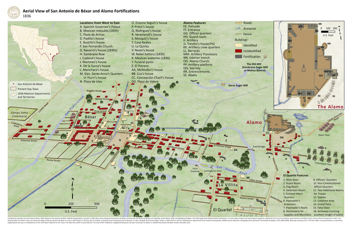
Aerial View of San Antonio de Béxar and Alamo Fortifications


Aerial View of San Antonio de Béxar and Alamo Fortifications
2026
Size: 11.0 x 17.0 inches
97522
American Civil War Political Loyalties


American Civil War Political Loyalties
2022
Size: 8.5 x 11.0 inches
97091
Big Inch and Little Big Inch Pipelines


Big Inch and Little Big Inch Pipelines
2022
Size: 8.5 x 11.0 inches
97089
Contracted Boundaries and Timeline of Mexican Empresario Colonies in Texas


Contracted Boundaries and Timeline of Mexican Empresario Colonies in Texas
2025
Size: 17.0 x 11.0 inches
97439
Disputed Territory Between Mexico and the United States


Disputed Territory Between Mexico and the United States
2023
Size: 11.0 x 8.5 inches
97129
Disputed Territory Between Mexico and the United States


Disputed Territory Between Mexico and the United States
2024
Size: 10.7 x 7.9 inches
97251
Explorations of the Louisiana Purchase


Explorations of the Louisiana Purchase
2023
Size: 8.5 x 11.0 inches
97183
General Range of Indigenous Tribes and Language Families in Texas


General Range of Indigenous Tribes and Language Families in Texas
2022
Size: 8.5 x 11.0 inches
97100
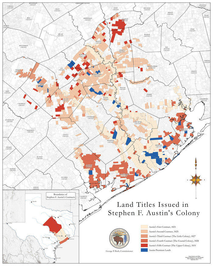
Land Titles Issued in Stephen F. Austin's Colony


Print $20.00
Land Titles Issued in Stephen F. Austin's Colony
2015
Size: 30.0 x 24.0 inches
93754
Map Showing the Distribution of the Slave Population of the Southern States of the United States


Map Showing the Distribution of the Slave Population of the Southern States of the United States
2022
Size: 8.5 x 11.0 inches
96677
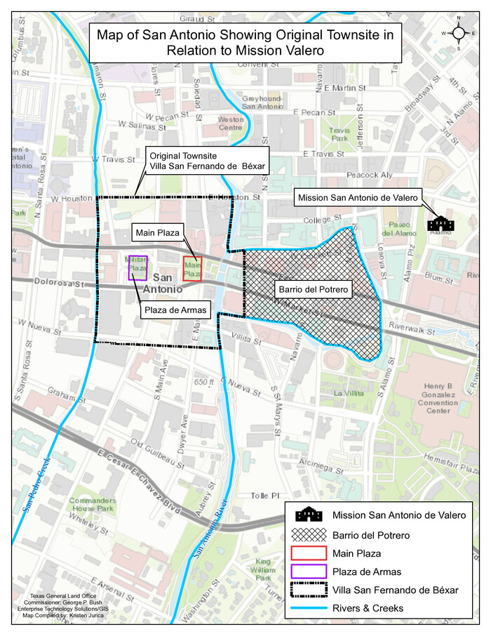
Map of San Antonio Showing Original Townsite in Relation to Mission Valero


Map of San Antonio Showing Original Townsite in Relation to Mission Valero
2017
Size: 11.0 x 8.5 inches
94244
Military Reconstruction Districts


Military Reconstruction Districts
2024
Size: 8.5 x 11.0 inches
97345
North American Territorial Claims and the Treaty of Paris


North American Territorial Claims and the Treaty of Paris
2025
Size: 11.0 x 17.0 inches
97453
Northern Mexico Campaign of the U.S. - Mexico War


Northern Mexico Campaign of the U.S. - Mexico War
2023
Size: 8.5 x 11.0 inches
97152
Primary Transportation Routes through Mexican Texas


Primary Transportation Routes through Mexican Texas
2024
Size: 11.0 x 8.5 inches
97463
Republic of Texas and State of Louisiana Boundary


Republic of Texas and State of Louisiana Boundary
2022
Size: 8.5 x 11.0 inches
96979
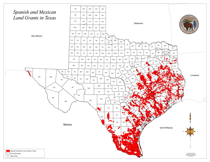
Spanish and Mexican Land Grants in Texas


Print $20.00
Spanish and Mexican Land Grants in Texas
2015
Size: 34.0 x 44.0 inches
93755
"Old Three Hundred" Land Grants under Austin's First Contract


"Old Three Hundred" Land Grants under Austin's First Contract
2023
-
Size
8.5 x 11.0 inches
-
Map/Doc
97185
-
Creation Date
2023
Aerial View of San Antonio de Béxar and Alamo Fortifications


Aerial View of San Antonio de Béxar and Alamo Fortifications
2026
-
Size
11.0 x 17.0 inches
-
Map/Doc
97522
-
Creation Date
2026
American Civil War Political Loyalties


American Civil War Political Loyalties
2022
-
Size
8.5 x 11.0 inches
-
Map/Doc
97091
-
Creation Date
2022
Battle of Cerro Gordo


Battle of Cerro Gordo
2022
-
Size
8.5 x 11.0 inches
-
Map/Doc
97090
-
Creation Date
2022
Big Inch and Little Big Inch Pipelines


Big Inch and Little Big Inch Pipelines
2022
-
Size
8.5 x 11.0 inches
-
Map/Doc
97089
-
Creation Date
2022
Contracted Boundaries and Timeline of Mexican Empresario Colonies in Texas


Contracted Boundaries and Timeline of Mexican Empresario Colonies in Texas
2025
-
Size
17.0 x 11.0 inches
-
Map/Doc
97439
-
Creation Date
2025
Disputed Territory Between Mexico and the United States


Disputed Territory Between Mexico and the United States
2023
-
Size
11.0 x 8.5 inches
-
Map/Doc
97129
-
Creation Date
2023
Disputed Territory Between Mexico and the United States


Disputed Territory Between Mexico and the United States
2024
-
Size
10.7 x 7.9 inches
-
Map/Doc
97251
-
Creation Date
2024
Events of the Texas Revolution


Events of the Texas Revolution
2023
-
Size
8.5 x 11.0 inches
-
Map/Doc
97188
-
Creation Date
2023
Events of the Texas Revolution


Events of the Texas Revolution
2023
-
Size
11.0 x 8.5 inches
-
Map/Doc
97189
-
Creation Date
2023
Events of the Texas Revolution


Events of the Texas Revolution
2023
-
Size
11.0 x 17.0 inches
-
Map/Doc
97194
-
Creation Date
2023
Events of the Texas Revolution


Events of the Texas Revolution
2025
-
Size
8.5 x 11.0 inches
-
Map/Doc
97489
-
Creation Date
2025
Explorations of the Louisiana Purchase


Explorations of the Louisiana Purchase
2023
-
Size
8.5 x 11.0 inches
-
Map/Doc
97183
-
Creation Date
2023
General Range of Indigenous Tribes and Language Families in Texas


General Range of Indigenous Tribes and Language Families in Texas
2022
-
Size
8.5 x 11.0 inches
-
Map/Doc
97100
-
Creation Date
2022
German Immigration to Texas


German Immigration to Texas
2023
-
Size
8.5 x 11.0 inches
-
Map/Doc
97154
-
Creation Date
2023
Kansas-Nebraska Act


Kansas-Nebraska Act
2024
-
Size
8.5 x 11.0 inches
-
Map/Doc
97359
-
Creation Date
2024
Land Titles Issued in Stephen F. Austin's Colony


Print $20.00
Land Titles Issued in Stephen F. Austin's Colony
2015
-
Size
30.0 x 24.0 inches
-
Map/Doc
93754
-
Creation Date
2015
Map Showing the Distribution of the Slave Population of the Southern States of the United States


Map Showing the Distribution of the Slave Population of the Southern States of the United States
2022
-
Size
8.5 x 11.0 inches
-
Map/Doc
96677
-
Creation Date
2022
Map of San Antonio Showing Original Townsite in Relation to Mission Valero


Map of San Antonio Showing Original Townsite in Relation to Mission Valero
2017
-
Size
11.0 x 8.5 inches
-
Map/Doc
94244
-
Creation Date
2017
Military Reconstruction Districts


Military Reconstruction Districts
2024
-
Size
8.5 x 11.0 inches
-
Map/Doc
97345
-
Creation Date
2024
Missouri Compromise of 1820


Missouri Compromise of 1820
2024
-
Size
8.5 x 11.0 inches
-
Map/Doc
97357
-
Creation Date
2024
New Mexico and Adjacent Lands


New Mexico and Adjacent Lands
2022
-
Size
8.5 x 11.0 inches
-
Map/Doc
96977
-
Creation Date
2022
North American Territorial Claims and the Treaty of Paris


North American Territorial Claims and the Treaty of Paris
2025
-
Size
11.0 x 17.0 inches
-
Map/Doc
97453
-
Creation Date
2025
Northern Mexico Campaign of the U.S. - Mexico War


Northern Mexico Campaign of the U.S. - Mexico War
2023
-
Size
8.5 x 11.0 inches
-
Map/Doc
97152
-
Creation Date
2023
Primary Transportation Routes through Mexican Texas


Primary Transportation Routes through Mexican Texas
2024
-
Size
11.0 x 8.5 inches
-
Map/Doc
97463
-
Creation Date
2024
Republic of Texas and State of Louisiana Boundary


Republic of Texas and State of Louisiana Boundary
2022
-
Size
8.5 x 11.0 inches
-
Map/Doc
96979
-
Creation Date
2022
Spanish and Mexican Land Grants in Texas


Print $20.00
Spanish and Mexican Land Grants in Texas
2015
-
Size
34.0 x 44.0 inches
-
Map/Doc
93755
-
Creation Date
2015


