Natural Heritage of Texas

Print $40.00
- Digital $50.00
Natural Heritage of Texas
1986
Size: 54.3 x 56.0 inches
10786
Hoffman & Walker's Pictorial, Historical Map of Texas

Hoffman & Walker's Pictorial, Historical Map of Texas
1960
Size: 44.0 x 45.5 inches
2122
Padre Island Under Six Flags

Print $40.00
- Digital $50.00
Padre Island Under Six Flags
1962
Size: 59.3 x 30.3 inches
3123
Padre Island Under Six Flags

Print $40.00
- Digital $50.00
Padre Island Under Six Flags
1962
Size: 63.7 x 36.9 inches
3126
Partial View of Austin, Texas

Print $20.00
Partial View of Austin, Texas
1895
Size: 28.4 x 41.8 inches
76205
Texas 1849: A Lone Star Rising

Print $20.00
- Digital $50.00
Texas 1849: A Lone Star Rising
2000
Size: 40.6 x 40.7 inches
78270
Corpus Christi is the Sportsman's Paradise

Print $20.00
Corpus Christi is the Sportsman's Paradise
1942
Size: 26.7 x 16.3 inches
79324
Corpus Christi is the Sportsman's Paradise

Print $20.00
Corpus Christi is the Sportsman's Paradise
1942
Size: 26.8 x 16.4 inches
79331
Greenville, Hunt County, Texas

Print $20.00
Greenville, Hunt County, Texas
1891
Size: 21.9 x 36.5 inches
79749
Texas Land Commissioner Jerry Patterson's Great Military Map of Texas showing Significant Conflicts and Events between 1685 and 1916

Print $20.00
- Digital $50.00
Texas Land Commissioner Jerry Patterson's Great Military Map of Texas showing Significant Conflicts and Events between 1685 and 1916
2006
Size: 36.7 x 24.8 inches
83432
170th Anniversary Land Commissioners of the Texas General Land Office

Print $20.00
- Digital $50.00
170th Anniversary Land Commissioners of the Texas General Land Office
2006
Size: 36.4 x 24.1 inches
87177
Revolutionary Map of Texas, 1836

Print $27.06
Revolutionary Map of Texas, 1836
1986
Size: 32.7 x 26.7 inches
89022
Commemorative Map of the Republic of Texas, 1845

Print $27.06
Commemorative Map of the Republic of Texas, 1845
1986
Size: 32.7 x 26.7 inches
89023
West and Trans-Pecos Texas with parts of New Mexico and Mexico and a New Map of Big Bend Ranch State Park and Surrounding Area

Print $32.48
West and Trans-Pecos Texas with parts of New Mexico and Mexico and a New Map of Big Bend Ranch State Park and Surrounding Area
1988
Size: 28.0 x 31.0 inches
89070
Bird's Eye View of Abilene, Taylor County, Texas

Print $20.00
Bird's Eye View of Abilene, Taylor County, Texas
1883
Size: 23.6 x 30.7 inches
89071
Bird's Eye View of Bastrop, Bastrop County, Texas

Print $20.00
Bird's Eye View of Bastrop, Bastrop County, Texas
1887
Size: 18.8 x 25.7 inches
89073
Bird's Eye View of the City of Belton, Bell County, Texas

Print $20.00
Bird's Eye View of the City of Belton, Bell County, Texas
1881
Size: 18.5 x 23.8 inches
89074
Bird's Eye View of Brenham, Washington County, Texas

Print $20.00
Bird's Eye View of Brenham, Washington County, Texas
1873
Size: 20.0 x 25.7 inches
89075
Bird's Eye View of the City of Brenham, Washington County, Texas

Print $20.00
Bird's Eye View of the City of Brenham, Washington County, Texas
1881
Size: 19.4 x 26.7 inches
89076
Clarendon, Texas, Donley Co.

Print $20.00
Clarendon, Texas, Donley Co.
1890
Size: 15.7 x 26.6 inches
89078
Bird's Eye View of Cuero, De Witt County, Texas

Print $20.00
Bird's Eye View of Cuero, De Witt County, Texas
1881
Size: 18.4 x 25.5 inches
89079
Bird's Eye View of the City of Dallas, Texas

Print $20.00
Bird's Eye View of the City of Dallas, Texas
1872
Size: 18.6 x 25.6 inches
89080
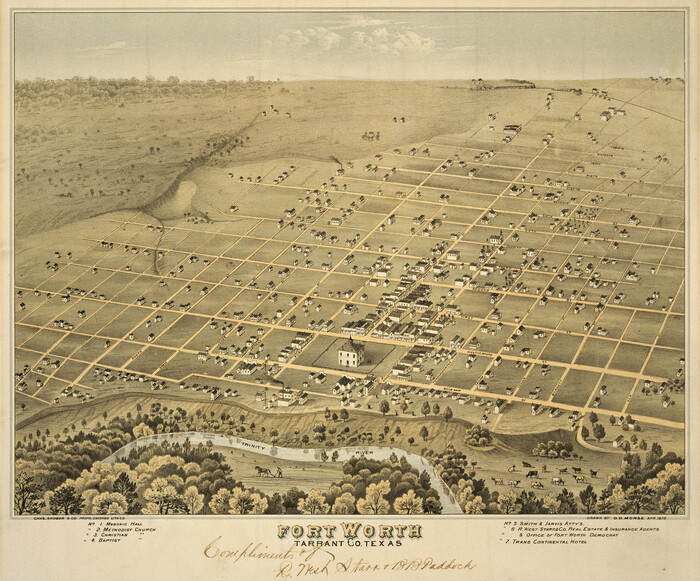
Fort Worth, Tarrant Co[unty], Texas
Print $20.00
Fort Worth, Tarrant Co[unty], Texas
1876
Size: 14.9 x 18.0 inches
89081
Fort Worth, Tex. "The Queen of the Prairies," County Seat of Tarrant County

Print $20.00
Fort Worth, Tex. "The Queen of the Prairies," County Seat of Tarrant County
1886
Size: 26.0 x 33.3 inches
89082
Perspective Map of Fort Worth, Tex.

Print $20.00
Perspective Map of Fort Worth, Tex.
1891
Size: 19.9 x 33.0 inches
89083
Bird's Eye View of the City of Gainesville Cooke County, Texas

Print $20.00
Bird's Eye View of the City of Gainesville Cooke County, Texas
1883
Size: 19.2 x 25.6 inches
89084
Bird's Eye View of the City of Galveston Texas

Print $20.00
Bird's Eye View of the City of Galveston Texas
1871
Size: 20.4 x 30.8 inches
89086
Natural Heritage of Texas
Print $40.00
- Digital $50.00
Natural Heritage of Texas
1986
-
Size
54.3 x 56.0 inches
-
Map/Doc
10786
-
Creation Date
1986
Hoffman & Walker's Pictorial, Historical Map of Texas
Hoffman & Walker's Pictorial, Historical Map of Texas
1960
-
Size
44.0 x 45.5 inches
-
Map/Doc
2122
-
Creation Date
1960
Padre Island Under Six Flags
Print $40.00
- Digital $50.00
Padre Island Under Six Flags
1962
-
Size
59.3 x 30.3 inches
-
Map/Doc
3123
-
Creation Date
1962
Padre Island Under Six Flags
Print $40.00
- Digital $50.00
Padre Island Under Six Flags
1962
-
Size
63.7 x 36.9 inches
-
Map/Doc
3126
-
Creation Date
1962
Partial View of Austin, Texas
Print $20.00
Partial View of Austin, Texas
1895
-
Size
28.4 x 41.8 inches
-
Map/Doc
76205
-
Creation Date
1895
Map of Hyde Park

Print $20.00
- Digital $50.00
Map of Hyde Park
1895
-
Size
41.7 x 28.8 inches
-
Map/Doc
76206
-
Creation Date
1895
Texas 1849: A Lone Star Rising
Print $20.00
- Digital $50.00
Texas 1849: A Lone Star Rising
2000
-
Size
40.6 x 40.7 inches
-
Map/Doc
78270
-
Creation Date
2000
Corpus Christi is the Sportsman's Paradise
Print $20.00
Corpus Christi is the Sportsman's Paradise
1942
-
Size
26.7 x 16.3 inches
-
Map/Doc
79324
-
Creation Date
1942
Corpus Christi is the Sportsman's Paradise
Print $20.00
Corpus Christi is the Sportsman's Paradise
1942
-
Size
26.8 x 16.4 inches
-
Map/Doc
79331
-
Creation Date
1942
Greenville, Hunt County, Texas
Print $20.00
Greenville, Hunt County, Texas
1891
-
Size
21.9 x 36.5 inches
-
Map/Doc
79749
-
Creation Date
1891
Texas Land Commissioner Jerry Patterson's Great Military Map of Texas showing Significant Conflicts and Events between 1685 and 1916
Print $20.00
- Digital $50.00
Texas Land Commissioner Jerry Patterson's Great Military Map of Texas showing Significant Conflicts and Events between 1685 and 1916
2006
-
Size
36.7 x 24.8 inches
-
Map/Doc
83432
-
Creation Date
2006
170th Anniversary Land Commissioners of the Texas General Land Office
Print $20.00
- Digital $50.00
170th Anniversary Land Commissioners of the Texas General Land Office
2006
-
Size
36.4 x 24.1 inches
-
Map/Doc
87177
-
Creation Date
2006
Revolutionary Map of Texas, 1836
Print $27.06
Revolutionary Map of Texas, 1836
1986
-
Size
32.7 x 26.7 inches
-
Map/Doc
89022
-
Creation Date
1986
Commemorative Map of the Republic of Texas, 1845
Print $27.06
Commemorative Map of the Republic of Texas, 1845
1986
-
Size
32.7 x 26.7 inches
-
Map/Doc
89023
-
Creation Date
1986
West and Trans-Pecos Texas with parts of New Mexico and Mexico and a New Map of Big Bend Ranch State Park and Surrounding Area
Print $32.48
West and Trans-Pecos Texas with parts of New Mexico and Mexico and a New Map of Big Bend Ranch State Park and Surrounding Area
1988
-
Size
28.0 x 31.0 inches
-
Map/Doc
89070
-
Creation Date
1988
Bird's Eye View of Abilene, Taylor County, Texas
Print $20.00
Bird's Eye View of Abilene, Taylor County, Texas
1883
-
Size
23.6 x 30.7 inches
-
Map/Doc
89071
-
Creation Date
1883
Alvord, Texas

Print $20.00
Alvord, Texas
1890
-
Size
12.6 x 19.3 inches
-
Map/Doc
89072
-
Creation Date
1890
Bird's Eye View of Bastrop, Bastrop County, Texas
Print $20.00
Bird's Eye View of Bastrop, Bastrop County, Texas
1887
-
Size
18.8 x 25.7 inches
-
Map/Doc
89073
-
Creation Date
1887
Bird's Eye View of the City of Belton, Bell County, Texas
Print $20.00
Bird's Eye View of the City of Belton, Bell County, Texas
1881
-
Size
18.5 x 23.8 inches
-
Map/Doc
89074
-
Creation Date
1881
Bird's Eye View of Brenham, Washington County, Texas
Print $20.00
Bird's Eye View of Brenham, Washington County, Texas
1873
-
Size
20.0 x 25.7 inches
-
Map/Doc
89075
-
Creation Date
1873
Bird's Eye View of the City of Brenham, Washington County, Texas
Print $20.00
Bird's Eye View of the City of Brenham, Washington County, Texas
1881
-
Size
19.4 x 26.7 inches
-
Map/Doc
89076
-
Creation Date
1881
Childress, Texas

Print $20.00
Childress, Texas
1890
-
Size
12.3 x 17.9 inches
-
Map/Doc
89077
-
Creation Date
1890
Clarendon, Texas, Donley Co.
Print $20.00
Clarendon, Texas, Donley Co.
1890
-
Size
15.7 x 26.6 inches
-
Map/Doc
89078
-
Creation Date
1890
Bird's Eye View of Cuero, De Witt County, Texas
Print $20.00
Bird's Eye View of Cuero, De Witt County, Texas
1881
-
Size
18.4 x 25.5 inches
-
Map/Doc
89079
-
Creation Date
1881
Bird's Eye View of the City of Dallas, Texas
Print $20.00
Bird's Eye View of the City of Dallas, Texas
1872
-
Size
18.6 x 25.6 inches
-
Map/Doc
89080
-
Creation Date
1872
Fort Worth, Tarrant Co[unty], Texas
Print $20.00
Fort Worth, Tarrant Co[unty], Texas
1876
-
Size
14.9 x 18.0 inches
-
Map/Doc
89081
-
Creation Date
1876
Fort Worth, Tex. "The Queen of the Prairies," County Seat of Tarrant County
Print $20.00
Fort Worth, Tex. "The Queen of the Prairies," County Seat of Tarrant County
1886
-
Size
26.0 x 33.3 inches
-
Map/Doc
89082
-
Creation Date
1886
Perspective Map of Fort Worth, Tex.
Print $20.00
Perspective Map of Fort Worth, Tex.
1891
-
Size
19.9 x 33.0 inches
-
Map/Doc
89083
-
Creation Date
1891
Bird's Eye View of the City of Gainesville Cooke County, Texas
Print $20.00
Bird's Eye View of the City of Gainesville Cooke County, Texas
1883
-
Size
19.2 x 25.6 inches
-
Map/Doc
89084
-
Creation Date
1883
Bird's Eye View of the City of Galveston Texas
Print $20.00
Bird's Eye View of the City of Galveston Texas
1871
-
Size
20.4 x 30.8 inches
-
Map/Doc
89086
-
Creation Date
1871