University Land Field Note Volume Index

University Land Field Note Volume Index
2023
Size: 8.5 x 11.0 inches
97177
Map of University Land being a part of Block L, El Paso County, Texas

Print $20.00
- Digital $50.00
Map of University Land being a part of Block L, El Paso County, Texas
1945
Size: 26.1 x 25.8 inches
2423
University Land Block 46, Culberson County, Texas

Print $20.00
- Digital $50.00
University Land Block 46, Culberson County, Texas
1938
Size: 35.1 x 22.0 inches
2410
University Land, Block 48, Culberson County, Texas

Print $20.00
- Digital $50.00
University Land, Block 48, Culberson County, Texas
1938
Size: 28.1 x 21.7 inches
2411
[University Land in Loving, Ward, Winkler, Pecos, Crane, Ector, Upton, Crockett, Schleicher, Irion and Reagan Counties]
Print $40.00
- Digital $50.00
[University Land in Loving, Ward, Winkler, Pecos, Crane, Ector, Upton, Crockett, Schleicher, Irion and Reagan Counties]
1938
Size: 37.9 x 78.5 inches
2424
University Land, Pecos County, Texas

Print $20.00
- Digital $50.00
University Land, Pecos County, Texas
1932
Size: 35.7 x 47.5 inches
2433
[Sketch for Mineral Applications 26885-6 - Reagan and Crockett Cos., W. H. Bland]
Print $20.00
- Digital $50.00
[Sketch for Mineral Applications 26885-6 - Reagan and Crockett Cos., W. H. Bland]
1932
Size: 38.4 x 9.7 inches
3219
University Land Loving-Ward-Winkler Counties

Print $40.00
- Digital $50.00
University Land Loving-Ward-Winkler Counties
1931
Size: 47.9 x 63.2 inches
2415
University Land, Winkler-Andrews-Gaines-Dawson-Martin Counties

Print $40.00
- Digital $50.00
University Land, Winkler-Andrews-Gaines-Dawson-Martin Counties
1931
Size: 42.3 x 52.1 inches
2419
University Land Loving-Ward-Winkler Counties

Print $20.00
- Digital $50.00
University Land Loving-Ward-Winkler Counties
1931
Size: 24.7 x 33.2 inches
2448
Map of State University Land, Pecos County, Texas

Print $20.00
- Digital $50.00
Map of State University Land, Pecos County, Texas
1929
Size: 42.1 x 33.5 inches
91626
Map of State University Land, Pecos County, Texas

Print $20.00
- Digital $50.00
Map of State University Land, Pecos County, Texas
1929
Size: 28.4 x 22.7 inches
91631
Sketch in Crockett County [showing University Land Blocks 46-51]
Print $20.00
- Digital $50.00
Sketch in Crockett County [showing University Land Blocks 46-51]
1915
Size: 10.6 x 20.1 inches
90312
Sketch in Crockett County [showing University Land Blocks 42 and 45 and Block A-B]
Print $20.00
- Digital $50.00
Sketch in Crockett County [showing University Land Blocks 42 and 45 and Block A-B]
1913
Size: 24.6 x 11.9 inches
90313
[University Lands Block 16 and Blocks 194, Z and part of 12]
Print $20.00
- Digital $50.00
[University Lands Block 16 and Blocks 194, Z and part of 12]
1911
Size: 32.2 x 23.3 inches
91618
[Part of Blocks H. & G. N. 12, University Lands 16 and 17, C-3, C-4, A-2, 194 and Z]
Print $20.00
- Digital $50.00
[Part of Blocks H. & G. N. 12, University Lands 16 and 17, C-3, C-4, A-2, 194 and Z]
1907
Size: 26.1 x 18.9 inches
91621
University Land in Cooke County

Print $20.00
- Digital $50.00
University Land in Cooke County
1906
Size: 23.6 x 30.0 inches
2425
University Land, Lamar County

Print $20.00
- Digital $50.00
University Land, Lamar County
1906
Size: 23.8 x 29.9 inches
2431
University Land, El Paso County

Print $20.00
- Digital $50.00
University Land, El Paso County
1906
Size: 25.1 x 31.4 inches
2428
Map of University Land part of Fifty League Grant Act of 1839

Print $20.00
- Digital $50.00
Map of University Land part of Fifty League Grant Act of 1839
1905
Size: 40.7 x 28.7 inches
2430
Map of University Land in McLennan County

Print $20.00
- Digital $50.00
Map of University Land in McLennan County
1905
Size: 35.1 x 32.9 inches
2432
Map of University Land in Shackelford and Callahan Counties

Print $20.00
- Digital $50.00
Map of University Land in Shackelford and Callahan Counties
1905
Size: 33.4 x 25.3 inches
2435
Old Miscellaneous File 11

Print $4.00
- Digital $50.00
Old Miscellaneous File 11
1886
Size: 11.2 x 8.8 inches
75437
Survey of 77 Blocks, State University Land

Survey of 77 Blocks, State University Land
1884
Size: 13.5 x 8.5 inches
81693
Old Miscellaneous File 38

Print $40.00
- Digital $50.00
Old Miscellaneous File 38
1841
Size: 57.8 x 33.9 inches
75282
University Land in Hudspeth County showing Mineral Surveys in Blocks A, B, C, D, E, F, G, H, I, J, K, L, M, N

Print $40.00
- Digital $50.00
University Land in Hudspeth County showing Mineral Surveys in Blocks A, B, C, D, E, F, G, H, I, J, K, L, M, N
Size: 39.7 x 48.4 inches
2421
University Land in Grayson County in Two Parts

Print $20.00
- Digital $50.00
University Land in Grayson County in Two Parts
Size: 23.9 x 30.4 inches
2429
University Land, Winkler-Andrews-Gaines-Dawson-Martin Counties

Print $40.00
- Digital $50.00
University Land, Winkler-Andrews-Gaines-Dawson-Martin Counties
Size: 42.8 x 53.2 inches
62931
University of Texas Land Survey Isogonic Chart and Graph of Meridian Changes on University Lands Principally in Andrews County, Texas

Print $20.00
- Digital $50.00
University of Texas Land Survey Isogonic Chart and Graph of Meridian Changes on University Lands Principally in Andrews County, Texas
Size: 15.0 x 18.4 inches
62947
Isogonic Chart and Meridian Changes, University Land, Hudspeth County, Texas

Print $20.00
- Digital $50.00
Isogonic Chart and Meridian Changes, University Land, Hudspeth County, Texas
Size: 28.5 x 34.1 inches
62953
University Land Field Note Volume Index
University Land Field Note Volume Index
2023
This index was created to help users determine which University Land field note volume to view....
-
Size
8.5 x 11.0 inches
-
Map/Doc
97177
-
Creation Date
2023
Map of University Land being a part of Block L, El Paso County, Texas
Print $20.00
- Digital $50.00
Map of University Land being a part of Block L, El Paso County, Texas
1945
-
Size
26.1 x 25.8 inches
-
Map/Doc
2423
-
Creation Date
1945
University Land Block 46, Culberson County, Texas
Print $20.00
- Digital $50.00
University Land Block 46, Culberson County, Texas
1938
-
Size
35.1 x 22.0 inches
-
Map/Doc
2410
-
Creation Date
1938
University Land, Block 48, Culberson County, Texas
Print $20.00
- Digital $50.00
University Land, Block 48, Culberson County, Texas
1938
-
Size
28.1 x 21.7 inches
-
Map/Doc
2411
-
Creation Date
1938
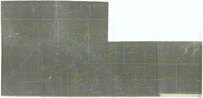
[University Land in Loving, Ward, Winkler, Pecos, Crane, Ector, Upton, Crockett, Schleicher, Irion and Reagan Counties]
Print $40.00
- Digital $50.00
[University Land in Loving, Ward, Winkler, Pecos, Crane, Ector, Upton, Crockett, Schleicher, Irion and Reagan Counties]
1938
-
Size
37.9 x 78.5 inches
-
Map/Doc
2424
-
Creation Date
1938
University Land, Pecos County, Texas
Print $20.00
- Digital $50.00
University Land, Pecos County, Texas
1932
-
Size
35.7 x 47.5 inches
-
Map/Doc
2433
-
Creation Date
1932
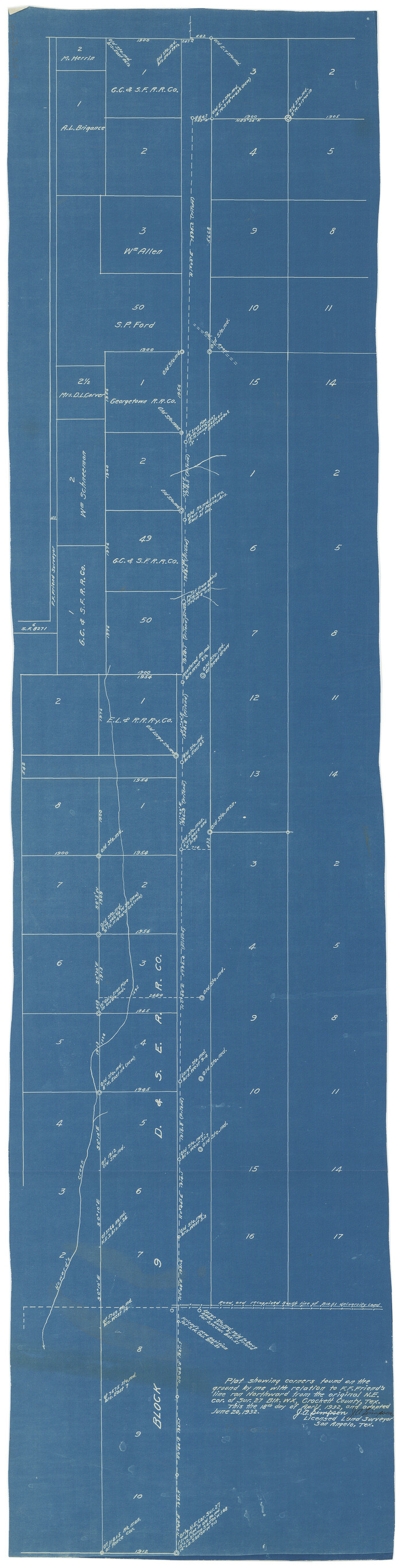
[Sketch for Mineral Applications 26885-6 - Reagan and Crockett Cos., W. H. Bland]
Print $20.00
- Digital $50.00
[Sketch for Mineral Applications 26885-6 - Reagan and Crockett Cos., W. H. Bland]
1932
-
Size
38.4 x 9.7 inches
-
Map/Doc
3219
-
Creation Date
1932
University Land Loving-Ward-Winkler Counties
Print $40.00
- Digital $50.00
University Land Loving-Ward-Winkler Counties
1931
-
Size
47.9 x 63.2 inches
-
Map/Doc
2415
-
Creation Date
1931
University Land, Winkler-Andrews-Gaines-Dawson-Martin Counties
Print $40.00
- Digital $50.00
University Land, Winkler-Andrews-Gaines-Dawson-Martin Counties
1931
-
Size
42.3 x 52.1 inches
-
Map/Doc
2419
-
Creation Date
1931
University Land Loving-Ward-Winkler Counties
Print $20.00
- Digital $50.00
University Land Loving-Ward-Winkler Counties
1931
-
Size
24.7 x 33.2 inches
-
Map/Doc
2448
-
Creation Date
1931
Map of State University Land, Pecos County, Texas
Print $20.00
- Digital $50.00
Map of State University Land, Pecos County, Texas
1929
-
Size
42.1 x 33.5 inches
-
Map/Doc
91626
-
Creation Date
1929
Map of State University Land, Pecos County, Texas
Print $20.00
- Digital $50.00
Map of State University Land, Pecos County, Texas
1929
-
Size
28.4 x 22.7 inches
-
Map/Doc
91631
-
Creation Date
1929
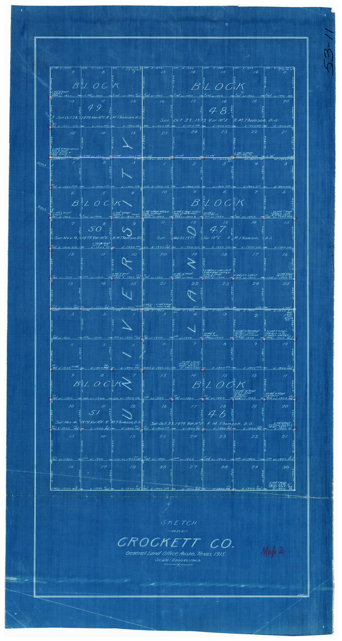
Sketch in Crockett County [showing University Land Blocks 46-51]
Print $20.00
- Digital $50.00
Sketch in Crockett County [showing University Land Blocks 46-51]
1915
-
Size
10.6 x 20.1 inches
-
Map/Doc
90312
-
Creation Date
1915
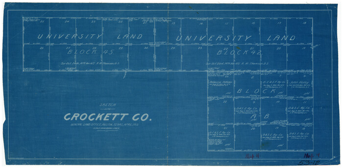
Sketch in Crockett County [showing University Land Blocks 42 and 45 and Block A-B]
Print $20.00
- Digital $50.00
Sketch in Crockett County [showing University Land Blocks 42 and 45 and Block A-B]
1913
-
Size
24.6 x 11.9 inches
-
Map/Doc
90313
-
Creation Date
1913
[University Lands Block 16 and Blocks 194, Z and part of 12]
Print $20.00
- Digital $50.00
[University Lands Block 16 and Blocks 194, Z and part of 12]
1911
-
Size
32.2 x 23.3 inches
-
Map/Doc
91618
-
Creation Date
1911
[Part of Blocks H. & G. N. 12, University Lands 16 and 17, C-3, C-4, A-2, 194 and Z]
Print $20.00
- Digital $50.00
[Part of Blocks H. & G. N. 12, University Lands 16 and 17, C-3, C-4, A-2, 194 and Z]
1907
-
Size
26.1 x 18.9 inches
-
Map/Doc
91621
-
Creation Date
1907
University Land in Cooke County
Print $20.00
- Digital $50.00
University Land in Cooke County
1906
-
Size
23.6 x 30.0 inches
-
Map/Doc
2425
-
Creation Date
1906
University Land, Lamar County
Print $20.00
- Digital $50.00
University Land, Lamar County
1906
-
Size
23.8 x 29.9 inches
-
Map/Doc
2431
-
Creation Date
1906
University Land, El Paso County
Print $20.00
- Digital $50.00
University Land, El Paso County
1906
-
Size
25.1 x 31.4 inches
-
Map/Doc
2428
-
Creation Date
1906
Map of University Land part of Fifty League Grant Act of 1839
Print $20.00
- Digital $50.00
Map of University Land part of Fifty League Grant Act of 1839
1905
-
Size
40.7 x 28.7 inches
-
Map/Doc
2430
-
Creation Date
1905
Map of University Land in McLennan County
Print $20.00
- Digital $50.00
Map of University Land in McLennan County
1905
-
Size
35.1 x 32.9 inches
-
Map/Doc
2432
-
Creation Date
1905
Map of University Land in Shackelford and Callahan Counties
Print $20.00
- Digital $50.00
Map of University Land in Shackelford and Callahan Counties
1905
-
Size
33.4 x 25.3 inches
-
Map/Doc
2435
-
Creation Date
1905
Old Miscellaneous File 11
Print $4.00
- Digital $50.00
Old Miscellaneous File 11
1886
-
Size
11.2 x 8.8 inches
-
Map/Doc
75437
-
Creation Date
1886
Survey of 77 Blocks, State University Land
Survey of 77 Blocks, State University Land
1884
-
Size
13.5 x 8.5 inches
-
Map/Doc
81693
-
Creation Date
1884
Old Miscellaneous File 38
Print $40.00
- Digital $50.00
Old Miscellaneous File 38
1841
-
Size
57.8 x 33.9 inches
-
Map/Doc
75282
-
Creation Date
1841
University Land in Hudspeth County showing Mineral Surveys in Blocks A, B, C, D, E, F, G, H, I, J, K, L, M, N
Print $40.00
- Digital $50.00
University Land in Hudspeth County showing Mineral Surveys in Blocks A, B, C, D, E, F, G, H, I, J, K, L, M, N
-
Size
39.7 x 48.4 inches
-
Map/Doc
2421
University Land in Grayson County in Two Parts
Print $20.00
- Digital $50.00
University Land in Grayson County in Two Parts
-
Size
23.9 x 30.4 inches
-
Map/Doc
2429
University Land, Winkler-Andrews-Gaines-Dawson-Martin Counties
Print $40.00
- Digital $50.00
University Land, Winkler-Andrews-Gaines-Dawson-Martin Counties
-
Size
42.8 x 53.2 inches
-
Map/Doc
62931
University of Texas Land Survey Isogonic Chart and Graph of Meridian Changes on University Lands Principally in Andrews County, Texas
Print $20.00
- Digital $50.00
University of Texas Land Survey Isogonic Chart and Graph of Meridian Changes on University Lands Principally in Andrews County, Texas
-
Size
15.0 x 18.4 inches
-
Map/Doc
62947
Isogonic Chart and Meridian Changes, University Land, Hudspeth County, Texas
Print $20.00
- Digital $50.00
Isogonic Chart and Meridian Changes, University Land, Hudspeth County, Texas
-
Size
28.5 x 34.1 inches
-
Map/Doc
62953