de Leon Empresario Colony. April 30, 1829

Print $20.00
de Leon Empresario Colony. April 30, 1829
2020
Size: 18.5 x 21.7 inches
95990
de Leon Empresario Colony. April 15, 1824

Print $20.00
de Leon Empresario Colony. April 15, 1824
2020
Size: 18.5 x 21.7 inches
95988
de Leon Empresario Colony. Absorbed by DeWitt Colony. April 15, 1825

Print $20.00
de Leon Empresario Colony. Absorbed by DeWitt Colony. April 15, 1825
2020
Size: 18.5 x 21.7 inches
95989
[Texas, New Mexico Clark's Monument #26]
Print $3.00
- Digital $50.00
[Texas, New Mexico Clark's Monument #26]
1941
Size: 16.1 x 7.4 inches
91309
[Texas Panhandle North Boundary Line]
Print $20.00
- Digital $50.00
[Texas Panhandle North Boundary Line]
1898
Size: 43.6 x 11.4 inches
1714
[Texas Panhandle North Boundary Line]
Print $20.00
- Digital $50.00
[Texas Panhandle North Boundary Line]
1898
Size: 11.9 x 46.1 inches
1737
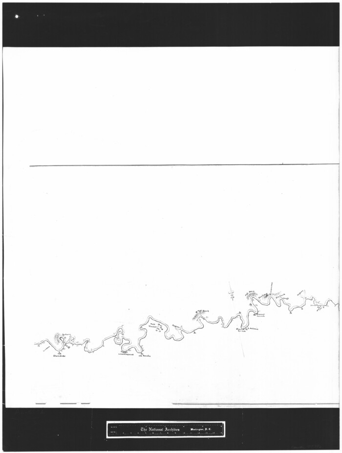
[Sketch showing the Rio Grande with towns and features annotated]
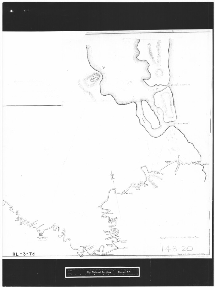
Print $20.00
- Digital $50.00
[Sketch showing the Rio Grande with towns and features annotated]
1854
Size: 24.4 x 18.3 inches
72895
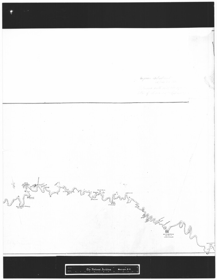
[Sketch showing the Rio Grande with towns and features annotated]
Print $20.00
- Digital $50.00
[Sketch showing the Rio Grande with towns and features annotated]
1854
Size: 24.1 x 18.2 inches
72896
[Sketch showing the Rio Grande with towns and features annotated]
Print $20.00
- Digital $50.00
[Sketch showing the Rio Grande with towns and features annotated]
1854
Size: 23.7 x 18.4 inches
72897
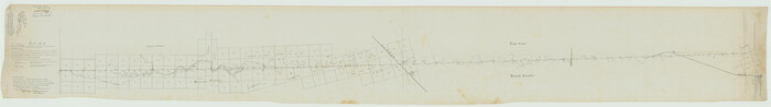
[Plat No. 1, Connecting line from SW corner of Jones Co. to SE corner of Borden Co.]
Print $40.00
- Digital $50.00
[Plat No. 1, Connecting line from SW corner of Jones Co. to SE corner of Borden Co.]
1908
Size: 18.1 x 128.8 inches
1698
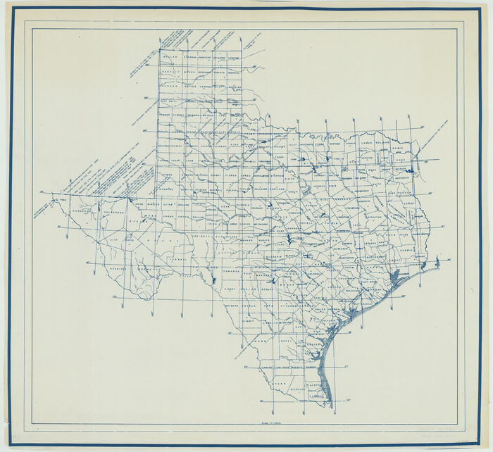
[Map of Texas showing Counties, County Seats, Rivers and Location of State Boundary Line Markers]
Print $20.00
- Digital $50.00
[Map of Texas showing Counties, County Seats, Rivers and Location of State Boundary Line Markers]
1950
Size: 30.2 x 32.9 inches
60304
Zavala Empresario Colony. March 12, 1829

Print $20.00
Zavala Empresario Colony. March 12, 1829
2020
Size: 24.7 x 21.7 inches
96012
Yoakum County Sketch File 3

Print $54.00
- Digital $50.00
Yoakum County Sketch File 3
1892
Size: 14.2 x 8.8 inches
40705
Woodbury Empresario Colony. November 14, 1826

Print $20.00
Woodbury Empresario Colony. November 14, 1826
2020
Size: 14.7 x 21.8 inches
96011
Wilson Empresario Colony. May 27, 1826

Print $20.00
Wilson Empresario Colony. May 27, 1826
2020
Size: 19.4 x 21.6 inches
96010
Wichita County Rolled Sketch 18

Print $20.00
- Digital $50.00
Wichita County Rolled Sketch 18
1924
Size: 30.0 x 40.5 inches
8253
Wichita County Rolled Sketch 18

Print $20.00
- Digital $50.00
Wichita County Rolled Sketch 18
1923
Size: 25.7 x 38.0 inches
8254
Wavell Empresario Colony. Proposed, March 9, 1826

Print $20.00
Wavell Empresario Colony. Proposed, March 9, 1826
2020
Size: 16.0 x 21.7 inches
96009
Vehlein and Company Empresario Colony. November 17, 1828

Print $20.00
Vehlein and Company Empresario Colony. November 17, 1828
2020
Size: 20.8 x 21.7 inches
96008
Vehlein and Company Empresario Colony. December 21, 1826

Print $20.00
Vehlein and Company Empresario Colony. December 21, 1826
2020
Size: 20.8 x 21.7 inches
96007
USGS Topographic: Texas-Oklahoma Denison Quadrangle

Print $20.00
- Digital $50.00
USGS Topographic: Texas-Oklahoma Denison Quadrangle
1901
Size: 21.3 x 17.4 inches
75108
Treaty to Resolve Pending Boundary Differences and Maintain the Rio Grande and Colorado River as the International Boundary Between the United States of American and Mexico

Print $4.00
- Digital $50.00
Treaty to Resolve Pending Boundary Differences and Maintain the Rio Grande and Colorado River as the International Boundary Between the United States of American and Mexico
1970
Size: 12.3 x 19.0 inches
83098
Treaty to Resolve Pending Boundary Differences and Maintain the Rio Grande and Colorado River as the International Boundary Between the United States of American and Mexico

Print $4.00
- Digital $50.00
Treaty to Resolve Pending Boundary Differences and Maintain the Rio Grande and Colorado River as the International Boundary Between the United States of American and Mexico
1970
Size: 12.1 x 19.0 inches
83099
Treaty to Resolve Pending Boundary Differences and Maintain the Rio Grande and Colorado River as the International Boundary Between the United States of American and Mexico

Print $4.00
- Digital $50.00
Treaty to Resolve Pending Boundary Differences and Maintain the Rio Grande and Colorado River as the International Boundary Between the United States of American and Mexico
1970
Size: 12.2 x 19.0 inches
83100
Treaty to Resolve Pending Boundary Differences and Maintain the Rio Grande and Colorado River as the International Boundary Between the United States of American and Mexico

Print $4.00
- Digital $50.00
Treaty to Resolve Pending Boundary Differences and Maintain the Rio Grande and Colorado River as the International Boundary Between the United States of American and Mexico
1970
Size: 10.9 x 18.1 inches
83101
Treaty to Resolve Pending Boundary Differences and Maintain the Rio Grande and Colorado River as the International Boundary Between the United States of American and Mexico

Print $20.00
- Digital $50.00
Treaty to Resolve Pending Boundary Differences and Maintain the Rio Grande and Colorado River as the International Boundary Between the United States of American and Mexico
1970
Size: 11.1 x 35.8 inches
83102
Treaty to Resolve Pending Boundary Differences and Maintain the Rio Grande and Colorado River as the International Boundary Between the United States of American and Mexico

Print $20.00
- Digital $50.00
Treaty to Resolve Pending Boundary Differences and Maintain the Rio Grande and Colorado River as the International Boundary Between the United States of American and Mexico
1970
Size: 11.0 x 35.3 inches
83103
Treaty to Resolve Pending Boundary Differences and Maintain the Rio Grande and Colorado River as the International Boundary Between the United States of American and Mexico

Print $20.00
- Digital $50.00
Treaty to Resolve Pending Boundary Differences and Maintain the Rio Grande and Colorado River as the International Boundary Between the United States of American and Mexico
1970
Size: 10.9 x 35.6 inches
83104
Treaty to Resolve Pending Boundary Differences and Maintain the Rio Grande and Colorado River as the International Boundary Between the United States of American and Mexico

Print $20.00
- Digital $50.00
Treaty to Resolve Pending Boundary Differences and Maintain the Rio Grande and Colorado River as the International Boundary Between the United States of American and Mexico
1970
Size: 11.0 x 35.2 inches
83105
Treaty to Resolve Pending Boundary Differences and Maintain the Rio Grande and Colorado River as the International Boundary Between the United States of American and Mexico

Print $20.00
- Digital $50.00
Treaty to Resolve Pending Boundary Differences and Maintain the Rio Grande and Colorado River as the International Boundary Between the United States of American and Mexico
1970
Size: 10.8 x 29.8 inches
83106
de Leon Empresario Colony. April 30, 1829
Print $20.00
de Leon Empresario Colony. April 30, 1829
2020
-
Size
18.5 x 21.7 inches
-
Map/Doc
95990
-
Creation Date
2020
de Leon Empresario Colony. April 15, 1824
Print $20.00
de Leon Empresario Colony. April 15, 1824
2020
-
Size
18.5 x 21.7 inches
-
Map/Doc
95988
-
Creation Date
2020
de Leon Empresario Colony. Absorbed by DeWitt Colony. April 15, 1825
Print $20.00
de Leon Empresario Colony. Absorbed by DeWitt Colony. April 15, 1825
2020
-
Size
18.5 x 21.7 inches
-
Map/Doc
95989
-
Creation Date
2020
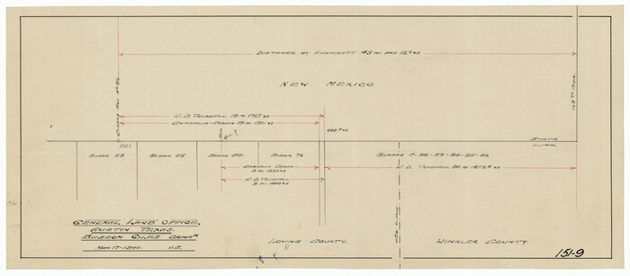
[Texas, New Mexico Clark's Monument #26]
Print $3.00
- Digital $50.00
[Texas, New Mexico Clark's Monument #26]
1941
-
Size
16.1 x 7.4 inches
-
Map/Doc
91309
-
Creation Date
1941
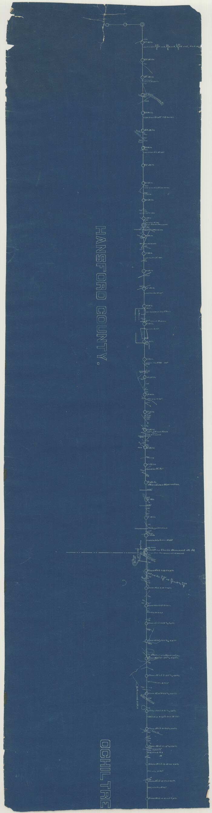
[Texas Panhandle North Boundary Line]
Print $20.00
- Digital $50.00
[Texas Panhandle North Boundary Line]
1898
-
Size
43.6 x 11.4 inches
-
Map/Doc
1714
-
Creation Date
1898
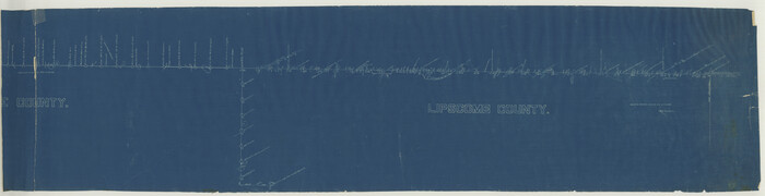
[Texas Panhandle North Boundary Line]
Print $20.00
- Digital $50.00
[Texas Panhandle North Boundary Line]
1898
-
Size
11.9 x 46.1 inches
-
Map/Doc
1737
-
Creation Date
1898
[Sketch showing the Rio Grande with towns and features annotated]
Print $20.00
- Digital $50.00
[Sketch showing the Rio Grande with towns and features annotated]
1854
-
Size
24.4 x 18.3 inches
-
Map/Doc
72895
-
Creation Date
1854
[Sketch showing the Rio Grande with towns and features annotated]
Print $20.00
- Digital $50.00
[Sketch showing the Rio Grande with towns and features annotated]
1854
-
Size
24.1 x 18.2 inches
-
Map/Doc
72896
-
Creation Date
1854
[Sketch showing the Rio Grande with towns and features annotated]
Print $20.00
- Digital $50.00
[Sketch showing the Rio Grande with towns and features annotated]
1854
-
Size
23.7 x 18.4 inches
-
Map/Doc
72897
-
Creation Date
1854
[Plat No. 1, Connecting line from SW corner of Jones Co. to SE corner of Borden Co.]
Print $40.00
- Digital $50.00
[Plat No. 1, Connecting line from SW corner of Jones Co. to SE corner of Borden Co.]
1908
-
Size
18.1 x 128.8 inches
-
Map/Doc
1698
-
Creation Date
1908
[Map of Texas showing Counties, County Seats, Rivers and Location of State Boundary Line Markers]
Print $20.00
- Digital $50.00
[Map of Texas showing Counties, County Seats, Rivers and Location of State Boundary Line Markers]
1950
-
Size
30.2 x 32.9 inches
-
Map/Doc
60304
-
Creation Date
1950
Zavala Empresario Colony. March 12, 1829
Print $20.00
Zavala Empresario Colony. March 12, 1829
2020
-
Size
24.7 x 21.7 inches
-
Map/Doc
96012
-
Creation Date
2020
Yoakum County Sketch File 3
Print $54.00
- Digital $50.00
Yoakum County Sketch File 3
1892
-
Size
14.2 x 8.8 inches
-
Map/Doc
40705
-
Creation Date
1892
Woodbury Empresario Colony. November 14, 1826
Print $20.00
Woodbury Empresario Colony. November 14, 1826
2020
-
Size
14.7 x 21.8 inches
-
Map/Doc
96011
-
Creation Date
2020
Wilson Empresario Colony. May 27, 1826
Print $20.00
Wilson Empresario Colony. May 27, 1826
2020
-
Size
19.4 x 21.6 inches
-
Map/Doc
96010
-
Creation Date
2020
Wichita County Rolled Sketch 18
Print $20.00
- Digital $50.00
Wichita County Rolled Sketch 18
1924
-
Size
30.0 x 40.5 inches
-
Map/Doc
8253
-
Creation Date
1924
Wichita County Rolled Sketch 18
Print $20.00
- Digital $50.00
Wichita County Rolled Sketch 18
1923
-
Size
25.7 x 38.0 inches
-
Map/Doc
8254
-
Creation Date
1923
Wavell Empresario Colony. Proposed, March 9, 1826
Print $20.00
Wavell Empresario Colony. Proposed, March 9, 1826
2020
-
Size
16.0 x 21.7 inches
-
Map/Doc
96009
-
Creation Date
2020
Vehlein and Company Empresario Colony. November 17, 1828
Print $20.00
Vehlein and Company Empresario Colony. November 17, 1828
2020
-
Size
20.8 x 21.7 inches
-
Map/Doc
96008
-
Creation Date
2020
Vehlein and Company Empresario Colony. December 21, 1826
Print $20.00
Vehlein and Company Empresario Colony. December 21, 1826
2020
-
Size
20.8 x 21.7 inches
-
Map/Doc
96007
-
Creation Date
2020
USGS Topographic: Texas-Oklahoma Denison Quadrangle
Print $20.00
- Digital $50.00
USGS Topographic: Texas-Oklahoma Denison Quadrangle
1901
-
Size
21.3 x 17.4 inches
-
Map/Doc
75108
-
Creation Date
1901
Treaty to Resolve Pending Boundary Differences and Maintain the Rio Grande and Colorado River as the International Boundary Between the United States of American and Mexico
Print $4.00
- Digital $50.00
Treaty to Resolve Pending Boundary Differences and Maintain the Rio Grande and Colorado River as the International Boundary Between the United States of American and Mexico
1970
-
Size
12.3 x 19.0 inches
-
Map/Doc
83098
-
Creation Date
1970
Treaty to Resolve Pending Boundary Differences and Maintain the Rio Grande and Colorado River as the International Boundary Between the United States of American and Mexico
Print $4.00
- Digital $50.00
Treaty to Resolve Pending Boundary Differences and Maintain the Rio Grande and Colorado River as the International Boundary Between the United States of American and Mexico
1970
-
Size
12.1 x 19.0 inches
-
Map/Doc
83099
-
Creation Date
1970
Treaty to Resolve Pending Boundary Differences and Maintain the Rio Grande and Colorado River as the International Boundary Between the United States of American and Mexico
Print $4.00
- Digital $50.00
Treaty to Resolve Pending Boundary Differences and Maintain the Rio Grande and Colorado River as the International Boundary Between the United States of American and Mexico
1970
-
Size
12.2 x 19.0 inches
-
Map/Doc
83100
-
Creation Date
1970
Treaty to Resolve Pending Boundary Differences and Maintain the Rio Grande and Colorado River as the International Boundary Between the United States of American and Mexico
Print $4.00
- Digital $50.00
Treaty to Resolve Pending Boundary Differences and Maintain the Rio Grande and Colorado River as the International Boundary Between the United States of American and Mexico
1970
-
Size
10.9 x 18.1 inches
-
Map/Doc
83101
-
Creation Date
1970
Treaty to Resolve Pending Boundary Differences and Maintain the Rio Grande and Colorado River as the International Boundary Between the United States of American and Mexico
Print $20.00
- Digital $50.00
Treaty to Resolve Pending Boundary Differences and Maintain the Rio Grande and Colorado River as the International Boundary Between the United States of American and Mexico
1970
-
Size
11.1 x 35.8 inches
-
Map/Doc
83102
-
Creation Date
1970
Treaty to Resolve Pending Boundary Differences and Maintain the Rio Grande and Colorado River as the International Boundary Between the United States of American and Mexico
Print $20.00
- Digital $50.00
Treaty to Resolve Pending Boundary Differences and Maintain the Rio Grande and Colorado River as the International Boundary Between the United States of American and Mexico
1970
-
Size
11.0 x 35.3 inches
-
Map/Doc
83103
-
Creation Date
1970
Treaty to Resolve Pending Boundary Differences and Maintain the Rio Grande and Colorado River as the International Boundary Between the United States of American and Mexico
Print $20.00
- Digital $50.00
Treaty to Resolve Pending Boundary Differences and Maintain the Rio Grande and Colorado River as the International Boundary Between the United States of American and Mexico
1970
-
Size
10.9 x 35.6 inches
-
Map/Doc
83104
-
Creation Date
1970
Treaty to Resolve Pending Boundary Differences and Maintain the Rio Grande and Colorado River as the International Boundary Between the United States of American and Mexico
Print $20.00
- Digital $50.00
Treaty to Resolve Pending Boundary Differences and Maintain the Rio Grande and Colorado River as the International Boundary Between the United States of American and Mexico
1970
-
Size
11.0 x 35.2 inches
-
Map/Doc
83105
-
Creation Date
1970
Treaty to Resolve Pending Boundary Differences and Maintain the Rio Grande and Colorado River as the International Boundary Between the United States of American and Mexico
Print $20.00
- Digital $50.00
Treaty to Resolve Pending Boundary Differences and Maintain the Rio Grande and Colorado River as the International Boundary Between the United States of American and Mexico
1970
-
Size
10.8 x 29.8 inches
-
Map/Doc
83106
-
Creation Date
1970