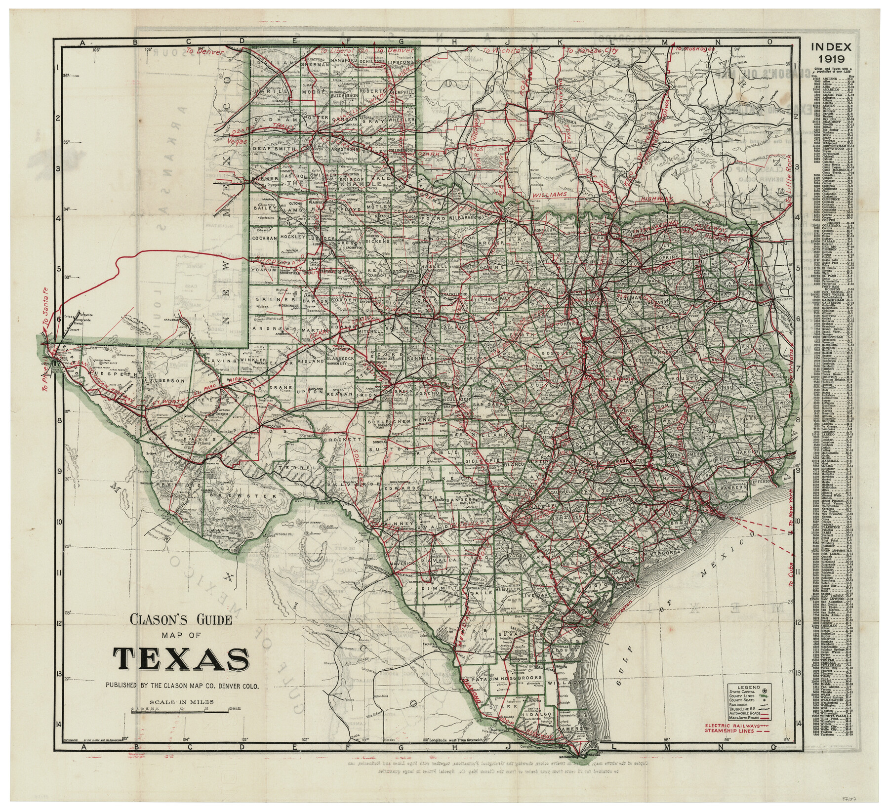
Clason's Guide Map of Texas
-
Map/Doc
97157
-
Collection
General Map Collection
-
Object Dates
1919 (Creation Date)
-
People and Organizations
The Clason Map Co. (Publisher)
-
Subjects
State of Texas
-
Height x Width
22.4 x 24.5 inches
56.9 x 62.2 cm
-
Comments
To view map on verso see 97158.
To view booklet in which this map was attached, click the "Download PDF" link above.
Related maps
Clason's Oil Map of Texas and Oklahoma showing the location and approximate area of the oil and gas fields

Print $20.00
- Digital $50.00
Clason's Oil Map of Texas and Oklahoma showing the location and approximate area of the oil and gas fields
1919
Size 22.4 x 24.5 inches
Map/Doc 97158
Part of: General Map Collection
Atascosa County Sketch File 27b

Print $10.00
- Digital $50.00
Atascosa County Sketch File 27b
1875
Size 12.6 x 8.2 inches
Map/Doc 13801
Calhoun County Rolled Sketch 12

Print $40.00
- Digital $50.00
Calhoun County Rolled Sketch 12
1940
Size 30.2 x 54.8 inches
Map/Doc 43619
Jack County Boundary File 3a

Print $50.00
- Digital $50.00
Jack County Boundary File 3a
Size 8.7 x 7.4 inches
Map/Doc 55413
Robertson County Working Sketch 12

Print $4.00
- Digital $50.00
Robertson County Working Sketch 12
Size 20.6 x 22.4 inches
Map/Doc 63585
Nueces County Sketch File 83

Print $63.00
- Digital $50.00
Nueces County Sketch File 83
1997
Size 11.1 x 8.5 inches
Map/Doc 43013
Burnet County Boundary File 12a

Print $8.00
- Digital $50.00
Burnet County Boundary File 12a
Size 12.9 x 8.7 inches
Map/Doc 50956
Prison Property, Walker Co.

Print $20.00
- Digital $50.00
Prison Property, Walker Co.
Size 19.3 x 20.2 inches
Map/Doc 94278
Johnson County Sketch File 3

Print $4.00
- Digital $50.00
Johnson County Sketch File 3
Size 10.1 x 8.0 inches
Map/Doc 28433
MKT (Missouri Kansas Texas) Katy Railroad Time Tables

Print $54.00
- Digital $50.00
MKT (Missouri Kansas Texas) Katy Railroad Time Tables
1946
Size 9.3 x 16.4 inches
Map/Doc 93981
Bandera County Sketch File 33

Print $40.00
- Digital $50.00
Bandera County Sketch File 33
1975
Size 14.4 x 17.5 inches
Map/Doc 14028
Map of San Augustine County

Print $20.00
- Digital $50.00
Map of San Augustine County
1839
Size 22.3 x 18.2 inches
Map/Doc 4011
Ward County Rolled Sketch 27

Print $20.00
- Digital $50.00
Ward County Rolled Sketch 27
1982
Size 22.7 x 16.5 inches
Map/Doc 8166
You may also like
Franklin County Sketch File 17

Print $16.00
- Digital $50.00
Franklin County Sketch File 17
1951
Size 11.3 x 8.8 inches
Map/Doc 23026
Map of Lands in Pecos County, Texas, Block 1, I. and G. N. RR. Company

Print $20.00
- Digital $50.00
Map of Lands in Pecos County, Texas, Block 1, I. and G. N. RR. Company
1934
Size 21.9 x 16.8 inches
Map/Doc 91640
Saline Ranch in Mason, Kimble and Menard Counties

Print $20.00
- Digital $50.00
Saline Ranch in Mason, Kimble and Menard Counties
1916
Size 28.2 x 27.1 inches
Map/Doc 75807
[East line of North Part of Childress County along border with Oklahoma]
![92084, [East line of North Part of Childress County along border with Oklahoma], Twichell Survey Records](https://historictexasmaps.com/wmedia_w700/maps/92084-1.tif.jpg)
Print $20.00
- Digital $50.00
[East line of North Part of Childress County along border with Oklahoma]
Size 20.4 x 6.1 inches
Map/Doc 92084
Bee County Working Sketch 29b

Print $20.00
- Digital $50.00
Bee County Working Sketch 29b
1988
Size 34.4 x 36.3 inches
Map/Doc 67280
Stephens County Sketch File 28

Print $14.00
- Digital $50.00
Stephens County Sketch File 28
1996
Size 14.2 x 8.6 inches
Map/Doc 37104
Schleicher County Sketch File 25

Print $20.00
- Digital $50.00
Schleicher County Sketch File 25
1937
Size 24.1 x 17.5 inches
Map/Doc 12304
Amistad International Reservoir on Rio Grande 63

Print $20.00
- Digital $50.00
Amistad International Reservoir on Rio Grande 63
1949
Size 28.2 x 39.5 inches
Map/Doc 73348
South Part of Webb County

Print $40.00
- Digital $50.00
South Part of Webb County
1984
Size 43.5 x 63.9 inches
Map/Doc 73320

Map of Johnson County & Hood County

Print $20.00
- Digital $50.00
Map of Johnson County & Hood County
1863
Size 19.3 x 28.3 inches
Map/Doc 3735
Map of Callahan Co[unty]
![88916, Map of Callahan Co[unty], Library of Congress](https://historictexasmaps.com/wmedia_w700/maps/88916.tif.jpg)
Print $20.00
Map of Callahan Co[unty]
1879
Size 24.7 x 18.5 inches
Map/Doc 88916