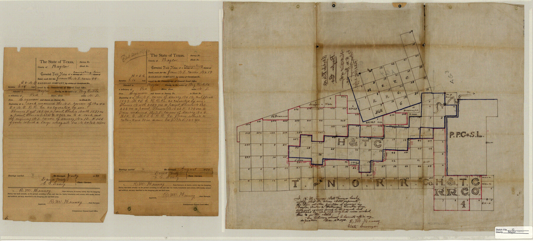
Baylor County Sketch File 10
[Sketch and connecting line field notes of area in northeast part of county]
-
Map/Doc
10321
-
Collection
General Map Collection
-
Object Dates
1890/12/16 (Creation Date)
1890/11/21 (File Date)
1890 (Survey Date)
1890 (Survey Date)
-
People and Organizations
R.M. Kenney (Surveyor/Engineer)
David Beaty (Chainman/Field Personnel)
G.C. Leary (Chainman/Field Personnel)
-
Counties
Baylor Wilbarger Archer
-
Subjects
Surveying Sketch File
-
Height x Width
19.3 x 42.7 inches
49.0 x 108.5 cm
-
Medium
multi-page, multi-format
Part of: General Map Collection
Stonewall County Working Sketch 9

Print $20.00
- Digital $50.00
Stonewall County Working Sketch 9
1950
Size 27.9 x 34.1 inches
Map/Doc 62316
Medina County Working Sketch 5

Print $20.00
- Digital $50.00
Medina County Working Sketch 5
1949
Size 38.5 x 37.3 inches
Map/Doc 70920
Map of Marion County

Print $20.00
- Digital $50.00
Map of Marion County
1920
Size 29.2 x 42.2 inches
Map/Doc 78405
Brazoria County Working Sketch 7

Print $20.00
- Digital $50.00
Brazoria County Working Sketch 7
1930
Size 40.9 x 21.1 inches
Map/Doc 67492

Fannin County Sketch File 25

Print $4.00
- Digital $50.00
Fannin County Sketch File 25
1847
Size 8.5 x 10.9 inches
Map/Doc 22493
[Surveys in Austin's Colony along the Brazos River]
![164, [Surveys in Austin's Colony along the Brazos River], General Map Collection](https://historictexasmaps.com/wmedia_w700/maps/164.tif.jpg)
Print $20.00
- Digital $50.00
[Surveys in Austin's Colony along the Brazos River]
1833
Size 25.0 x 23.9 inches
Map/Doc 164
Galveston County Working Sketch 14

Print $20.00
- Digital $50.00
Galveston County Working Sketch 14
1978
Size 33.6 x 40.4 inches
Map/Doc 69351
Flight Mission No. BRA-7M, Frame 15, Jefferson County

Print $20.00
- Digital $50.00
Flight Mission No. BRA-7M, Frame 15, Jefferson County
1953
Size 18.6 x 22.3 inches
Map/Doc 85466
Pecos County Rolled Sketch 28

Print $20.00
- Digital $50.00
Pecos County Rolled Sketch 28
1890
Size 18.9 x 38.5 inches
Map/Doc 7213
McCulloch County Sketch File 3

Print $12.00
- Digital $50.00
McCulloch County Sketch File 3
1893
Size 11.1 x 8.5 inches
Map/Doc 31169
Pecos County Sketch File 95

Print $6.00
- Digital $50.00
Pecos County Sketch File 95
1956
Size 11.2 x 8.8 inches
Map/Doc 33995
You may also like
Flight Mission No. BRA-16M, Frame 74, Jefferson County

Print $20.00
- Digital $50.00
Flight Mission No. BRA-16M, Frame 74, Jefferson County
1953
Size 18.6 x 22.5 inches
Map/Doc 85691
Flight Mission No. CGI-3N, Frame 177, Cameron County

Print $20.00
- Digital $50.00
Flight Mission No. CGI-3N, Frame 177, Cameron County
1954
Size 18.5 x 22.3 inches
Map/Doc 84641
Hudspeth County Working Sketch 23

Print $40.00
- Digital $50.00
Hudspeth County Working Sketch 23
1967
Size 52.7 x 34.3 inches
Map/Doc 69650
Liberty County Working Sketch 44

Print $20.00
- Digital $50.00
Liberty County Working Sketch 44
1953
Size 21.3 x 30.2 inches
Map/Doc 70503
Cochran County Rolled Sketch 6

Print $20.00
- Digital $50.00
Cochran County Rolled Sketch 6
2025
Size 20.5 x 28.2 inches
Map/Doc 97417
Current Miscellaneous File 13

Print $20.00
- Digital $50.00
Current Miscellaneous File 13
Size 16.2 x 21.6 inches
Map/Doc 73820
Ochiltree County Working Sketch 9

Print $20.00
- Digital $50.00
Ochiltree County Working Sketch 9
1990
Size 37.1 x 37.4 inches
Map/Doc 71322
Flight Mission No. DIX-5P, Frame 103, Aransas County

Print $20.00
- Digital $50.00
Flight Mission No. DIX-5P, Frame 103, Aransas County
1956
Size 17.5 x 18.2 inches
Map/Doc 83781
[North line of County]
![93146, [North line of County], Twichell Survey Records](https://historictexasmaps.com/wmedia_w700/maps/93146-1.tif.jpg)
Print $40.00
- Digital $50.00
[North line of County]
Size 76.2 x 8.6 inches
Map/Doc 93146
Working Sketch in Matagorda County

Print $20.00
- Digital $50.00
Working Sketch in Matagorda County
1890
Size 36.6 x 22.7 inches
Map/Doc 4479

Map of Hall County

Print $20.00
- Digital $50.00
Map of Hall County
1900
Size 41.2 x 41.3 inches
Map/Doc 16842