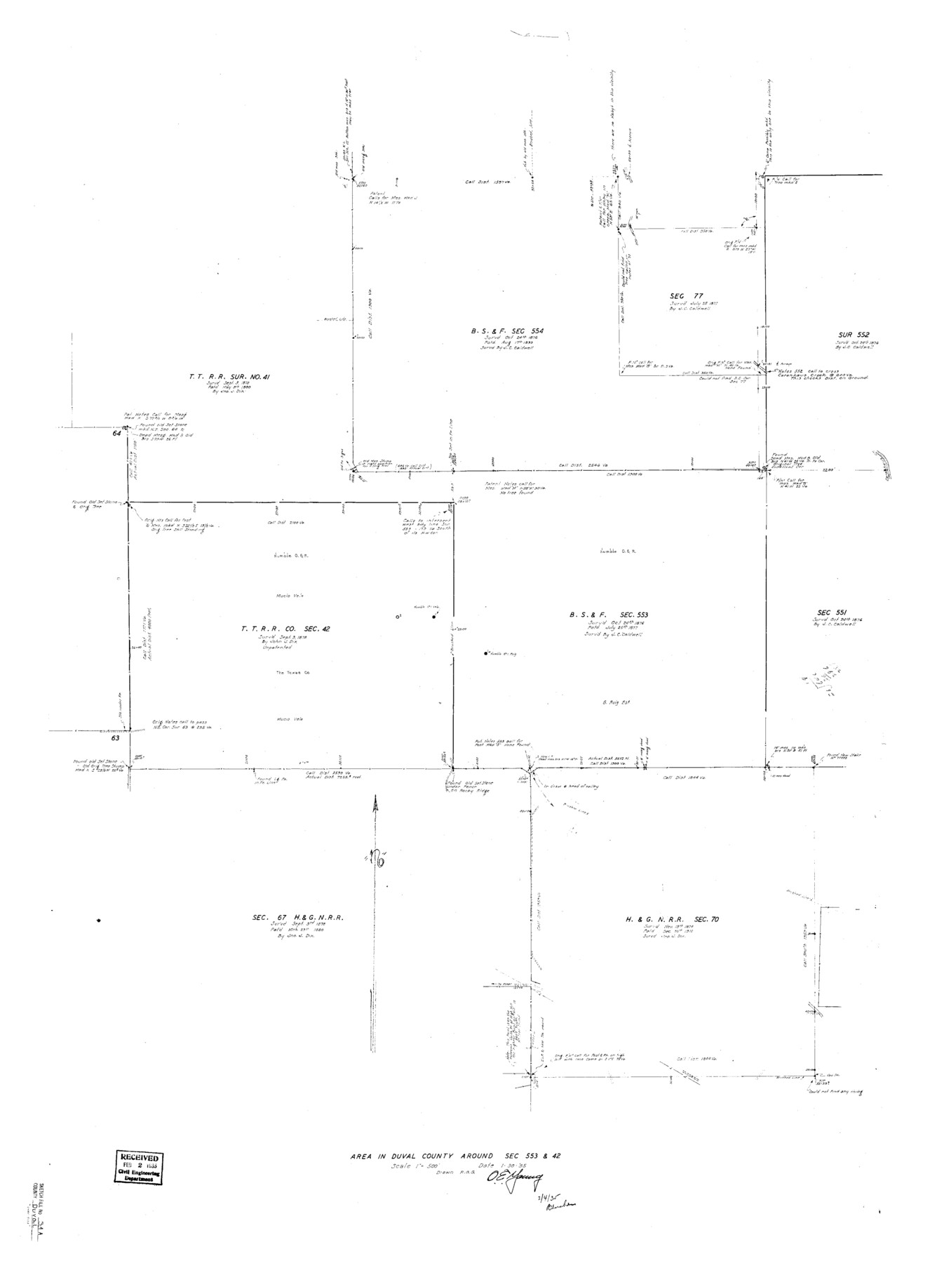
Duval County Sketch File 34a
Area in Duval County Around Sec. 553 & 42
-
Map/Doc
10369
-
Collection
General Map Collection
-
Object Dates
1935/2/4 (File Date)
1876 (Survey Date)
1878 (Survey Date)
1874 (Survey Date)
1935/1/30 (Creation Date)
-
People and Organizations
J.C. Caldwell (Surveyor/Engineer)
John J. Dix (Surveyor/Engineer)
R.G.G. (Draftsman)
O.E. Young (Surveyor/Engineer)
-
Counties
Duval
-
Subjects
Surveying Sketch File
-
Height x Width
45.7 x 34.2 inches
116.1 x 86.9 cm
-
Medium
paper, photocopy
-
Scale
1" = 500 feet
-
Features
Carankaus [sic] Creek
Part of: General Map Collection
Current Miscellaneous File 82

Print $4.00
- Digital $50.00
Current Miscellaneous File 82
Size 12.0 x 8.8 inches
Map/Doc 74224
Fractional Township No. 8 South Range No. 18 East of the Indian Meridian, Indian Territory

Print $20.00
- Digital $50.00
Fractional Township No. 8 South Range No. 18 East of the Indian Meridian, Indian Territory
1897
Size 19.2 x 24.3 inches
Map/Doc 75233
Terrell County Sketch File 22W

Print $20.00
- Digital $50.00
Terrell County Sketch File 22W
Size 19.6 x 21.7 inches
Map/Doc 12423
Plano de la Nueva España en que se señalan los Viages que hizo el Capitan Hernan Cortes assi antes como despues de conquistado el Imperio Mexicano

Print $20.00
- Digital $50.00
Plano de la Nueva España en que se señalan los Viages que hizo el Capitan Hernan Cortes assi antes como despues de conquistado el Imperio Mexicano
1769
Size 14.4 x 17.5 inches
Map/Doc 97352
McMullen County Rolled Sketch 20

Print $20.00
- Digital $50.00
McMullen County Rolled Sketch 20
Size 27.7 x 21.7 inches
Map/Doc 6736
[Sketch for Mineral Application 36486 and 38244 - Liberty County]
![65621, [Sketch for Mineral Application 36486 and 38244 - Liberty County], General Map Collection](https://historictexasmaps.com/wmedia_w700/maps/65621.tif.jpg)
Print $20.00
- Digital $50.00
[Sketch for Mineral Application 36486 and 38244 - Liberty County]
1976
Size 24.0 x 43.9 inches
Map/Doc 65621
Flight Mission No. DQN-2K, Frame 2, Calhoun County

Print $20.00
- Digital $50.00
Flight Mission No. DQN-2K, Frame 2, Calhoun County
1953
Size 18.6 x 22.3 inches
Map/Doc 84219
McMullen County Working Sketch 60

Print $20.00
- Digital $50.00
McMullen County Working Sketch 60
1987
Size 23.0 x 32.6 inches
Map/Doc 70761
Nolan County Sketch File 13

Print $20.00
- Digital $50.00
Nolan County Sketch File 13
1886
Size 17.8 x 29.9 inches
Map/Doc 42207
Gillespie County Rolled Sketch 7

Print $20.00
- Digital $50.00
Gillespie County Rolled Sketch 7
2008
Size 18.9 x 18.8 inches
Map/Doc 88818
Leon County Rolled Sketch 2

Print $20.00
- Digital $50.00
Leon County Rolled Sketch 2
Size 30.7 x 34.6 inches
Map/Doc 6606
Lipscomb County Sketch File 4

Print $56.00
- Digital $50.00
Lipscomb County Sketch File 4
1910
Size 11.2 x 8.7 inches
Map/Doc 30233
You may also like
Maverick County Working Sketch 6

Print $40.00
- Digital $50.00
Maverick County Working Sketch 6
1944
Size 55.9 x 42.4 inches
Map/Doc 70898
[Strip between Block 8 and Block K4]
![90525, [Strip between Block 8 and Block K4], Twichell Survey Records](https://historictexasmaps.com/wmedia_w700/maps/90525-1.tif.jpg)
Print $2.00
- Digital $50.00
[Strip between Block 8 and Block K4]
Size 5.7 x 7.5 inches
Map/Doc 90525
Sketch showing Mineral Leases in Nueces Bay

Print $20.00
- Digital $50.00
Sketch showing Mineral Leases in Nueces Bay
1942
Size 14.3 x 24.3 inches
Map/Doc 3019
Bailey County Sketch File 6

Print $40.00
- Digital $50.00
Bailey County Sketch File 6
Size 26.5 x 31.9 inches
Map/Doc 10884
[Northeast 1/4 of County]
![91629, [Northeast 1/4 of County], Twichell Survey Records](https://historictexasmaps.com/wmedia_w700/maps/91629-1.tif.jpg)
Print $2.00
- Digital $50.00
[Northeast 1/4 of County]
Size 12.3 x 9.0 inches
Map/Doc 91629
Matagorda County NRC Article 33.136 Sketch 22

Print $24.00
Matagorda County NRC Article 33.136 Sketch 22
2025
Map/Doc 97486
Flight Mission No. BQR-9K, Frame 48, Brazoria County

Print $20.00
- Digital $50.00
Flight Mission No. BQR-9K, Frame 48, Brazoria County
1952
Size 18.7 x 22.2 inches
Map/Doc 84052
Mitchell County Boundary File 1a

Print $32.00
- Digital $50.00
Mitchell County Boundary File 1a
Size 13.4 x 8.6 inches
Map/Doc 57344
Hudspeth County Sketch File 54

Print $4.00
- Digital $50.00
Hudspeth County Sketch File 54
1993
Size 8.9 x 14.2 inches
Map/Doc 27079
[Surveys in Polk County]
![329, [Surveys in Polk County], General Map Collection](https://historictexasmaps.com/wmedia_w700/maps/329.tif.jpg)
Print $2.00
- Digital $50.00
[Surveys in Polk County]
1847
Size 6.6 x 8.0 inches
Map/Doc 329
[Aransas National Wildlife Refuge]
![3119, [Aransas National Wildlife Refuge], General Map Collection](https://historictexasmaps.com/wmedia_w700/maps/3119-1.tif.jpg)
Print $40.00
- Digital $50.00
[Aransas National Wildlife Refuge]
1952
Size 55.9 x 43.4 inches
Map/Doc 3119
Duval County Working Sketch 19

Print $20.00
- Digital $50.00
Duval County Working Sketch 19
1940
Size 21.7 x 18.5 inches
Map/Doc 68732