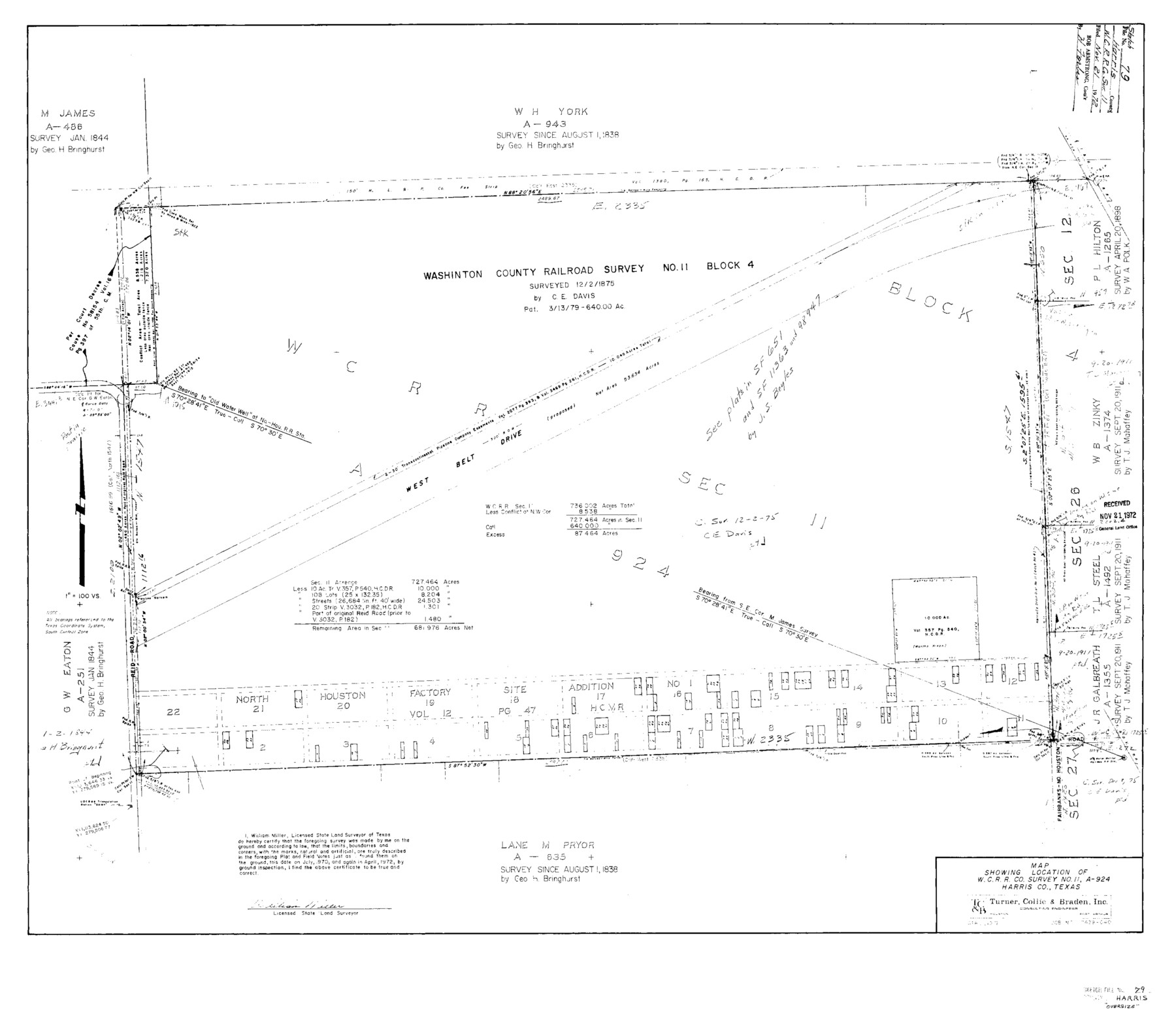
Harris County Sketch File 79
Washington County Railroad Survey No. 11 Block 4
-
Map/Doc
10481
-
Collection
General Map Collection
-
Object Dates
1972 (Creation Date)
1972/11/21 (File Date)
1844 (Survey Date)
1838 (Survey Date)
1898 (Survey Date)
1970 (Survey Date)
1972 (Survey Date)
-
People and Organizations
George H. Bringhurst (Surveyor/Engineer)
William Miller (Surveyor/Engineer)
-
Counties
Harris
-
Subjects
Surveying Sketch File
-
Height x Width
28.9 x 33.2 inches
73.4 x 84.3 cm
-
Medium
paper, print
-
Features
West Belt Drive
Reid Road
Part of: General Map Collection
Presidio County Working Sketch 139

Print $20.00
- Digital $50.00
Presidio County Working Sketch 139
1990
Size 34.7 x 38.2 inches
Map/Doc 71817
Current Miscellaneous File 83

Print $2.00
- Digital $50.00
Current Miscellaneous File 83
1936
Size 8.3 x 10.6 inches
Map/Doc 74226
Map of The Surveyed Part of Peters Colony Texas

Print $40.00
- Digital $50.00
Map of The Surveyed Part of Peters Colony Texas
1852
Size 54.6 x 34.6 inches
Map/Doc 4654
Presidio County Rolled Sketch 30

Print $40.00
- Digital $50.00
Presidio County Rolled Sketch 30
Size 40.8 x 84.9 inches
Map/Doc 9767
Navigation Maps of Gulf Intracoastal Waterway, Port Arthur to Brownsville, Texas

Print $4.00
- Digital $50.00
Navigation Maps of Gulf Intracoastal Waterway, Port Arthur to Brownsville, Texas
1951
Size 16.7 x 21.6 inches
Map/Doc 65426
Nautical Chart 152-SC - Galveston Bay, Texas

Print $20.00
- Digital $50.00
Nautical Chart 152-SC - Galveston Bay, Texas
1972
Size 14.9 x 32.8 inches
Map/Doc 69889

Jeff Davis County Working Sketch 12

Print $20.00
- Digital $50.00
Jeff Davis County Working Sketch 12
1948
Size 21.5 x 29.0 inches
Map/Doc 66507
Pecos County Rolled Sketch 97

Print $20.00
- Digital $50.00
Pecos County Rolled Sketch 97
Size 24.7 x 36.8 inches
Map/Doc 7248
Orange County Rolled Sketch 18

Print $20.00
- Digital $50.00
Orange County Rolled Sketch 18
Size 11.6 x 12.6 inches
Map/Doc 7182
J No. 9 - Reconnaissance of the Western Coast of the United States from San Francisco to San Diego

Print $20.00
- Digital $50.00
J No. 9 - Reconnaissance of the Western Coast of the United States from San Francisco to San Diego
1852
Size 24.5 x 24.4 inches
Map/Doc 97236
Real County Working Sketch 82

Print $20.00
- Digital $50.00
Real County Working Sketch 82
1985
Size 24.9 x 23.5 inches
Map/Doc 71974
You may also like
Official Map of the Highway System of Texas

Print $20.00
- Digital $50.00
Official Map of the Highway System of Texas
1936
Size 27.5 x 33.4 inches
Map/Doc 83599
Sketch from the map of Bailey Co.

Print $2.00
- Digital $50.00
Sketch from the map of Bailey Co.
Size 8.4 x 7.6 inches
Map/Doc 464
Freestone County

Print $40.00
- Digital $50.00
Freestone County
1988
Size 49.0 x 43.4 inches
Map/Doc 95502
Sulphur River, Dunbar Creek Sheet

Print $4.00
- Digital $50.00
Sulphur River, Dunbar Creek Sheet
1941
Size 17.2 x 20.9 inches
Map/Doc 65174
Hale County Sketch File 16

Print $4.00
- Digital $50.00
Hale County Sketch File 16
1888
Size 12.8 x 8.2 inches
Map/Doc 24747
[Sketch of Leagues 458, 459, 474, 475, 480 and 481]
![91547, [Sketch of Leagues 458, 459, 474, 475, 480 and 481], Twichell Survey Records](https://historictexasmaps.com/wmedia_w700/maps/91547-1.tif.jpg)
Print $2.00
- Digital $50.00
[Sketch of Leagues 458, 459, 474, 475, 480 and 481]
Size 5.2 x 8.3 inches
Map/Doc 91547
Hardin County Working Sketch 15

Print $20.00
- Digital $50.00
Hardin County Working Sketch 15
1939
Size 21.1 x 34.6 inches
Map/Doc 63413
Flight Mission No. DAG-26K, Frame 57, Matagorda County

Print $20.00
- Digital $50.00
Flight Mission No. DAG-26K, Frame 57, Matagorda County
1953
Size 18.5 x 22.6 inches
Map/Doc 86577
Terrell County Sketch File 13

Print $20.00
- Digital $50.00
Terrell County Sketch File 13
1911
Size 13.7 x 20.4 inches
Map/Doc 12420
Flight Mission No. DAG-21K, Frame 124, Matagorda County

Print $20.00
- Digital $50.00
Flight Mission No. DAG-21K, Frame 124, Matagorda County
1952
Size 18.5 x 22.4 inches
Map/Doc 86450
Colorado County Working Sketch 29

Print $20.00
- Digital $50.00
Colorado County Working Sketch 29
1980
Size 15.4 x 12.4 inches
Map/Doc 68129
Fort Bend County Sketch File 31

Print $10.00
- Digital $50.00
Fort Bend County Sketch File 31
1940
Size 13.3 x 8.7 inches
Map/Doc 22997