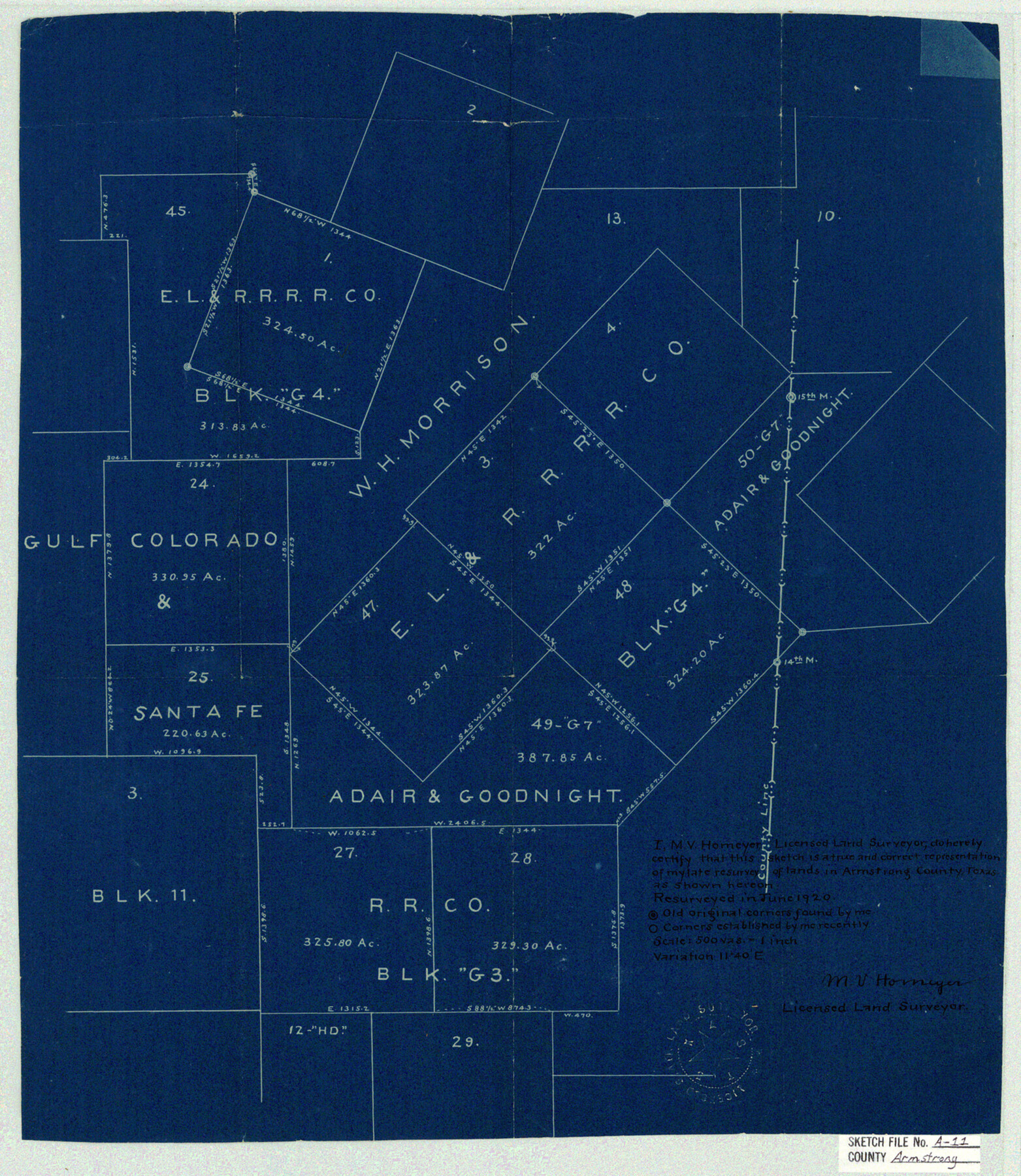
Armstrong County Sketch File A-11
[Sketch of parts of Blocks G3 and G4]
-
Map/Doc
10853
-
Collection
General Map Collection
-
Object Dates
1921/3/22 (File Date)
1920 (Survey Date)
-
People and Organizations
M.V. Homeyer (Surveyor/Engineer)
-
Counties
Armstrong
-
Subjects
Surveying Sketch File
-
Height x Width
17.0 x 14.8 inches
43.2 x 37.6 cm
-
Medium
blueprint/diazo
-
Scale
1" = 500 varas
Part of: General Map Collection
Ector County Working Sketch Graphic Index - sheet B

Print $20.00
- Digital $50.00
Ector County Working Sketch Graphic Index - sheet B
1943
Size 43.9 x 37.7 inches
Map/Doc 76531
Cass County Texas

Print $20.00
- Digital $50.00
Cass County Texas
1879
Size 17.7 x 21.3 inches
Map/Doc 4516
Menard County Sketch File 18

Print $62.00
- Digital $50.00
Menard County Sketch File 18
1893
Size 8.7 x 8.1 inches
Map/Doc 31516
Navarro County Sketch File 10

Print $4.00
- Digital $50.00
Navarro County Sketch File 10
1860
Size 12.6 x 8.2 inches
Map/Doc 32318
Childress County

Print $20.00
- Digital $50.00
Childress County
1883
Size 20.6 x 17.4 inches
Map/Doc 3393
Stephens County Working Sketch 12

Print $20.00
- Digital $50.00
Stephens County Working Sketch 12
1947
Size 20.9 x 22.2 inches
Map/Doc 63955
Flight Mission No. DCL-5C, Frame 48, Kenedy County

Print $20.00
- Digital $50.00
Flight Mission No. DCL-5C, Frame 48, Kenedy County
1943
Size 18.6 x 22.2 inches
Map/Doc 85844
Map of Panola County Texas

Print $20.00
- Digital $50.00
Map of Panola County Texas
1850
Size 25.6 x 35.9 inches
Map/Doc 78317
That part of the boundary between the Republic of Texas and the United States, North of Sabine River from the 36th to the 72nd Mile Mound on the Meridian Line (Sheet No. 2)

Print $20.00
- Digital $50.00
That part of the boundary between the Republic of Texas and the United States, North of Sabine River from the 36th to the 72nd Mile Mound on the Meridian Line (Sheet No. 2)
1842
Size 33.7 x 26.0 inches
Map/Doc 3132
[St. Louis & Southwestern]
![64280, [St. Louis & Southwestern], General Map Collection](https://historictexasmaps.com/wmedia_w700/maps/64280.tif.jpg)
Print $20.00
- Digital $50.00
[St. Louis & Southwestern]
Size 20.3 x 27.9 inches
Map/Doc 64280
Kerr County Boundary File 4

Print $4.00
- Digital $50.00
Kerr County Boundary File 4
Size 11.1 x 8.3 inches
Map/Doc 64799
Jefferson Co.

Print $20.00
- Digital $50.00
Jefferson Co.
1978
Size 47.0 x 41.1 inches
Map/Doc 77329
You may also like
Flight Mission No. CZW-1R, Frame 165, Hardeman County

Print $20.00
- Digital $50.00
Flight Mission No. CZW-1R, Frame 165, Hardeman County
1956
Size 18.7 x 22.4 inches
Map/Doc 85236
Sketch of a reconnaissance of Aransas and Corpus Christi Bays

Print $20.00
- Digital $50.00
Sketch of a reconnaissance of Aransas and Corpus Christi Bays
1855
Size 25.5 x 18.2 inches
Map/Doc 72968
Crockett County Rolled Sketch 87

Print $20.00
- Digital $50.00
Crockett County Rolled Sketch 87
1967
Size 34.9 x 39.2 inches
Map/Doc 8726
Castro County Sketch File 7

Print $10.00
- Digital $50.00
Castro County Sketch File 7
1905
Size 10.9 x 8.0 inches
Map/Doc 17495
Calcasieu Pass to Sabine Pass

Print $20.00
- Digital $50.00
Calcasieu Pass to Sabine Pass
1925
Size 44.1 x 36.0 inches
Map/Doc 69804
Flight Mission No. CGI-4N, Frame 146, Cameron County

Print $20.00
- Digital $50.00
Flight Mission No. CGI-4N, Frame 146, Cameron County
1955
Size 18.7 x 22.3 inches
Map/Doc 84665
Tarrant County Working Sketch 21

Print $20.00
- Digital $50.00
Tarrant County Working Sketch 21
1999
Size 17.4 x 22.8 inches
Map/Doc 62438
Stonewall County Working Sketch 20

Print $20.00
- Digital $50.00
Stonewall County Working Sketch 20
1961
Size 33.3 x 40.0 inches
Map/Doc 62327
[Sketch for Mineral Application 19443 - Brazos River]
![65682, [Sketch for Mineral Application 19443 - Brazos River], General Map Collection](https://historictexasmaps.com/wmedia_w700/maps/65682.tif.jpg)
Print $40.00
- Digital $50.00
[Sketch for Mineral Application 19443 - Brazos River]
1853
Size 117.6 x 30.2 inches
Map/Doc 65682
Flight Mission No. DIX-10P, Frame 178, Aransas County

Print $20.00
- Digital $50.00
Flight Mission No. DIX-10P, Frame 178, Aransas County
1956
Size 18.5 x 22.2 inches
Map/Doc 83968
Cottle County Working Sketch 15

Print $40.00
- Digital $50.00
Cottle County Working Sketch 15
1965
Size 31.8 x 58.3 inches
Map/Doc 68325
Waller County Working Sketch 6

Print $20.00
- Digital $50.00
Waller County Working Sketch 6
1988
Size 31.1 x 20.0 inches
Map/Doc 72305