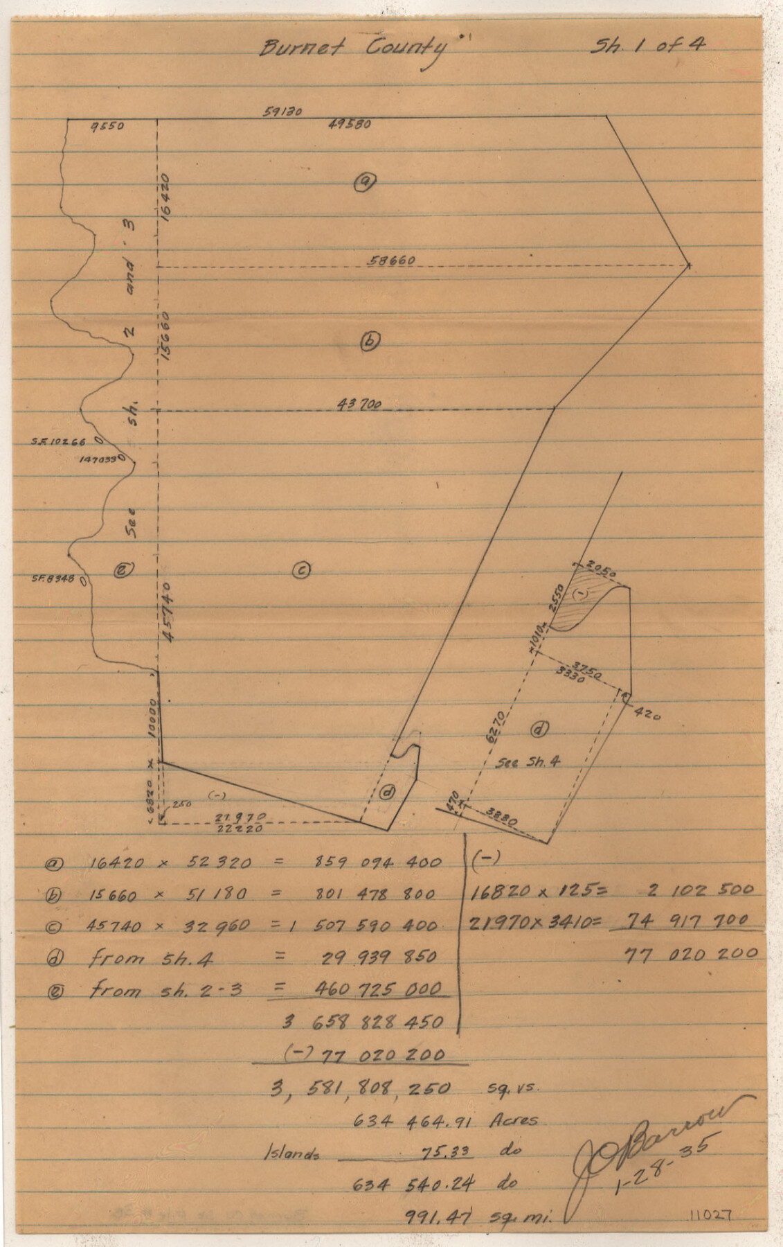
Burnet County Sketch File 38
[Calculations for area of Burnet County]
-
Map/Doc
11027
-
Collection
General Map Collection
-
Object Dates
1935/1/28 (Creation Date)
-
People and Organizations
J.O. Barrow (Surveyor/Engineer)
-
Counties
Burnet
-
Subjects
Surveying Sketch File
-
Height x Width
37.8 x 24.5 inches
96.0 x 62.2 cm
-
Medium
paper, manuscript
Part of: General Map Collection
Flight Mission No. CUG-3P, Frame 134, Kleberg County

Print $20.00
- Digital $50.00
Flight Mission No. CUG-3P, Frame 134, Kleberg County
1956
Size 18.5 x 22.3 inches
Map/Doc 86269
Harris County NRC Article 33.136 Sketch 6

Print $21.00
- Digital $50.00
Harris County NRC Article 33.136 Sketch 6
2003
Size 23.1 x 34.8 inches
Map/Doc 78664
Leon County Working Sketch 17

Print $20.00
- Digital $50.00
Leon County Working Sketch 17
1959
Size 30.8 x 30.5 inches
Map/Doc 70416
Houston County Rolled Sketch 3

Print $57.00
- Digital $50.00
Houston County Rolled Sketch 3
1935
Size 23.5 x 23.4 inches
Map/Doc 6226
Map showing survey for proposed ship channel from Brownsville to Brazos Santiago Pass

Print $20.00
- Digital $50.00
Map showing survey for proposed ship channel from Brownsville to Brazos Santiago Pass
1912
Size 18.2 x 26.9 inches
Map/Doc 72898
Crane County Sketch File 3c

Print $6.00
- Digital $50.00
Crane County Sketch File 3c
1884
Size 12.8 x 7.9 inches
Map/Doc 19559
Val Verde County Sketch File XXX2

Print $20.00
- Digital $50.00
Val Verde County Sketch File XXX2
Size 18.6 x 17.9 inches
Map/Doc 12548
Brazoria County Rolled Sketch 32

Print $20.00
- Digital $50.00
Brazoria County Rolled Sketch 32
Size 29.1 x 22.6 inches
Map/Doc 5170
Harris County Sketch File 21

Print $4.00
- Digital $50.00
Harris County Sketch File 21
1862
Size 13.1 x 8.2 inches
Map/Doc 25373
Flight Mission No. DQN-1K, Frame 50, Calhoun County

Print $20.00
- Digital $50.00
Flight Mission No. DQN-1K, Frame 50, Calhoun County
1953
Size 18.7 x 22.3 inches
Map/Doc 84150
Culberson County Working Sketch 80

Print $40.00
- Digital $50.00
Culberson County Working Sketch 80
1978
Size 56.4 x 43.4 inches
Map/Doc 68534
Calhoun County

Print $20.00
- Digital $50.00
Calhoun County
1883
Size 22.9 x 19.1 inches
Map/Doc 66741
You may also like
G. C. & S. F. Ry. Alinement [sic] and Right of Way Map of Dallas Branch, Johnson County, Texas
![64652, G. C. & S. F. Ry. Alinement [sic] and Right of Way Map of Dallas Branch, Johnson County, Texas, General Map Collection](https://historictexasmaps.com/wmedia_w700/maps/64652.tif.jpg)
Print $40.00
- Digital $50.00
G. C. & S. F. Ry. Alinement [sic] and Right of Way Map of Dallas Branch, Johnson County, Texas
1925
Size 37.6 x 87.9 inches
Map/Doc 64652
Hudspeth County Working Sketch 14

Print $20.00
- Digital $50.00
Hudspeth County Working Sketch 14
1953
Size 24.2 x 41.2 inches
Map/Doc 66296
Anderson County Working Sketch 41

Print $20.00
- Digital $50.00
Anderson County Working Sketch 41
1956
Size 19.2 x 20.5 inches
Map/Doc 67041
Right of Way and Track Map, Galveston, Harrisburg & San Antonio Ry. operated by the T. & N. O. R.R. Co., Victoria Division, Rosenberg to Beeville

Print $40.00
- Digital $50.00
Right of Way and Track Map, Galveston, Harrisburg & San Antonio Ry. operated by the T. & N. O. R.R. Co., Victoria Division, Rosenberg to Beeville
1918
Size 24.8 x 56.4 inches
Map/Doc 76164
[Sketch showing parts of PSL Bloks Q, L, and P]
![89687, [Sketch showing parts of PSL Bloks Q, L, and P], Twichell Survey Records](https://historictexasmaps.com/wmedia_w700/maps/89687-1.tif.jpg)
Print $40.00
- Digital $50.00
[Sketch showing parts of PSL Bloks Q, L, and P]
Size 62.4 x 23.2 inches
Map/Doc 89687

Liberty County Sketch File 50

Print $42.00
- Digital $50.00
Liberty County Sketch File 50
1879
Size 12.6 x 8.4 inches
Map/Doc 30014
Sutton County Working Sketch 6

Print $20.00
- Digital $50.00
Sutton County Working Sketch 6
1972
Size 39.3 x 37.4 inches
Map/Doc 62349
Crosby County Sketch File 13 and 14

Print $44.00
- Digital $50.00
Crosby County Sketch File 13 and 14
1904
Size 9.0 x 8.6 inches
Map/Doc 20058
Hutchinson County Rolled Sketch 40

Print $20.00
- Digital $50.00
Hutchinson County Rolled Sketch 40
1981
Size 26.1 x 37.5 inches
Map/Doc 6298
Gonzales County

Print $20.00
- Digital $50.00
Gonzales County
1871
Size 17.2 x 25.8 inches
Map/Doc 3593
Webb County Working Sketch 10

Print $20.00
- Digital $50.00
Webb County Working Sketch 10
1913
Size 23.7 x 20.0 inches
Map/Doc 72375