Kinney County Sketch File A1
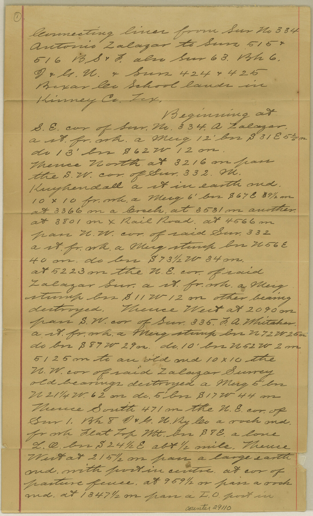
[Sketch and field notes of connecting lines from survey no. 334, Antonio Zalazar to surveys 515 and 516, B. S. & F. also survey 63, Block 6, I. & G. N. and surveys 424 and 425, Bexar County School Lands]
-
Map/Doc
11952
-
Collection
General Map Collection
-
Object Dates
2/24/1905 (Creation Date)
3/17/1905 (File Date)
1/30/1906 (Creation Date)
-
People and Organizations
C.F. Hodges (Surveyor/Engineer)
-
Counties
Kinney
-
Subjects
Surveying Sketch File
-
Height x Width
35.4 x 27.6 inches
89.9 x 70.1 cm
-
Medium
paper, manuscript
-
Features
San Antonio and El Paso Road
Part of: General Map Collection
Jackson County Sketch File 3

Print $34.00
- Digital $50.00
Jackson County Sketch File 3
1875
Size 7.9 x 7.7 inches
Map/Doc 27621
Stephens County Working Sketch 25

Print $20.00
- Digital $50.00
Stephens County Working Sketch 25
1976
Size 37.4 x 32.3 inches
Map/Doc 63968
Brazoria County NRC Article 33.136 Sketch 27

Print $24.00
Brazoria County NRC Article 33.136 Sketch 27
2025
Map/Doc 97472
San Patricio County Working Sketch 13

Print $20.00
- Digital $50.00
San Patricio County Working Sketch 13
1949
Size 38.8 x 38.6 inches
Map/Doc 63775
Runnels County Working Sketch 22

Print $20.00
- Digital $50.00
Runnels County Working Sketch 22
1951
Size 16.2 x 28.1 inches
Map/Doc 63618
[Surveys along the Neches River in Jasper District]
![69733, [Surveys along the Neches River in Jasper District], General Map Collection](https://historictexasmaps.com/wmedia_w700/maps/69733.tif.jpg)
Print $2.00
- Digital $50.00
[Surveys along the Neches River in Jasper District]
1847
Size 9.2 x 6.8 inches
Map/Doc 69733
Moore County Sketch File 10

Print $20.00
- Digital $50.00
Moore County Sketch File 10
1910
Size 18.7 x 30.1 inches
Map/Doc 42128

Florida et Apalche

Print $20.00
- Digital $50.00
Florida et Apalche
1597
Size 11.2 x 14.4 inches
Map/Doc 94076
Sabine River, Merrill Lake Sheet

Print $20.00
- Digital $50.00
Sabine River, Merrill Lake Sheet
1933
Size 26.4 x 43.6 inches
Map/Doc 65137
McCulloch County Sketch File 9

Print $6.00
- Digital $50.00
McCulloch County Sketch File 9
1883
Size 7.3 x 8.7 inches
Map/Doc 31184
Dickens County Sketch File 23

Print $6.00
- Digital $50.00
Dickens County Sketch File 23
1914
Size 12.4 x 8.4 inches
Map/Doc 20990
You may also like
Donley County Rolled Sketch 2

Print $20.00
- Digital $50.00
Donley County Rolled Sketch 2
Size 41.8 x 34.3 inches
Map/Doc 8800
[I. & G. N. RR. Co. Blk. 6, Blks M8, M9 and M10]
![90267, [I. & G. N. RR. Co. Blk. 6, Blks M8, M9 and M10], Twichell Survey Records](https://historictexasmaps.com/wmedia_w700/maps/90267-1.tif.jpg)
Print $20.00
- Digital $50.00
[I. & G. N. RR. Co. Blk. 6, Blks M8, M9 and M10]
Size 34.2 x 20.3 inches
Map/Doc 90267
Zavala County Rolled Sketch 20

Print $20.00
- Digital $50.00
Zavala County Rolled Sketch 20
Size 33.9 x 26.3 inches
Map/Doc 8323
Childress County Sketch File 19

Print $4.00
- Digital $50.00
Childress County Sketch File 19
Size 14.1 x 8.7 inches
Map/Doc 18294
Cochran County Boundary File 2

Print $59.00
- Digital $50.00
Cochran County Boundary File 2
Size 14.8 x 9.3 inches
Map/Doc 51466
Lee County Working Sketch 3

Print $20.00
- Digital $50.00
Lee County Working Sketch 3
1968
Size 37.9 x 37.3 inches
Map/Doc 70382
Wichita County Rolled Sketch 13

Print $20.00
- Digital $50.00
Wichita County Rolled Sketch 13
Size 25.7 x 16.6 inches
Map/Doc 8250
Flight Mission No. BRA-16M, Frame 66, Jefferson County

Print $20.00
- Digital $50.00
Flight Mission No. BRA-16M, Frame 66, Jefferson County
1953
Size 18.6 x 22.3 inches
Map/Doc 85683
Lamar County Boundary File 56a

Print $34.00
- Digital $50.00
Lamar County Boundary File 56a
Size 8.7 x 14.3 inches
Map/Doc 56020
Flight Mission No. DAG-19K, Frame 62, Matagorda County

Print $20.00
- Digital $50.00
Flight Mission No. DAG-19K, Frame 62, Matagorda County
1952
Size 16.2 x 16.1 inches
Map/Doc 86389
Schleicher County Sketch File 8

Print $32.00
- Digital $50.00
Schleicher County Sketch File 8
1881
Size 12.5 x 8.2 inches
Map/Doc 36479
Callahan County Rolled Sketch 25

Print $20.00
- Digital $50.00
Callahan County Rolled Sketch 25
1974
Size 18.4 x 22.5 inches
Map/Doc 5383