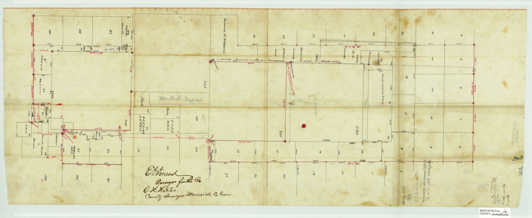
Maverick County Sketch File 16
[Sketch of Leagues 230, 231, 232 & 233 and surrounding area]
-
Map/Doc
12051
-
Collection
General Map Collection
-
Object Dates
3/25/1887 (Creation Date)
-
People and Organizations
E.A. Giraud (Surveyor/Engineer)
O.H. Hector ()
-
Counties
Maverick
-
Subjects
Surveying Sketch File
-
Height x Width
14.1 x 34.5 inches
35.8 x 87.6 cm
-
Medium
paper, manuscript
Part of: General Map Collection
Rockwall County Sketch File 5

Print $6.00
Rockwall County Sketch File 5
1861
Size 13.0 x 8.3 inches
Map/Doc 35422
United States - Gulf Coast - Galveston to Rio Grande

Print $20.00
- Digital $50.00
United States - Gulf Coast - Galveston to Rio Grande
1941
Size 26.6 x 18.5 inches
Map/Doc 72752
Ellis County Working Sketch 2

Print $20.00
- Digital $50.00
Ellis County Working Sketch 2
1947
Size 27.0 x 25.6 inches
Map/Doc 69018
San Jacinto County Working Sketch 19

Print $20.00
- Digital $50.00
San Jacinto County Working Sketch 19
1939
Size 25.4 x 25.2 inches
Map/Doc 63732
Zapata County Working Sketch 14

Print $20.00
- Digital $50.00
Zapata County Working Sketch 14
1962
Size 44.5 x 40.4 inches
Map/Doc 62065
Chambers County Boundary File 4

Print $34.00
- Digital $50.00
Chambers County Boundary File 4
1909
Size 9.1 x 3.9 inches
Map/Doc 51259
Harris County Rolled Sketch 85

Print $20.00
- Digital $50.00
Harris County Rolled Sketch 85
1968
Size 22.0 x 32.0 inches
Map/Doc 6119
Eastland County Sketch File 14

Print $8.00
- Digital $50.00
Eastland County Sketch File 14
Size 11.5 x 9.2 inches
Map/Doc 21595
Henderson County Working Sketch 17

Print $20.00
- Digital $50.00
Henderson County Working Sketch 17
1937
Size 27.3 x 27.4 inches
Map/Doc 66150
Lipscomb County Boundary File 7

Print $4.00
- Digital $50.00
Lipscomb County Boundary File 7
Size 6.6 x 8.1 inches
Map/Doc 56331
Pecos County Sketch File 28a

Print $14.00
- Digital $50.00
Pecos County Sketch File 28a
1911
Size 14.5 x 8.9 inches
Map/Doc 33683
Harris County Sketch File 86

Print $20.00
- Digital $50.00
Harris County Sketch File 86
1894
Size 34.7 x 21.3 inches
Map/Doc 11674
You may also like
Lubbock County Working Sketch 2

Print $20.00
- Digital $50.00
Lubbock County Working Sketch 2
Size 31.7 x 21.4 inches
Map/Doc 70661
Parmer County

Print $20.00
- Digital $50.00
Parmer County
1926
Size 46.2 x 36.5 inches
Map/Doc 66973
Graham's Addition Being a Subdivision of a Portion of Lot No. 1 of Spear League

Print $20.00
- Digital $50.00
Graham's Addition Being a Subdivision of a Portion of Lot No. 1 of Spear League
1914
Size 13.6 x 33.0 inches
Map/Doc 542
Map of Bailey County, Texas

Print $20.00
- Digital $50.00
Map of Bailey County, Texas
1912
Size 15.8 x 19.8 inches
Map/Doc 90248
Camp County Working Sketch Graphic Index

Print $20.00
- Digital $50.00
Camp County Working Sketch Graphic Index
1942
Size 25.1 x 29.7 inches
Map/Doc 76487
Chambers County Sketch File 26

Print $20.00
- Digital $50.00
Chambers County Sketch File 26
1934
Size 19.6 x 24.6 inches
Map/Doc 11066
Pecos County Sketch File 34

Print $4.00
- Digital $50.00
Pecos County Sketch File 34
Size 11.1 x 8.5 inches
Map/Doc 33714
Reagan County Rolled Sketch 34

Print $40.00
- Digital $50.00
Reagan County Rolled Sketch 34
1956
Size 53.2 x 40.3 inches
Map/Doc 9829
Stonewall County Sketch File 26

Print $20.00
- Digital $50.00
Stonewall County Sketch File 26
1953
Size 35.7 x 36.8 inches
Map/Doc 10376
Wilson County Rolled Sketch 1

Print $20.00
- Digital $50.00
Wilson County Rolled Sketch 1
1941
Size 31.5 x 27.1 inches
Map/Doc 8367
Brewster County Working Sketch 3

Print $20.00
- Digital $50.00
Brewster County Working Sketch 3
1908
Size 26.4 x 19.4 inches
Map/Doc 67536
Taylor County Sketch File 13

Print $8.00
- Digital $50.00
Taylor County Sketch File 13
1913
Size 9.1 x 8.5 inches
Map/Doc 37798