San Patricio County Sketch File 17
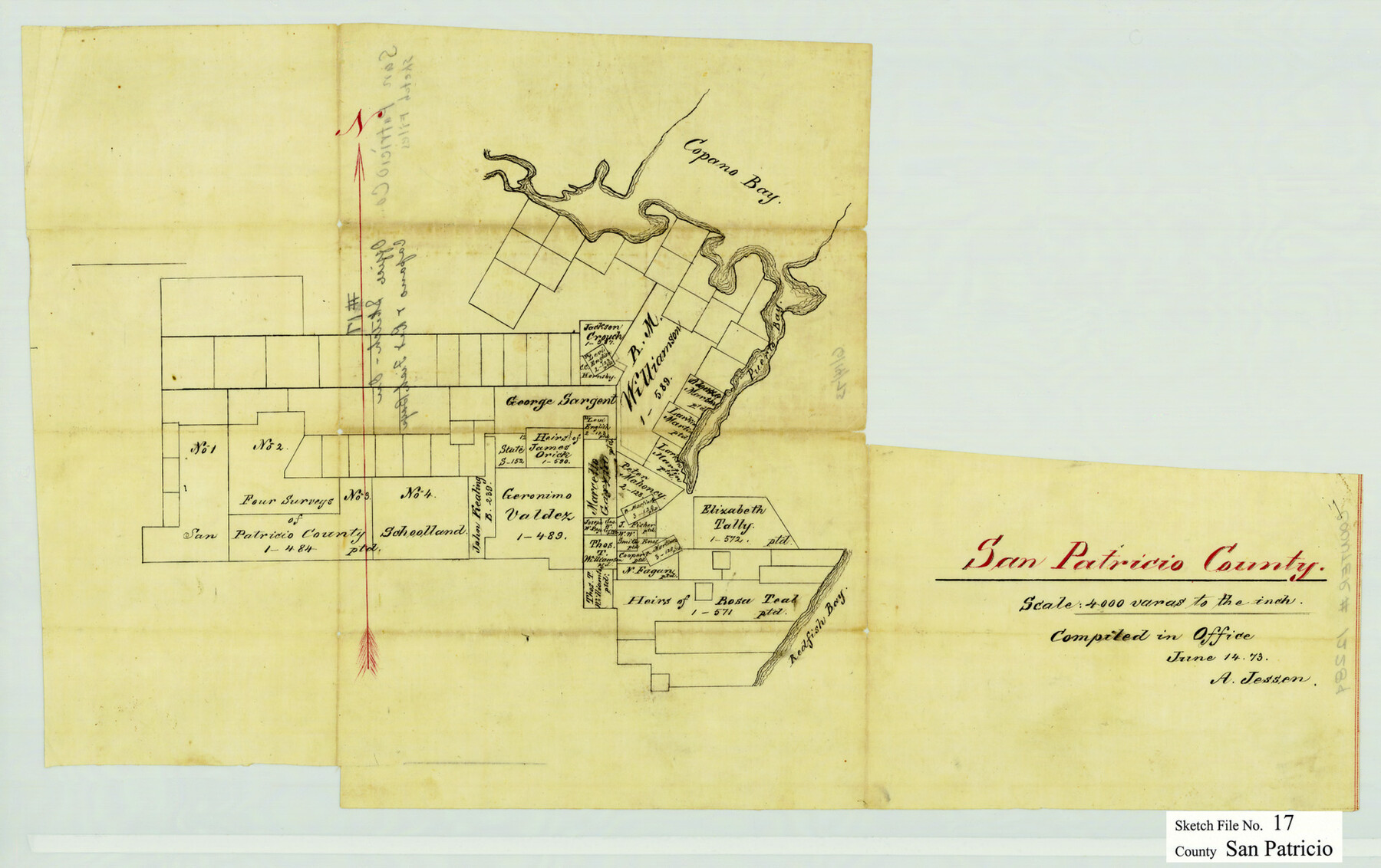
[Sketch showing surveys along the coast in San Patricio County and Aransas County]
-
Map/Doc
12284
-
Collection
General Map Collection
-
Object Dates
6/14/1873 (Creation Date)
-
People and Organizations
A. Jessen (Compiler)
-
Counties
San Patricio Aransas
-
Subjects
Surveying Sketch File
-
Height x Width
12.0 x 19.0 inches
30.5 x 48.3 cm
-
Medium
paper, manuscript
-
Scale
1" = 4000 varas
-
Features
Copano Bay
Puerto Bay
Redfish Bay
Part of: General Map Collection
Crockett County Rolled Sketch 64

Print $20.00
- Digital $50.00
Crockett County Rolled Sketch 64
1947
Size 19.8 x 41.2 inches
Map/Doc 5607
Map Shelby County

Print $20.00
- Digital $50.00
Map Shelby County
1852
Size 20.1 x 31.5 inches
Map/Doc 4029
Freestone County Sketch File 4

Print $6.00
- Digital $50.00
Freestone County Sketch File 4
1848
Size 10.8 x 8.2 inches
Map/Doc 23044
Presidio County Sketch File 87

Print $6.00
- Digital $50.00
Presidio County Sketch File 87
1951
Size 14.5 x 8.7 inches
Map/Doc 34748
Smith County Rolled Sketch 6B

Print $40.00
- Digital $50.00
Smith County Rolled Sketch 6B
1949
Size 91.7 x 38.5 inches
Map/Doc 10700
Georgetown and the City of Washington the Capital of the United States of America

Print $20.00
- Digital $50.00
Georgetown and the City of Washington the Capital of the United States of America
1856
Size 15.7 x 18.7 inches
Map/Doc 95359
Houston County Rolled Sketch 10

Print $20.00
- Digital $50.00
Houston County Rolled Sketch 10
1988
Size 31.9 x 25.3 inches
Map/Doc 6230
Hays County Working Sketch 15

Print $40.00
- Digital $50.00
Hays County Working Sketch 15
1965
Size 39.8 x 51.6 inches
Map/Doc 66089
Leon County Sketch File 14

Print $6.00
- Digital $50.00
Leon County Sketch File 14
Size 13.2 x 8.8 inches
Map/Doc 29767
Bowie County Working Sketch 20

Print $20.00
- Digital $50.00
Bowie County Working Sketch 20
1965
Size 33.0 x 31.9 inches
Map/Doc 67424
Hockley County

Print $20.00
- Digital $50.00
Hockley County
1914
Size 27.4 x 22.8 inches
Map/Doc 4686
Eastland County Working Sketch 7

Print $3.00
- Digital $50.00
Eastland County Working Sketch 7
1918
Size 15.6 x 10.7 inches
Map/Doc 68788
You may also like
Sabine County Sketch File 4

Print $22.00
Sabine County Sketch File 4
1876
Size 8.1 x 12.8 inches
Map/Doc 35606
Mosaic composed of aerial photographs - Houston Ship Channel, Tex.

Print $20.00
- Digital $50.00
Mosaic composed of aerial photographs - Houston Ship Channel, Tex.
1923
Size 13.7 x 38.0 inches
Map/Doc 97172
Dallas County Sketch File 18

Print $6.00
- Digital $50.00
Dallas County Sketch File 18
1871
Size 15.8 x 11.0 inches
Map/Doc 20437
Lubbock County Sketch File 14

Print $4.00
- Digital $50.00
Lubbock County Sketch File 14
1892
Size 11.2 x 8.9 inches
Map/Doc 30438
Galveston County Sketch File 73

Print $78.00
- Digital $50.00
Galveston County Sketch File 73
1998
Size 11.3 x 8.8 inches
Map/Doc 23980
El Paso County Working Sketch 6

Print $20.00
- Digital $50.00
El Paso County Working Sketch 6
1928
Size 25.4 x 16.7 inches
Map/Doc 69028
Current Miscellaneous File 101

Print $46.00
- Digital $50.00
Current Miscellaneous File 101
1931
Size 8.8 x 14.2 inches
Map/Doc 74357
Flight Mission No. BRE-1P, Frame 33, Nueces County

Print $20.00
- Digital $50.00
Flight Mission No. BRE-1P, Frame 33, Nueces County
1956
Size 18.5 x 22.2 inches
Map/Doc 86629
Hunt County Working Sketch 2

Print $20.00
- Digital $50.00
Hunt County Working Sketch 2
Size 20.5 x 16.5 inches
Map/Doc 66349
Borden County Working Sketch 14

Print $20.00
- Digital $50.00
Borden County Working Sketch 14
1959
Size 27.8 x 25.2 inches
Map/Doc 67474
Maps of Gulf Intracoastal Waterway, Texas - Sabine River to the Rio Grande and connecting waterways including ship channels

Print $20.00
- Digital $50.00
Maps of Gulf Intracoastal Waterway, Texas - Sabine River to the Rio Grande and connecting waterways including ship channels
1966
Size 14.6 x 22.2 inches
Map/Doc 61939
Cooke County Working Sketch 34

Print $20.00
- Digital $50.00
Cooke County Working Sketch 34
1984
Size 41.7 x 38.0 inches
Map/Doc 68271