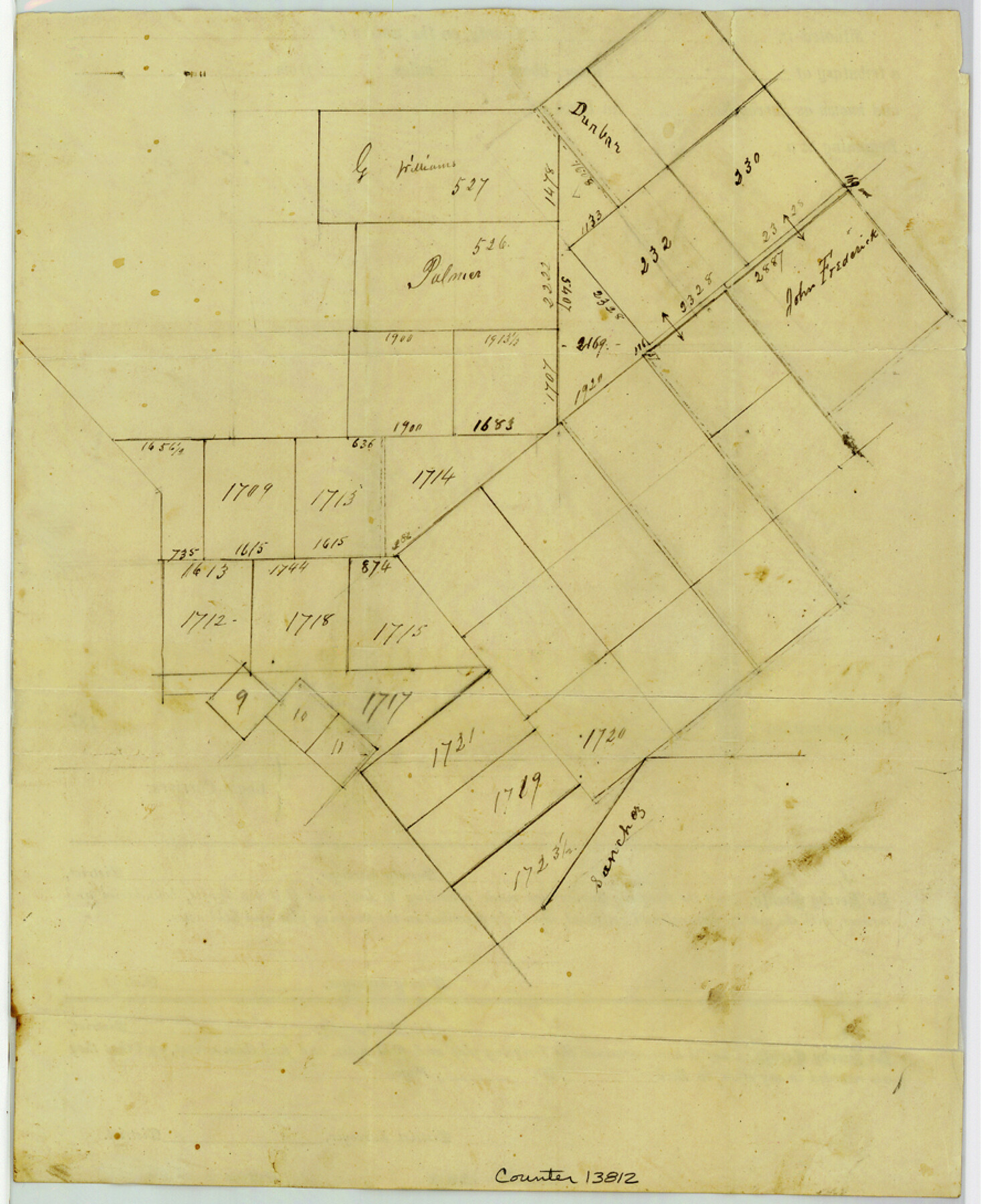
Atascosa County Sketch File 27d
[Surveyor's letter and sketch of surveys southeast of Jourdanton]
-
Map/Doc
13812
-
Collection
General Map Collection
-
Object Dates
1876/1/26 (Creation Date)
-
People and Organizations
Enoch Moore (Surveyor/Engineer)
-
Counties
Atascosa
-
Subjects
Surveying Sketch File
-
Height x Width
10.9 x 8.9 inches
27.7 x 22.6 cm
-
Medium
paper, manuscript
Part of: General Map Collection
Flight Mission No. CLL-1N, Frame 82, Willacy County

Print $20.00
- Digital $50.00
Flight Mission No. CLL-1N, Frame 82, Willacy County
1954
Size 18.3 x 22.1 inches
Map/Doc 87028
Location Survey of the Southern Kansas Railway, Kiowa Extension from a point in Drake's Location, in Indian Territory 100 miles from south line of Kansas, continuing up Wolf Creek and South Canadian River to Cottonwood Creek in Hutchinson County

Print $40.00
- Digital $50.00
Location Survey of the Southern Kansas Railway, Kiowa Extension from a point in Drake's Location, in Indian Territory 100 miles from south line of Kansas, continuing up Wolf Creek and South Canadian River to Cottonwood Creek in Hutchinson County
1886
Size 37.5 x 282.7 inches
Map/Doc 88837
Loving County Rolled Sketch 19

Print $20.00
- Digital $50.00
Loving County Rolled Sketch 19
2020
Size 24.4 x 35.3 inches
Map/Doc 96575
Aransas Pass to Baffin Bay

Print $20.00
- Digital $50.00
Aransas Pass to Baffin Bay
1966
Size 42.3 x 35.0 inches
Map/Doc 73415
PSL Field Notes for Blocks 60, 61, 62, 83, 84, 85, 88, 89, 90, 91, 92, and 93 in Culberson County

PSL Field Notes for Blocks 60, 61, 62, 83, 84, 85, 88, 89, 90, 91, 92, and 93 in Culberson County
Map/Doc 81667
Pecos County Sketch File 35

Print $4.00
- Digital $50.00
Pecos County Sketch File 35
Size 8.9 x 15.3 inches
Map/Doc 33716
El Paso County Boundary File 22

Print $4.00
- Digital $50.00
El Paso County Boundary File 22
Size 13.6 x 8.6 inches
Map/Doc 53216
Corpus Christi Pass, Texas

Print $3.00
- Digital $50.00
Corpus Christi Pass, Texas
1869
Size 16.7 x 11.2 inches
Map/Doc 73456

[University Lands in West Texas]
![2422, [University Lands in West Texas], General Map Collection](https://historictexasmaps.com/wmedia_w700/maps/2422.tif.jpg)
Print $20.00
- Digital $50.00
[University Lands in West Texas]
1938
Size 20.3 x 28.1 inches
Map/Doc 2422
Trinity County

Print $20.00
- Digital $50.00
Trinity County
1946
Size 42.7 x 43.2 inches
Map/Doc 95656
Tabular exhibit of the land occupied by the roadbed of the Galveston, Harrisburg and San Antonio Railway in El Paso County, Texas

Print $20.00
- Digital $50.00
Tabular exhibit of the land occupied by the roadbed of the Galveston, Harrisburg and San Antonio Railway in El Paso County, Texas
Size 12.7 x 8.2 inches
Map/Doc 64499
You may also like
City of Plainview, Hale County, Texas

Print $40.00
- Digital $50.00
City of Plainview, Hale County, Texas
Size 43.5 x 53.3 inches
Map/Doc 89841
Throckmorton County Working Sketch 5

Print $20.00
- Digital $50.00
Throckmorton County Working Sketch 5
1927
Size 31.8 x 24.4 inches
Map/Doc 62114
Fort Bend County Working Sketch 7

Print $20.00
- Digital $50.00
Fort Bend County Working Sketch 7
1918
Size 20.6 x 30.7 inches
Map/Doc 69213
Brazoria County NRC Article 33.136 Sketch 31

Print $24.00
Brazoria County NRC Article 33.136 Sketch 31
2025
Map/Doc 97476
Brazos River Conservation and Reclamation District Official Boundary Line Survey

Print $20.00
- Digital $50.00
Brazos River Conservation and Reclamation District Official Boundary Line Survey
1931
Size 25.1 x 36.9 inches
Map/Doc 90125
Map of the United States of America for Goddard's "Where to Emigrate and Why"

Print $20.00
- Digital $50.00
Map of the United States of America for Goddard's "Where to Emigrate and Why"
1869
Size 12.4 x 18.8 inches
Map/Doc 96619
[Blocks B10 and 6T]
![91511, [Blocks B10 and 6T], Twichell Survey Records](https://historictexasmaps.com/wmedia_w700/maps/91511-1.tif.jpg)
Print $20.00
- Digital $50.00
[Blocks B10 and 6T]
Size 21.0 x 7.5 inches
Map/Doc 91511
Intracoastal Waterway - Galveston Bay to West Bay including Galveston Bay Entrance

Print $20.00
- Digital $50.00
Intracoastal Waterway - Galveston Bay to West Bay including Galveston Bay Entrance
1957
Size 27.2 x 38.6 inches
Map/Doc 69933
Garza County Sketch File 26

Print $4.00
- Digital $50.00
Garza County Sketch File 26
Size 10.9 x 8.5 inches
Map/Doc 24095
Sutton County Working Sketch 29

Print $20.00
- Digital $50.00
Sutton County Working Sketch 29
1917
Size 15.8 x 13.6 inches
Map/Doc 62372
Dimmit County Rolled Sketch 20A

Print $20.00
- Digital $50.00
Dimmit County Rolled Sketch 20A
1999
Size 24.9 x 36.5 inches
Map/Doc 6065
Randall County Rolled Sketch 8

Print $20.00
- Digital $50.00
Randall County Rolled Sketch 8
1975
Size 33.7 x 43.7 inches
Map/Doc 10620