Bastrop County Sketch File 11
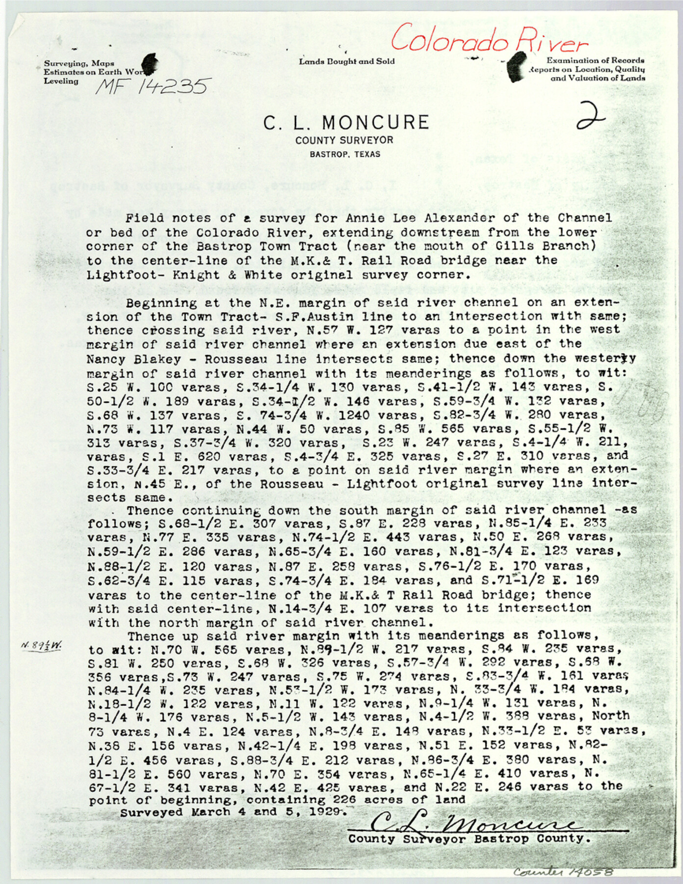
[Copy of field notes and sketch relating to MF-14235 and MF-10303, Colorado River]
-
Map/Doc
14058
-
Collection
General Map Collection
-
Object Dates
1983/6/20 (File Date)
1925/11/12 (Survey Date)
-
People and Organizations
C.L. Moncure (Surveyor/Engineer)
E.J. Robbins (Chainman/Field Personnel)
Bob Lisle (Chainman/Field Personnel)
-
Counties
Bastrop Travis
-
Subjects
Surveying Sketch File
-
Height x Width
11.2 x 8.7 inches
28.4 x 22.1 cm
-
Medium
multi-page, multi-format
-
Features
MK&T Railroad Bridge
Cedar Creek
Colorado River
Bastrop
Part of: General Map Collection
Maverick County Working Sketch 6

Print $40.00
- Digital $50.00
Maverick County Working Sketch 6
1944
Size 55.9 x 42.4 inches
Map/Doc 70898
Pecos County Rolled Sketch 150

Print $20.00
- Digital $50.00
Pecos County Rolled Sketch 150
1958
Size 27.6 x 24.7 inches
Map/Doc 7280
Garza County Sketch File 25a

Print $14.00
- Digital $50.00
Garza County Sketch File 25a
Size 11.4 x 8.8 inches
Map/Doc 24088
Presidio County Rolled Sketch 112

Print $20.00
- Digital $50.00
Presidio County Rolled Sketch 112
1972
Size 22.8 x 36.5 inches
Map/Doc 7388
Crane County Sketch File 2

Print $6.00
- Digital $50.00
Crane County Sketch File 2
1873
Size 17.5 x 11.2 inches
Map/Doc 19557
Fractional Township No. 8 South Range No. 23 East of the Indian Meridian, Indian Territory

Print $20.00
- Digital $50.00
Fractional Township No. 8 South Range No. 23 East of the Indian Meridian, Indian Territory
1898
Size 19.1 x 24.3 inches
Map/Doc 75249
La Salle County Rolled Sketch 11

Print $20.00
- Digital $50.00
La Salle County Rolled Sketch 11
1947
Size 22.1 x 35.8 inches
Map/Doc 6574
Orange County Sketch File 37

Print $8.00
- Digital $50.00
Orange County Sketch File 37
1950
Size 14.2 x 8.8 inches
Map/Doc 33374
Ellis County Boundary File 6

Print $22.00
- Digital $50.00
Ellis County Boundary File 6
Size 8.6 x 6.0 inches
Map/Doc 52992
Hamilton County Rolled Sketch 11

Print $20.00
- Digital $50.00
Hamilton County Rolled Sketch 11
Size 20.1 x 14.1 inches
Map/Doc 6060
Frio County Sketch File 14

Print $8.00
- Digital $50.00
Frio County Sketch File 14
1949
Size 11.2 x 8.7 inches
Map/Doc 23141
Martin County Sketch File 1

Print $66.00
- Digital $50.00
Martin County Sketch File 1
Size 19.3 x 8.9 inches
Map/Doc 30626
You may also like
Map of the Houston & Great Northern Railroad

Print $40.00
- Digital $50.00
Map of the Houston & Great Northern Railroad
1871
Size 29.3 x 122.1 inches
Map/Doc 64551

Tyler County Sketch File 26

Print $26.00
- Digital $50.00
Tyler County Sketch File 26
1955
Size 14.5 x 8.8 inches
Map/Doc 38693
Angelina County Sketch File 13

Print $4.00
- Digital $50.00
Angelina County Sketch File 13
1860
Size 13.0 x 8.2 inches
Map/Doc 12957
McMullen County Working Sketch 14

Print $20.00
- Digital $50.00
McMullen County Working Sketch 14
1938
Size 28.6 x 37.1 inches
Map/Doc 70715
The Republic County of Robertson. January 29, 1842

Print $20.00
The Republic County of Robertson. January 29, 1842
2020
Size 16.9 x 21.7 inches
Map/Doc 96262
Refugio County Working Sketch 10

Print $20.00
- Digital $50.00
Refugio County Working Sketch 10
1941
Size 43.0 x 30.1 inches
Map/Doc 63519
Sterling County Sketch File 25

Print $4.00
- Digital $50.00
Sterling County Sketch File 25
1892
Size 11.1 x 8.9 inches
Map/Doc 37192
Concho County Working Sketch 10

Print $20.00
- Digital $50.00
Concho County Working Sketch 10
1951
Size 21.2 x 15.6 inches
Map/Doc 68192
Ochiltree County Boundary File 5b

Print $4.00
- Digital $50.00
Ochiltree County Boundary File 5b
Size 13.7 x 8.7 inches
Map/Doc 57697
[Blk. B, part of Blk. M, and north line of Morris County School Land]
![90359, [Blk. B, part of Blk. M, and north line of Morris County School Land], Twichell Survey Records](https://historictexasmaps.com/wmedia_w700/maps/90359-1.tif.jpg)
Print $20.00
- Digital $50.00
[Blk. B, part of Blk. M, and north line of Morris County School Land]
Size 23.9 x 22.7 inches
Map/Doc 90359
Marion County Working Sketch 21

Print $20.00
- Digital $50.00
Marion County Working Sketch 21
1958
Size 29.1 x 26.9 inches
Map/Doc 70797