Bosque County Sketch File 30b
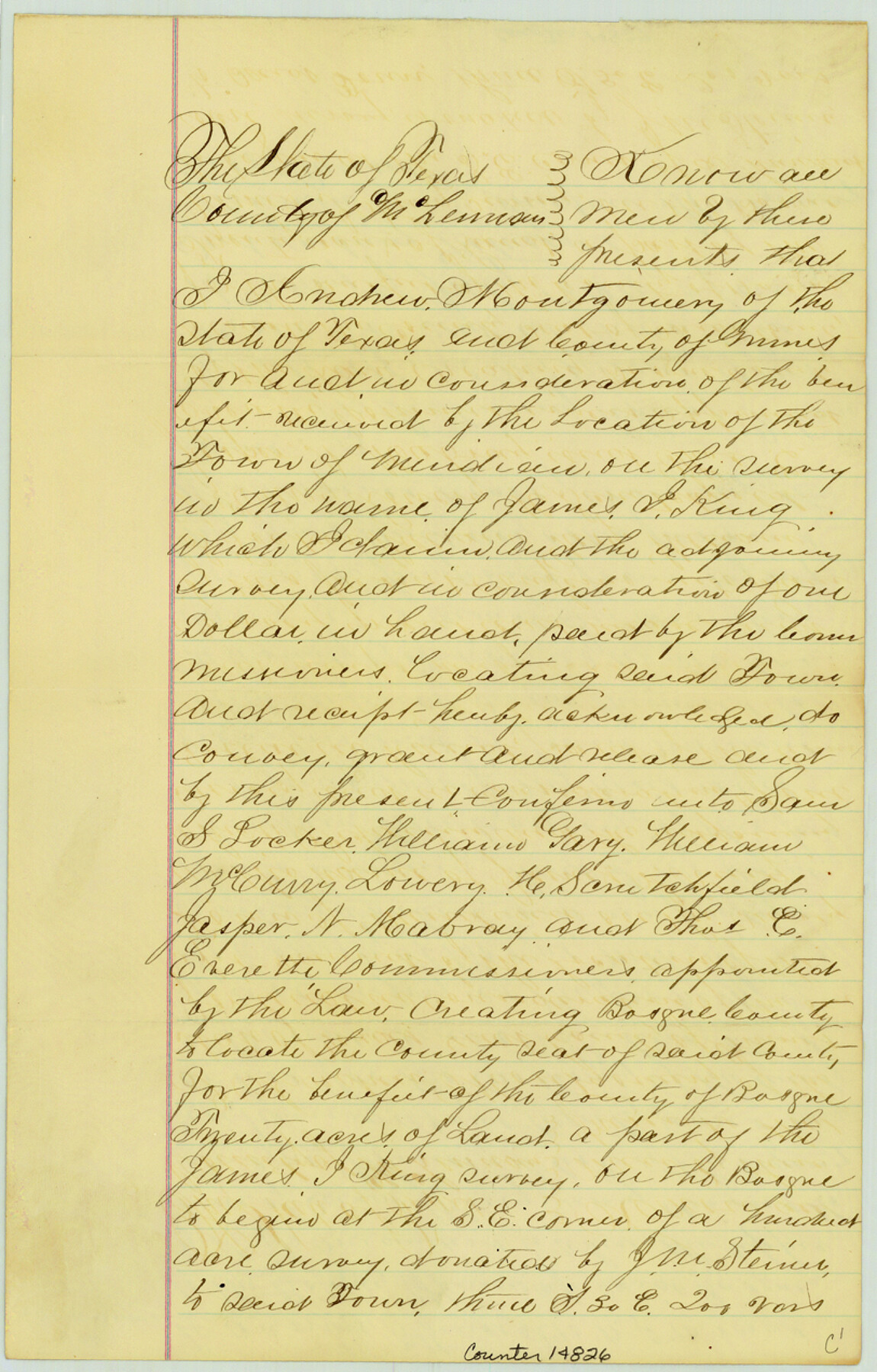
[Copy of deed of 20 acres from Andrew Montgomery to County Commissioners of Bosque County for location of the county seat]
-
Map/Doc
14826
-
Collection
General Map Collection
-
Object Dates
1854/7/15 (Creation Date)
1883/7/8 (File Date)
-
People and Organizations
Andrew Montgomery (Landowner)
-
Counties
Bosque
-
Subjects
Surveying Sketch File
-
Height x Width
12.7 x 8.1 inches
32.3 x 20.6 cm
-
Medium
paper, manuscript
-
Features
Bosque River
Part of: General Map Collection
Harris County Historic Topographic 20

Print $20.00
- Digital $50.00
Harris County Historic Topographic 20
1915
Size 29.3 x 22.6 inches
Map/Doc 65831
Van Zandt County

Print $20.00
- Digital $50.00
Van Zandt County
1972
Size 47.6 x 42.0 inches
Map/Doc 95662
Kendall County Sketch File 5

Print $4.00
- Digital $50.00
Kendall County Sketch File 5
1854
Size 8.7 x 7.6 inches
Map/Doc 28686
Sutton County Working Sketch 53

Print $20.00
- Digital $50.00
Sutton County Working Sketch 53
1957
Size 36.1 x 37.5 inches
Map/Doc 62396
Fractional Township No. 9 South Range No. 2 East of the Indian Meridian, Indian Territory

Print $20.00
- Digital $50.00
Fractional Township No. 9 South Range No. 2 East of the Indian Meridian, Indian Territory
1898
Size 19.1 x 24.2 inches
Map/Doc 75203
Travis County Appraisal District Plat Map 2_3215

Print $20.00
- Digital $50.00
Travis County Appraisal District Plat Map 2_3215
Size 21.5 x 26.4 inches
Map/Doc 94222
Kerr County Boundary File 3

Print $6.00
- Digital $50.00
Kerr County Boundary File 3
Size 11.3 x 8.8 inches
Map/Doc 55998
Culberson County Working Sketch 59

Print $20.00
- Digital $50.00
Culberson County Working Sketch 59
1974
Size 46.4 x 37.7 inches
Map/Doc 68513
Copy of Surveyor's Field Book, Morris Browning - In Blocks 7, 5 & 4, I&GNRRCo., Hutchinson and Carson Counties, Texas

Print $2.00
- Digital $50.00
Copy of Surveyor's Field Book, Morris Browning - In Blocks 7, 5 & 4, I&GNRRCo., Hutchinson and Carson Counties, Texas
1888
Size 7.0 x 8.8 inches
Map/Doc 62276
Bosque County Working Sketch 14

Print $20.00
- Digital $50.00
Bosque County Working Sketch 14
1962
Size 24.1 x 23.3 inches
Map/Doc 67447
Reagan County

Print $40.00
- Digital $50.00
Reagan County
1940
Size 48.4 x 37.5 inches
Map/Doc 73270
Fisher County Sketch File 9

Print $4.00
- Digital $50.00
Fisher County Sketch File 9
1893
Size 11.1 x 8.5 inches
Map/Doc 22575
You may also like
Nautical Chart 11332 - Intracoastal Waterway - Galveston Bay to Cedar Lakes

Print $40.00
- Digital $50.00
Nautical Chart 11332 - Intracoastal Waterway - Galveston Bay to Cedar Lakes
1984
Size 22.3 x 60.3 inches
Map/Doc 69940
San Jacinto River and Tributaries, Texas - Survey of 1939

Print $20.00
- Digital $50.00
San Jacinto River and Tributaries, Texas - Survey of 1939
1939
Size 27.7 x 40.5 inches
Map/Doc 60310
Sterling County Sketch File 17a

Print $20.00
- Digital $50.00
Sterling County Sketch File 17a
Size 42.8 x 31.6 inches
Map/Doc 10609
Wise County Working Sketch 1

Print $20.00
- Digital $50.00
Wise County Working Sketch 1
1929
Size 22.4 x 19.4 inches
Map/Doc 72615
Flight Mission No. CLL-1N, Frame 157, Willacy County

Print $20.00
- Digital $50.00
Flight Mission No. CLL-1N, Frame 157, Willacy County
1954
Size 18.3 x 22.0 inches
Map/Doc 87048
Padre Island National Seashore

Print $4.00
- Digital $50.00
Padre Island National Seashore
Size 16.0 x 22.3 inches
Map/Doc 60532
Maverick County Sketch File 10a

Print $19.00
- Digital $50.00
Maverick County Sketch File 10a
1878
Size 15.4 x 10.0 inches
Map/Doc 31083
Railroad and County Map of Texas

Print $20.00
- Digital $50.00
Railroad and County Map of Texas
1926
Size 42.9 x 45.2 inches
Map/Doc 65799
Plat of Land Purchased by C. W. Post in Hockley County, Texas

Print $20.00
- Digital $50.00
Plat of Land Purchased by C. W. Post in Hockley County, Texas
1913
Size 24.1 x 14.5 inches
Map/Doc 91116
Lynn County Boundary File 5

Print $18.00
- Digital $50.00
Lynn County Boundary File 5
Size 10.2 x 8.3 inches
Map/Doc 56630
Fayette County Boundary File 1

Print $2.00
- Digital $50.00
Fayette County Boundary File 1
Size 11.1 x 8.7 inches
Map/Doc 53330
[Right of Way & Track Map, The Texas & Pacific Ry. Co. Main Line]
![64659, [Right of Way & Track Map, The Texas & Pacific Ry. Co. Main Line], General Map Collection](https://historictexasmaps.com/wmedia_w700/maps/64659.tif.jpg)
Print $20.00
- Digital $50.00
[Right of Way & Track Map, The Texas & Pacific Ry. Co. Main Line]
Size 11.0 x 18.4 inches
Map/Doc 64659