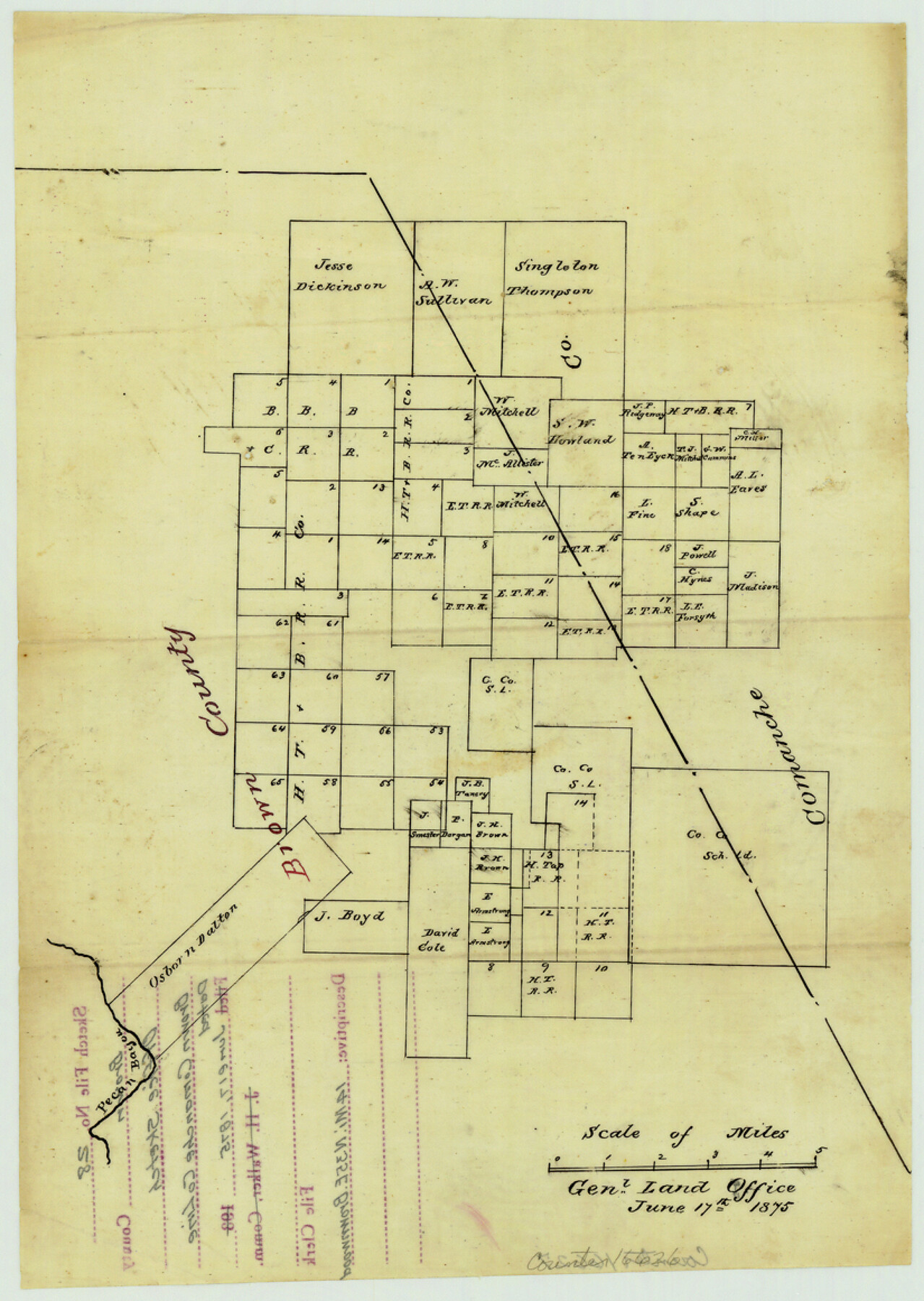
Brown County Sketch File 28
[Office sketch of area along Brown-Comanche County Line]
-
Map/Doc
16626
-
Collection
General Map Collection
-
Object Dates
1875/6/17 (Creation Date)
-
Counties
Brown Comanche
-
Subjects
Surveying Sketch File
-
Height x Width
11.6 x 8.3 inches
29.5 x 21.1 cm
-
Medium
paper, manuscript
-
Features
Pecan Bayou
Part of: General Map Collection
Crockett County Working Sketch 81

Print $20.00
- Digital $50.00
Crockett County Working Sketch 81
1973
Size 28.1 x 37.7 inches
Map/Doc 68414

Rains County Sketch File 9

Print $20.00
- Digital $50.00
Rains County Sketch File 9
Size 14.2 x 16.3 inches
Map/Doc 34960
Starr County Working Sketch 2

Print $20.00
- Digital $50.00
Starr County Working Sketch 2
1916
Size 12.0 x 37.0 inches
Map/Doc 63918
Crosby County Sketch File B

Print $20.00
- Digital $50.00
Crosby County Sketch File B
1877
Size 21.9 x 21.0 inches
Map/Doc 11259
Duval County Sketch File 63

Print $4.00
- Digital $50.00
Duval County Sketch File 63
Size 14.5 x 8.9 inches
Map/Doc 21436
Shackelford County Sketch File 17

Print $4.00
Shackelford County Sketch File 17
2009
Size 14.0 x 8.5 inches
Map/Doc 89230
Flight Mission No. CRC-4R, Frame 80, Chambers County

Print $20.00
- Digital $50.00
Flight Mission No. CRC-4R, Frame 80, Chambers County
1956
Size 18.6 x 22.4 inches
Map/Doc 84884
Duval County Rolled Sketch 37

Print $20.00
- Digital $50.00
Duval County Rolled Sketch 37
1952
Size 29.2 x 24.6 inches
Map/Doc 5753
Childress County Boundary File 3

Print $48.00
- Digital $50.00
Childress County Boundary File 3
Size 9.4 x 4.5 inches
Map/Doc 51330
Hill County Boundary File 45c

Print $64.00
- Digital $50.00
Hill County Boundary File 45c
Size 14.5 x 8.8 inches
Map/Doc 54784
Eastland County Working Sketch 14

Print $20.00
- Digital $50.00
Eastland County Working Sketch 14
1919
Size 18.2 x 17.1 inches
Map/Doc 68795
You may also like
Liberty County Working Sketch 30

Print $20.00
- Digital $50.00
Liberty County Working Sketch 30
1943
Size 18.5 x 20.6 inches
Map/Doc 70489
[Washington County RR. Co. Block 1 and Cherokee Iron Furnace Co. Block 1]
![92065, [Washington County RR. Co. Block 1 and Cherokee Iron Furnace Co. Block 1], Twichell Survey Records](https://historictexasmaps.com/wmedia_w700/maps/92065-1.tif.jpg)
Print $20.00
- Digital $50.00
[Washington County RR. Co. Block 1 and Cherokee Iron Furnace Co. Block 1]
1911
Size 22.4 x 25.4 inches
Map/Doc 92065
Parker County Sketch File 7

Print $26.00
- Digital $50.00
Parker County Sketch File 7
1859
Size 12.4 x 7.9 inches
Map/Doc 33533
Flight Mission No. CRE-1R, Frame 132, Jackson County

Print $20.00
- Digital $50.00
Flight Mission No. CRE-1R, Frame 132, Jackson County
1956
Size 16.2 x 16.0 inches
Map/Doc 85340
Andrews County Rolled Sketch 33

Print $40.00
- Digital $50.00
Andrews County Rolled Sketch 33
Size 131.2 x 22.0 inches
Map/Doc 9003
[Various County School Lands]
![89928, [Various County School Lands], Twichell Survey Records](https://historictexasmaps.com/wmedia_w700/maps/89928-1.tif.jpg)
Print $40.00
- Digital $50.00
[Various County School Lands]
Size 57.6 x 42.9 inches
Map/Doc 89928
Henderson County Sketch File 21

Print $20.00
- Digital $50.00
Henderson County Sketch File 21
1941
Size 27.8 x 17.9 inches
Map/Doc 11758
Brewster County Rolled Sketch 86

Print $20.00
- Digital $50.00
Brewster County Rolled Sketch 86
1940
Size 16.1 x 26.4 inches
Map/Doc 5247
The Republic County of Goliad. December 29, 1845

Print $20.00
The Republic County of Goliad. December 29, 1845
2020
Size 17.5 x 21.7 inches
Map/Doc 96152
Mason County Working Sketch 5

Print $20.00
- Digital $50.00
Mason County Working Sketch 5
1935
Size 12.1 x 18.5 inches
Map/Doc 70841
Flight Mission No. DCL-7C, Frame 75, Kenedy County

Print $20.00
- Digital $50.00
Flight Mission No. DCL-7C, Frame 75, Kenedy County
1943
Size 15.3 x 15.2 inches
Map/Doc 86061
Bell County Working Sketch 11

Print $20.00
- Digital $50.00
Bell County Working Sketch 11
1956
Size 31.8 x 24.4 inches
Map/Doc 67351