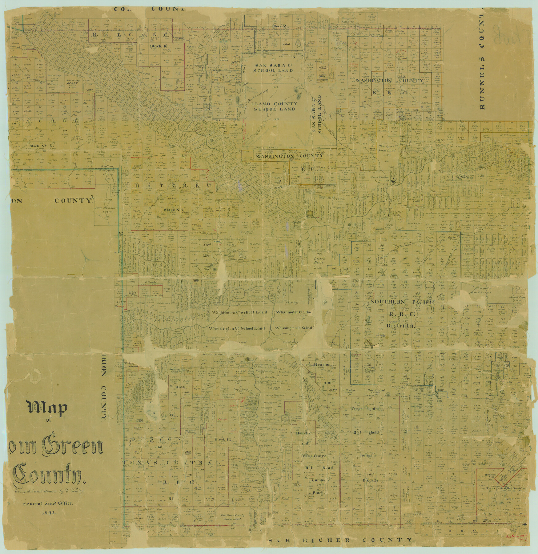
Map of Tom Green County
-
Map/Doc
16898
-
Collection
General Map Collection
-
Object Dates
1892 (Creation Date)
-
People and Organizations
Texas General Land Office (Publisher)
Ed. Schutze (Draftsman)
Ed. Schutze (Compiler)
-
Counties
Tom Green
-
Subjects
County
-
Height x Width
43.8 x 42.6 inches
111.3 x 108.2 cm
-
Comments
Help Save Texas History - Adopt Me!
-
Features
Cottonwood Creek
Kikapoo [sic] Creek
Dove Creek
Antelope Creek
Susan Peak
Knickerbocker
South Concho River
Catelan Creek
Concho River
Erica Creek
Mulberry Creek
Grisby Creek
San Angelo
Bald Eagle Creek
Tom Jeff Creek
Valentine Creek
Round Mountain
North Concho River
Grape Creek
Walnut Creek
Part of: General Map Collection
Parker County Sketch File 48

Print $20.00
- Digital $50.00
Parker County Sketch File 48
1858
Size 17.6 x 22.3 inches
Map/Doc 12152
Coke County Rolled Sketch 24

Print $20.00
- Digital $50.00
Coke County Rolled Sketch 24
Size 35.8 x 33.8 inches
Map/Doc 8633
Smith County Rolled Sketch 2

Print $20.00
- Digital $50.00
Smith County Rolled Sketch 2
Size 36.6 x 35.5 inches
Map/Doc 75931
El Paso County Rolled Sketch 52

Print $20.00
- Digital $50.00
El Paso County Rolled Sketch 52
1929
Size 19.1 x 24.3 inches
Map/Doc 5850
Pecos County Sketch File 60

Print $6.00
- Digital $50.00
Pecos County Sketch File 60
Size 8.2 x 16.5 inches
Map/Doc 33786
Webb County Working Sketch 31

Print $20.00
- Digital $50.00
Webb County Working Sketch 31
1937
Size 23.2 x 26.0 inches
Map/Doc 72396
Panola County Rolled Sketch 1

Print $20.00
- Digital $50.00
Panola County Rolled Sketch 1
Size 17.5 x 23.9 inches
Map/Doc 7196
Flight Mission No. DAG-19K, Frame 65, Matagorda County

Print $20.00
- Digital $50.00
Flight Mission No. DAG-19K, Frame 65, Matagorda County
1952
Size 18.5 x 22.3 inches
Map/Doc 86392
Brazos River, Brazos River Sheet 1

Print $4.00
- Digital $50.00
Brazos River, Brazos River Sheet 1
1926
Size 21.5 x 25.4 inches
Map/Doc 65293
Morris County Rolled Sketch 2A

Print $20.00
- Digital $50.00
Morris County Rolled Sketch 2A
Size 24.0 x 18.8 inches
Map/Doc 10275
Winkler County Rolled Sketch 5

Print $40.00
- Digital $50.00
Winkler County Rolled Sketch 5
1927
Size 58.0 x 38.4 inches
Map/Doc 10148
Map of Cameron, Hidalgo and half of Starr County of Texas

Print $20.00
- Digital $50.00
Map of Cameron, Hidalgo and half of Starr County of Texas
1942
Size 42.1 x 29.6 inches
Map/Doc 60401
You may also like
Wichita Falls, Wichita County, Texas

Print $20.00
- Digital $50.00
Wichita Falls, Wichita County, Texas
Size 32.0 x 22.6 inches
Map/Doc 96791
Map of Uvalde Co.

Print $20.00
- Digital $50.00
Map of Uvalde Co.
1893
Size 42.7 x 42.5 inches
Map/Doc 16911
Burnet County Rolled Sketch 5

Print $40.00
- Digital $50.00
Burnet County Rolled Sketch 5
1971
Size 36.5 x 49.6 inches
Map/Doc 8542
Map of Rotan Fisher County, Texas

Print $20.00
- Digital $50.00
Map of Rotan Fisher County, Texas
1926
Size 32.2 x 36.5 inches
Map/Doc 93231
Ward County Working Sketch 31

Print $40.00
- Digital $50.00
Ward County Working Sketch 31
1967
Size 32.0 x 75.6 inches
Map/Doc 72337
Lavaca County Sketch File 10

Print $4.00
- Digital $50.00
Lavaca County Sketch File 10
1890
Size 7.5 x 11.5 inches
Map/Doc 29648
Gillespie County

Print $40.00
- Digital $50.00
Gillespie County
1887
Size 38.9 x 49.8 inches
Map/Doc 4956
Flight Mission No. CGI-3N, Frame 143, Cameron County

Print $20.00
- Digital $50.00
Flight Mission No. CGI-3N, Frame 143, Cameron County
1954
Size 18.5 x 22.1 inches
Map/Doc 84616
Hopkins County Sketch File 11

Print $4.00
- Digital $50.00
Hopkins County Sketch File 11
Size 7.7 x 7.7 inches
Map/Doc 26704
Flight Mission No. CLL-3N, Frame 4, Willacy County

Print $20.00
- Digital $50.00
Flight Mission No. CLL-3N, Frame 4, Willacy County
1954
Size 18.5 x 22.0 inches
Map/Doc 87070
Culberson County Sketch File 3a

Print $3.00
- Digital $50.00
Culberson County Sketch File 3a
1879
Size 8.0 x 16.7 inches
Map/Doc 20122
Wood County Working Sketch 9

Print $20.00
- Digital $50.00
Wood County Working Sketch 9
1943
Size 36.0 x 28.5 inches
Map/Doc 62009