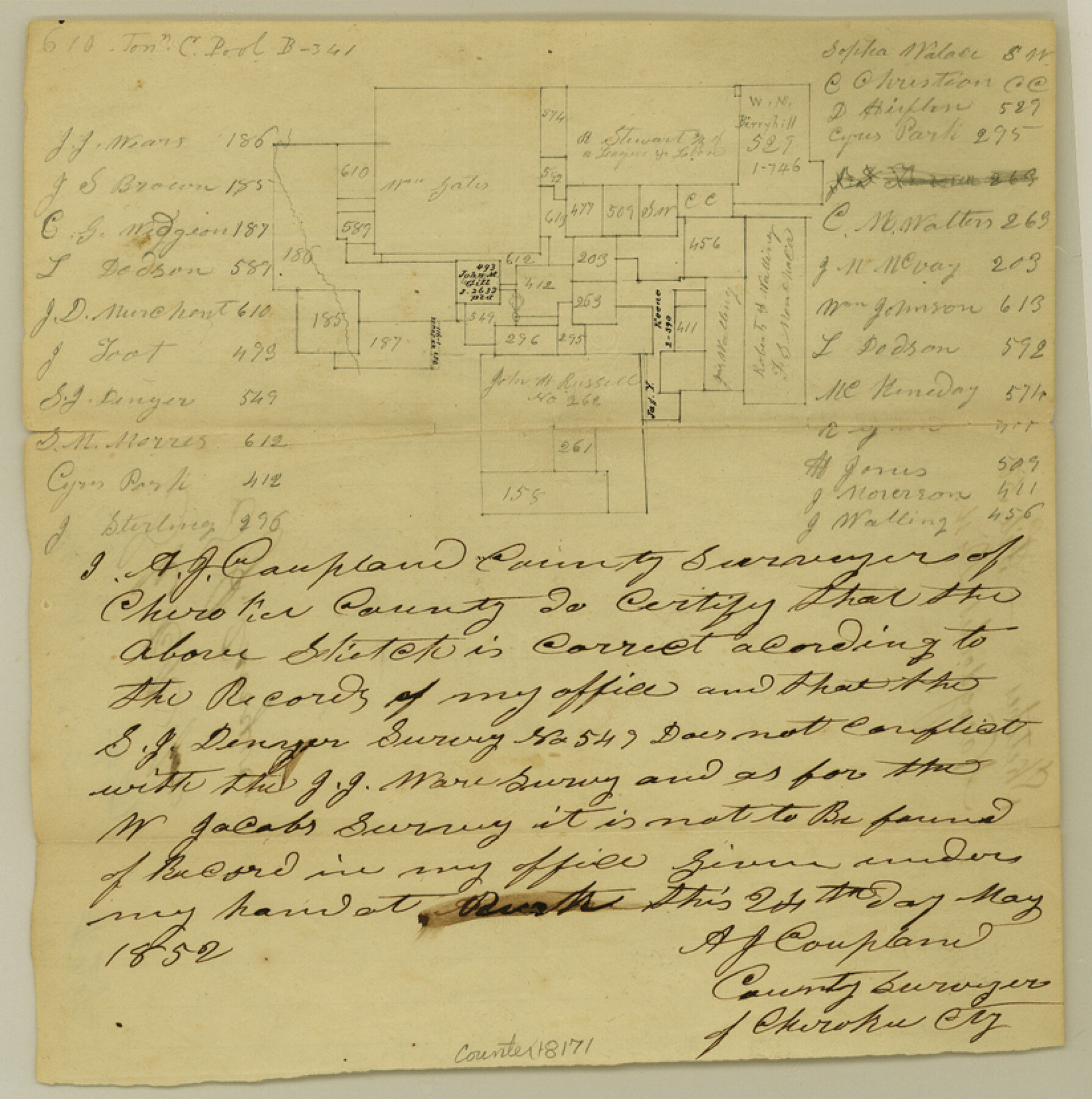
Cherokee County Sketch File 27
[Sketch of area around the John M. Russell survey north of Rusk]
-
Map/Doc
18171
-
Collection
General Map Collection
-
Object Dates
1852/5/24 (Creation Date)
-
People and Organizations
A.J. Coupland (Surveyor/Engineer)
-
Counties
Cherokee
-
Subjects
Surveying Sketch File
-
Height x Width
8.3 x 8.2 inches
21.1 x 20.8 cm
-
Medium
paper, manuscript
Part of: General Map Collection
Val Verde County Working Sketch 85

Print $20.00
- Digital $50.00
Val Verde County Working Sketch 85
1973
Size 28.5 x 38.3 inches
Map/Doc 72220
Sutton County Sketch File C

Print $6.00
- Digital $50.00
Sutton County Sketch File C
1900
Size 14.0 x 8.6 inches
Map/Doc 37379
Hunt County Rolled Sketch 5

Print $20.00
- Digital $50.00
Hunt County Rolled Sketch 5
1956
Size 27.5 x 24.3 inches
Map/Doc 6269
Galveston County NRC Article 33.136 Sketch 23

Print $22.00
- Digital $50.00
Galveston County NRC Article 33.136 Sketch 23
2002
Size 11.4 x 16.4 inches
Map/Doc 81905
Leon County Rolled Sketch 26A

Print $20.00
- Digital $50.00
Leon County Rolled Sketch 26A
1988
Size 21.5 x 34.4 inches
Map/Doc 6611
Nueces County Rolled Sketch 92

Print $222.00
Nueces County Rolled Sketch 92
1983
Size 24.6 x 43.7 inches
Map/Doc 7028
Intracoastal Waterway - Galveston Bay to West Bay including Galveston Bay Entrance

Print $20.00
- Digital $50.00
Intracoastal Waterway - Galveston Bay to West Bay including Galveston Bay Entrance
1957
Size 27.2 x 38.6 inches
Map/Doc 69932
Chambers County Working Sketch 10

Print $20.00
- Digital $50.00
Chambers County Working Sketch 10
1950
Size 40.1 x 33.0 inches
Map/Doc 67993
Fractional Township No. 8 South Range No. 1 East of the Indian Meridian, Indian Territory

Print $20.00
- Digital $50.00
Fractional Township No. 8 South Range No. 1 East of the Indian Meridian, Indian Territory
1898
Size 19.3 x 24.3 inches
Map/Doc 75200
Falls County Sketch File 6

Print $4.00
- Digital $50.00
Falls County Sketch File 6
1848
Size 12.8 x 8.3 inches
Map/Doc 22341
Colorado County Working Sketch 28

Print $20.00
- Digital $50.00
Colorado County Working Sketch 28
1979
Size 33.5 x 24.3 inches
Map/Doc 68128
Lamb County Rolled Sketch 2

Print $20.00
- Digital $50.00
Lamb County Rolled Sketch 2
1917
Size 37.9 x 43.4 inches
Map/Doc 9412
You may also like
Castro County Sketch File 4

Print $6.00
- Digital $50.00
Castro County Sketch File 4
1908
Size 6.9 x 8.9 inches
Map/Doc 17462
Haskell County Rolled Sketch 2

Print $20.00
- Digital $50.00
Haskell County Rolled Sketch 2
1902
Size 34.5 x 27.1 inches
Map/Doc 6163

Ector County Working Sketch 23

Print $40.00
- Digital $50.00
Ector County Working Sketch 23
1961
Size 55.9 x 43.3 inches
Map/Doc 68866
Willacy County Aerial Photograph Index Sheet 1

Print $20.00
- Digital $50.00
Willacy County Aerial Photograph Index Sheet 1
1940
Size 24.3 x 20.2 inches
Map/Doc 83756
Map of Clay Co.

Print $40.00
- Digital $50.00
Map of Clay Co.
1896
Size 51.9 x 31.0 inches
Map/Doc 4785
Mexico, Mittel-America, Texas

Print $20.00
- Digital $50.00
Mexico, Mittel-America, Texas
1850
Size 14.4 x 17.7 inches
Map/Doc 93710
Medina County

Print $40.00
- Digital $50.00
Medina County
1915
Size 50.0 x 42.0 inches
Map/Doc 66925
Smith County Rolled Sketch 6C

Print $20.00
- Digital $50.00
Smith County Rolled Sketch 6C
1943
Size 25.7 x 34.4 inches
Map/Doc 10701
[E. T. Ry. Blk. 1]
![89795, [E. T. Ry. Blk. 1], Twichell Survey Records](https://historictexasmaps.com/wmedia_w700/maps/89795-1.tif.jpg)
Print $40.00
- Digital $50.00
[E. T. Ry. Blk. 1]
Size 40.6 x 51.2 inches
Map/Doc 89795
Blanco County Working Sketch 7

Print $20.00
- Digital $50.00
Blanco County Working Sketch 7
1924
Size 12.9 x 12.1 inches
Map/Doc 67367
Map of Wilbarger County Young Land District formerly Fannin Land District

Print $20.00
- Digital $50.00
Map of Wilbarger County Young Land District formerly Fannin Land District
1859
Size 22.7 x 20.6 inches
Map/Doc 4146