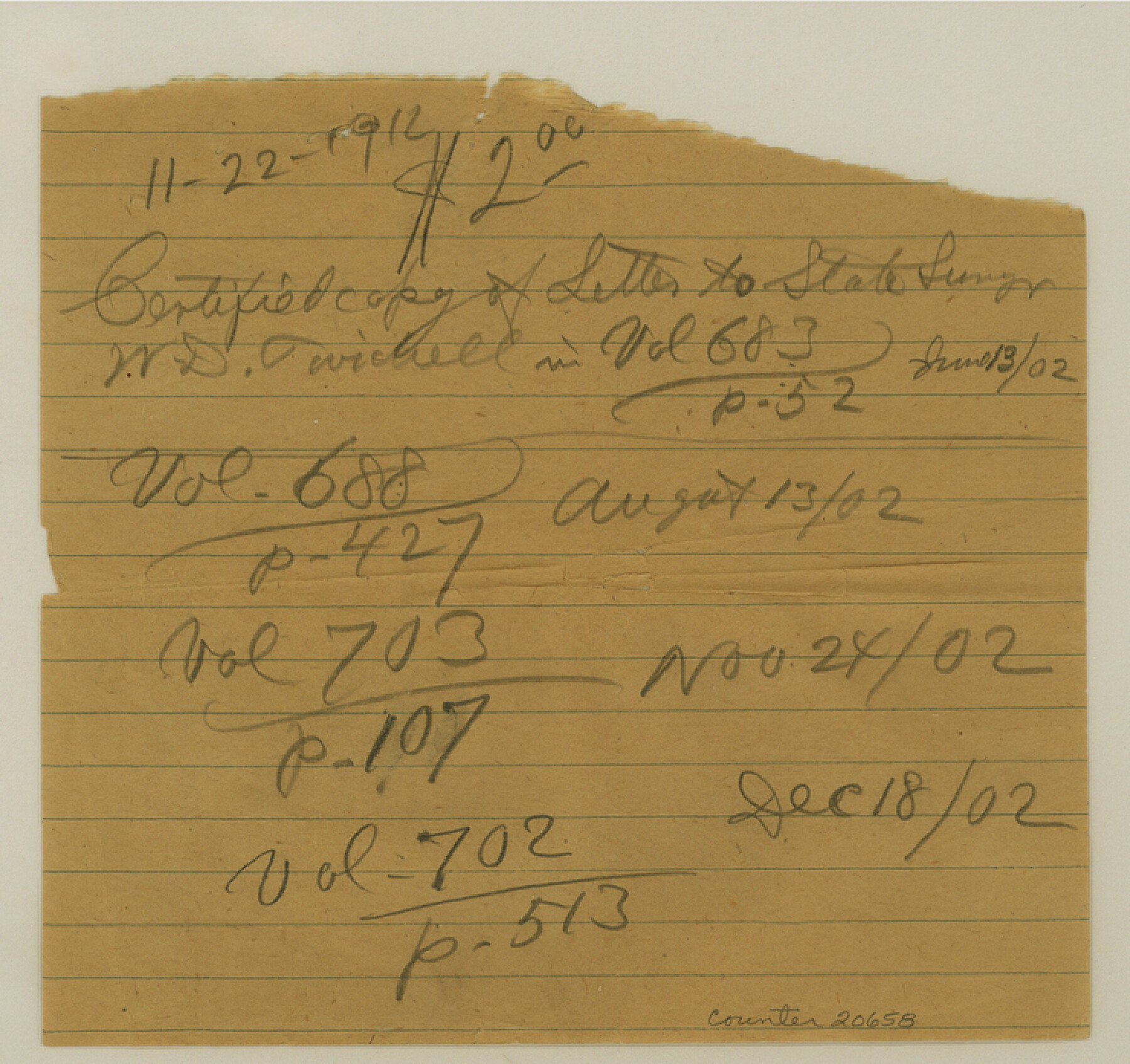
Deaf Smith County Sketch File 6
[Instructions and correspondence to H. G. Hays]
-
Map/Doc
20658
-
Collection
General Map Collection
-
Object Dates
1912/11/16 (Creation Date)
1912/11/18 (File Date)
1903/1/22 (Survey Date)
-
People and Organizations
E. von Rosenberg (Draftsman)
W.D. Twichell (Surveyor/Engineer)
Harvey G. Hayes (Surveyor/Engineer)
W.S. Mabry (Surveyor/Engineer)
-
Counties
Deaf Smith Oldham
-
Subjects
Surveying Sketch File
-
Height x Width
7.0 x 7.4 inches
17.8 x 18.8 cm
-
Medium
paper, manuscript
Part of: General Map Collection
Gaines County Working Sketch 3

Print $20.00
- Digital $50.00
Gaines County Working Sketch 3
1939
Size 45.6 x 43.8 inches
Map/Doc 69303
Cottle County Rolled Sketch 11

Print $20.00
- Digital $50.00
Cottle County Rolled Sketch 11
1927
Size 31.6 x 24.1 inches
Map/Doc 5568
Harris County Rolled Sketch 99

Print $20.00
- Digital $50.00
Harris County Rolled Sketch 99
1985
Size 16.2 x 20.2 inches
Map/Doc 6137
Maverick County Sketch File 26

Print $14.00
- Digital $50.00
Maverick County Sketch File 26
1955
Size 11.3 x 8.7 inches
Map/Doc 31153
Map of Texas Gulf Coast and Continental Shelf showing Natural Gas Pipe Lines

Print $40.00
- Digital $50.00
Map of Texas Gulf Coast and Continental Shelf showing Natural Gas Pipe Lines
1979
Size 40.9 x 59.3 inches
Map/Doc 75905
Aransas County Rolled Sketch 27E

Print $20.00
- Digital $50.00
Aransas County Rolled Sketch 27E
1958
Size 30.2 x 30.9 inches
Map/Doc 8419
Orange County Rolled Sketch RG

Print $40.00
- Digital $50.00
Orange County Rolled Sketch RG
1919
Size 32.7 x 61.2 inches
Map/Doc 9654
Culberson County Working Sketch 66

Print $40.00
- Digital $50.00
Culberson County Working Sketch 66
1975
Size 52.1 x 33.2 inches
Map/Doc 68520
Reeves County Working Sketch 21

Print $20.00
- Digital $50.00
Reeves County Working Sketch 21
1964
Size 32.7 x 27.0 inches
Map/Doc 63464
Victoria County Rolled Sketch 4C

Print $40.00
- Digital $50.00
Victoria County Rolled Sketch 4C
1963
Size 65.0 x 43.3 inches
Map/Doc 10097
Stonewall County Sketch File 12 and 12a

Print $30.00
- Digital $50.00
Stonewall County Sketch File 12 and 12a
1900
Size 9.2 x 9.0 inches
Map/Doc 37240
Caldwell County Working Sketch 13

Print $20.00
- Digital $50.00
Caldwell County Working Sketch 13
1987
Size 40.3 x 34.3 inches
Map/Doc 67843
You may also like
Roberts County Working Sketch 30

Print $20.00
- Digital $50.00
Roberts County Working Sketch 30
1983
Size 47.4 x 38.5 inches
Map/Doc 63556
Flight Mission No. DQO-2K, Frame 136, Galveston County

Print $20.00
- Digital $50.00
Flight Mission No. DQO-2K, Frame 136, Galveston County
1952
Size 18.8 x 22.6 inches
Map/Doc 85033
Jefferson County Working Sketch 25

Print $20.00
- Digital $50.00
Jefferson County Working Sketch 25
1977
Size 39.8 x 43.4 inches
Map/Doc 66568
Flight Mission No. CUG-1P, Frame 84, Kleberg County

Print $20.00
- Digital $50.00
Flight Mission No. CUG-1P, Frame 84, Kleberg County
1956
Size 18.4 x 22.3 inches
Map/Doc 86149

Kerr County Working Sketch 9

Print $20.00
- Digital $50.00
Kerr County Working Sketch 9
1949
Size 31.6 x 33.0 inches
Map/Doc 70040
Dimmit County Working Sketch 52

Print $20.00
- Digital $50.00
Dimmit County Working Sketch 52
1989
Size 25.2 x 37.0 inches
Map/Doc 68713
Gray's New Map of Texas and the Indian Territory

Print $20.00
- Digital $50.00
Gray's New Map of Texas and the Indian Territory
1876
Size 17.4 x 27.7 inches
Map/Doc 93786
Flight Mission No. CGI-3N, Frame 162, Cameron County

Print $20.00
- Digital $50.00
Flight Mission No. CGI-3N, Frame 162, Cameron County
1954
Size 18.6 x 22.3 inches
Map/Doc 84626
Leon County Working Sketch 59

Print $20.00
- Digital $50.00
Leon County Working Sketch 59
1998
Size 19.2 x 25.5 inches
Map/Doc 70459
Gillespie County Working Sketch 6

Print $20.00
- Digital $50.00
Gillespie County Working Sketch 6
1981
Size 22.5 x 21.6 inches
Map/Doc 63169
Wichita County Sketch File 25

Print $20.00
- Digital $50.00
Wichita County Sketch File 25
1919
Size 17.6 x 22.3 inches
Map/Doc 12685