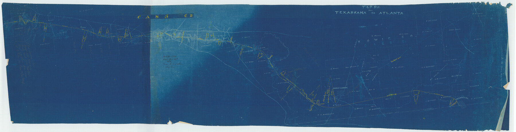
T&P Ry. from Texarkana to Atlanta
Z-2-51, K.7.77
-
Map/Doc
2327
-
Collection
General Map Collection
-
Object Dates
1910 (Creation Date)
1910/4/28 (File Date)
-
People and Organizations
B.S. Wathen (Surveyor/Engineer)
-
Counties
Bowie Cass
-
Subjects
Railroads Texas and Pacific Railroad
-
Height x Width
19.8 x 77.4 inches
50.3 x 196.6 cm
-
Comments
Also shows an abandoned rail line.
-
Features
Days Creek
Road to Boston
Bays Creek Road
Kirbys Ferry Road
Black Bayou
Winborn
Bakers Creek
Rodgers
Sulphur River
Hurricane Creek
T&P
Wards Creek
Alamo
Forest
Springdale
Lanark
Atlanta
Queen City
Moores Landing
Texarcana
Part of: General Map Collection
Marion County Rolled Sketch 1A

Print $15.00
- Digital $50.00
Marion County Rolled Sketch 1A
1954
Size 9.9 x 15.2 inches
Map/Doc 46610
Crockett County Rolled Sketch 50

Print $20.00
- Digital $50.00
Crockett County Rolled Sketch 50
1940
Size 31.5 x 40.7 inches
Map/Doc 8714
Haskell County Sketch File 7

Print $22.00
- Digital $50.00
Haskell County Sketch File 7
Size 7.8 x 13.4 inches
Map/Doc 26128
Flight Mission No. BRA-6M, Frame 76, Jefferson County

Print $20.00
- Digital $50.00
Flight Mission No. BRA-6M, Frame 76, Jefferson County
1953
Size 18.6 x 22.4 inches
Map/Doc 85420
Flight Mission No. DCL-5C, Frame 66, Kenedy County

Print $20.00
- Digital $50.00
Flight Mission No. DCL-5C, Frame 66, Kenedy County
1943
Size 18.4 x 22.3 inches
Map/Doc 85849
Baylor County Sketch File 19

Print $4.00
- Digital $50.00
Baylor County Sketch File 19
1885
Size 11.5 x 8.8 inches
Map/Doc 14193
Medina County Working Sketch 23

Print $20.00
- Digital $50.00
Medina County Working Sketch 23
Size 43.8 x 43.1 inches
Map/Doc 70938
Robertson County Working Sketch 9

Print $20.00
- Digital $50.00
Robertson County Working Sketch 9
1984
Size 19.9 x 21.5 inches
Map/Doc 63582
Wheeler County Sketch File 9

Print $12.00
- Digital $50.00
Wheeler County Sketch File 9
1989
Size 11.8 x 9.1 inches
Map/Doc 40008
Jack County Sketch File 24

Print $4.00
- Digital $50.00
Jack County Sketch File 24
1880
Size 8.3 x 9.5 inches
Map/Doc 27561
Hardin County Working Sketch 44

Print $40.00
- Digital $50.00
Hardin County Working Sketch 44
1954
Size 53.2 x 39.9 inches
Map/Doc 65610
Right of Way and Track Map of The Missouri, Kansas & Texas Railway of Texas

Print $40.00
- Digital $50.00
Right of Way and Track Map of The Missouri, Kansas & Texas Railway of Texas
1918
Size 25.2 x 106.9 inches
Map/Doc 64531
You may also like
Tom Green County Sketch File 63

Print $20.00
- Digital $50.00
Tom Green County Sketch File 63
1890
Size 31.8 x 17.9 inches
Map/Doc 12445
Upper Galveston Bay, Houston Ship Channel, Dollar Pt. to Atkinson I.

Print $40.00
- Digital $50.00
Upper Galveston Bay, Houston Ship Channel, Dollar Pt. to Atkinson I.
1978
Size 49.3 x 36.8 inches
Map/Doc 69898
[Lynn County School Land Leagues 292, 293, PSL Block C-30, and D. W. RR. Co. Block H]
![90797, [Lynn County School Land Leagues 292, 293, PSL Block C-30, and D. W. RR. Co. Block H], Twichell Survey Records](https://historictexasmaps.com/wmedia_w700/maps/90797-1.tif.jpg)
Print $20.00
- Digital $50.00
[Lynn County School Land Leagues 292, 293, PSL Block C-30, and D. W. RR. Co. Block H]
Size 21.3 x 20.6 inches
Map/Doc 90797

McMullen County Working Sketch 34

Print $20.00
- Digital $50.00
McMullen County Working Sketch 34
1959
Size 25.9 x 26.0 inches
Map/Doc 70735
Orange County Boundary File 1

Print $4.00
- Digital $50.00
Orange County Boundary File 1
Size 9.7 x 6.3 inches
Map/Doc 57773
Flight Mission No. BRE-1P, Frame 72, Nueces County

Print $20.00
- Digital $50.00
Flight Mission No. BRE-1P, Frame 72, Nueces County
1956
Size 18.4 x 22.3 inches
Map/Doc 86654
San Saba County Working Sketch 9

Print $20.00
- Digital $50.00
San Saba County Working Sketch 9
1983
Size 33.8 x 42.8 inches
Map/Doc 63797
Edwards County Sketch File 21

Print $6.00
- Digital $50.00
Edwards County Sketch File 21
1889
Size 12.9 x 8.5 inches
Map/Doc 21740
Controlled Mosaic by Jack Amman Photogrammetric Engineers, Inc - Sheet 9

Print $20.00
- Digital $50.00
Controlled Mosaic by Jack Amman Photogrammetric Engineers, Inc - Sheet 9
1954
Size 20.0 x 24.0 inches
Map/Doc 83453
Flight Mission No. BRE-2P, Frame 9, Nueces County

Print $20.00
- Digital $50.00
Flight Mission No. BRE-2P, Frame 9, Nueces County
1956
Size 18.5 x 22.3 inches
Map/Doc 86718
Upton County Sketch File 11

Print $20.00
- Digital $50.00
Upton County Sketch File 11
1919
Size 22.5 x 27.6 inches
Map/Doc 12511