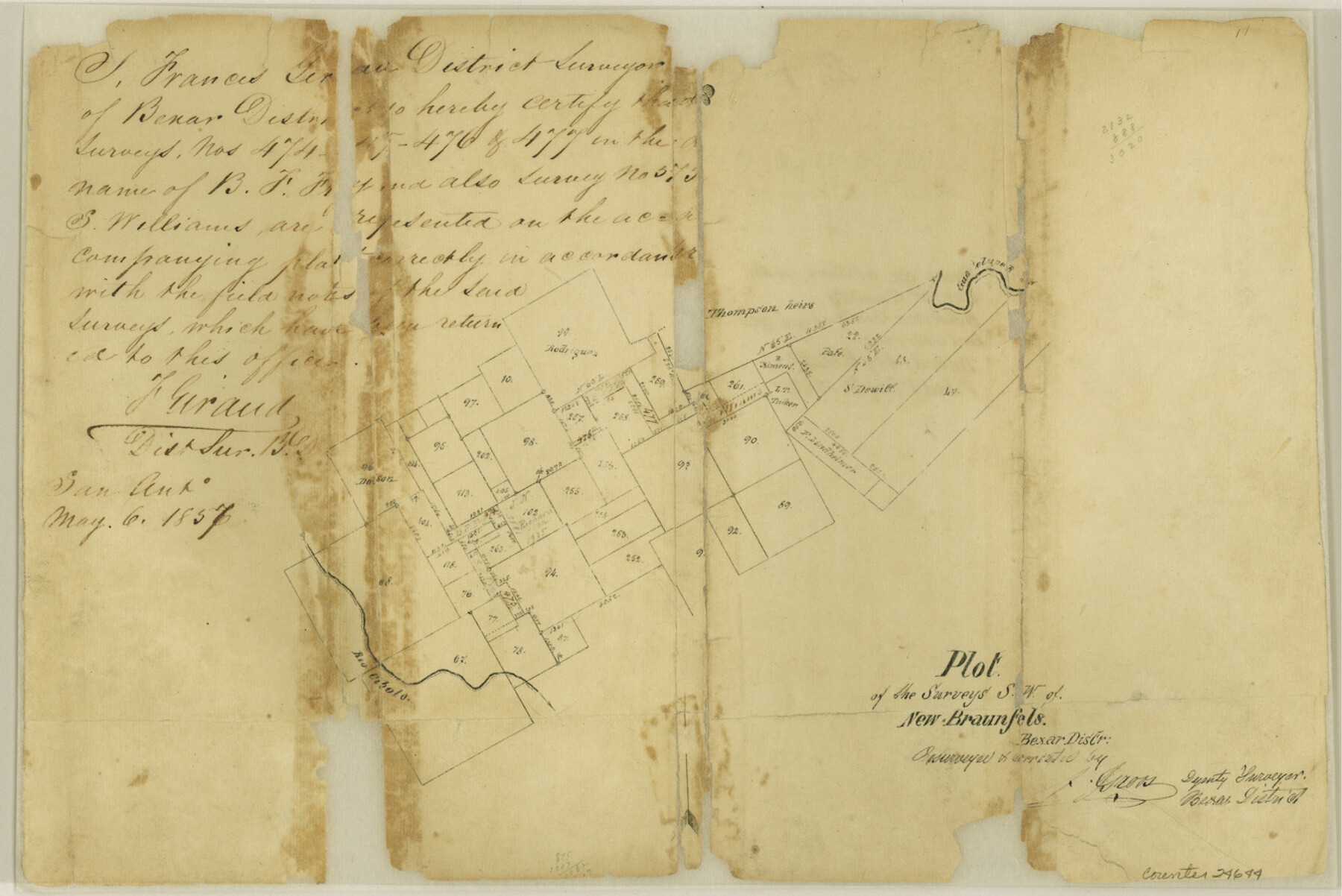
Guadalupe County Sketch File 1
[Sketch of surveys in northwest corner of the county between Guadalupe and Cibolo Rivers]
-
Map/Doc
24644
-
Collection
General Map Collection
-
Object Dates
1857/5/6 (Creation Date)
1857/5/30 (File Date)
-
People and Organizations
J. Groos (Surveyor/Engineer)
-
Counties
Guadalupe Bexar Comal
-
Subjects
Surveying Sketch File
-
Height x Width
8.9 x 13.4 inches
22.6 x 34.0 cm
-
Medium
paper, manuscript
-
Features
Guadalupe River
Rio Cibolo
Part of: General Map Collection
San Augustine County Sketch File 19

Print $23.00
San Augustine County Sketch File 19
Size 14.8 x 14.2 inches
Map/Doc 35678
Anderson County Sketch File 11

Print $6.00
- Digital $50.00
Anderson County Sketch File 11
1853
Size 8.7 x 6.6 inches
Map/Doc 12765
Cochran County Boundary File 2

Print $59.00
- Digital $50.00
Cochran County Boundary File 2
Size 14.8 x 9.3 inches
Map/Doc 51466
The south west and N.E. lines of Mary Thomas and A. Morrallis surveys

Print $2.00
- Digital $50.00
The south west and N.E. lines of Mary Thomas and A. Morrallis surveys
1847
Size 9.4 x 8.1 inches
Map/Doc 336
Presidio County Working Sketch 94

Print $20.00
- Digital $50.00
Presidio County Working Sketch 94
1976
Size 40.6 x 32.1 inches
Map/Doc 71771
Jefferson County Aerial Photograph Index Sheet 5

Print $20.00
- Digital $50.00
Jefferson County Aerial Photograph Index Sheet 5
1953
Size 23.3 x 16.9 inches
Map/Doc 83709
Burnet County Rolled Sketch 8

Print $40.00
- Digital $50.00
Burnet County Rolled Sketch 8
1971
Size 36.9 x 49.9 inches
Map/Doc 8554
Gulf of Mexico

Print $20.00
- Digital $50.00
Gulf of Mexico
1905
Size 18.3 x 26.8 inches
Map/Doc 72652
Menard County Working Sketch 4

Print $20.00
- Digital $50.00
Menard County Working Sketch 4
1914
Size 19.8 x 16.2 inches
Map/Doc 70951
Flight Mission No. CRE-2R, Frame 88, Jackson County

Print $20.00
- Digital $50.00
Flight Mission No. CRE-2R, Frame 88, Jackson County
1956
Size 15.9 x 15.9 inches
Map/Doc 85360
Borden County Working Sketch 13

Print $20.00
- Digital $50.00
Borden County Working Sketch 13
1958
Size 24.1 x 35.6 inches
Map/Doc 67473
Wood County Boundary File 1

Print $4.00
- Digital $50.00
Wood County Boundary File 1
Size 12.6 x 8.1 inches
Map/Doc 60154
You may also like
Throckmorton County Sketch File 7

Print $8.00
- Digital $50.00
Throckmorton County Sketch File 7
Size 14.3 x 8.8 inches
Map/Doc 38090
Flight Mission No. BRA-7M, Frame 13, Jefferson County

Print $20.00
- Digital $50.00
Flight Mission No. BRA-7M, Frame 13, Jefferson County
1953
Size 18.6 x 22.4 inches
Map/Doc 85464
[Oil and Gas Fields in West Texas]
![89884, [Oil and Gas Fields in West Texas], Twichell Survey Records](https://historictexasmaps.com/wmedia_w700/maps/89884-1.tif.jpg)
Print $40.00
- Digital $50.00
[Oil and Gas Fields in West Texas]
Size 38.5 x 59.2 inches
Map/Doc 89884
[Township 5-S, Blocks 37 & 38]
![92801, [Township 5-S, Blocks 37 & 38], Twichell Survey Records](https://historictexasmaps.com/wmedia_w700/maps/92801-1.tif.jpg)
Print $20.00
- Digital $50.00
[Township 5-S, Blocks 37 & 38]
Size 23.3 x 17.5 inches
Map/Doc 92801
General Highway Map. Detail of Cities and Towns in Travis County, Texas

Print $20.00
General Highway Map. Detail of Cities and Towns in Travis County, Texas
1961
Size 18.2 x 24.9 inches
Map/Doc 79681
Burleson County Working Sketch 32

Print $20.00
- Digital $50.00
Burleson County Working Sketch 32
1981
Size 26.3 x 13.5 inches
Map/Doc 67751
Newton County Working Sketch 45

Print $20.00
- Digital $50.00
Newton County Working Sketch 45
1996
Size 16.4 x 24.0 inches
Map/Doc 71291
Calhoun County Rolled Sketch 11

Print $20.00
- Digital $50.00
Calhoun County Rolled Sketch 11
1942
Size 10.6 x 40.7 inches
Map/Doc 5367
Castro County Sketch File 3a

Print $4.00
- Digital $50.00
Castro County Sketch File 3a
1888
Size 14.1 x 8.4 inches
Map/Doc 17460
Flight Mission No. DCL-6C, Frame 129, Kenedy County

Print $20.00
- Digital $50.00
Flight Mission No. DCL-6C, Frame 129, Kenedy County
1943
Size 18.5 x 22.3 inches
Map/Doc 85959
Cochran County

Print $20.00
- Digital $50.00
Cochran County
1899
Size 40.9 x 32.6 inches
Map/Doc 4744
El Paso County Working Sketch 59

Print $20.00
- Digital $50.00
El Paso County Working Sketch 59
2000
Size 28.1 x 35.7 inches
Map/Doc 69081