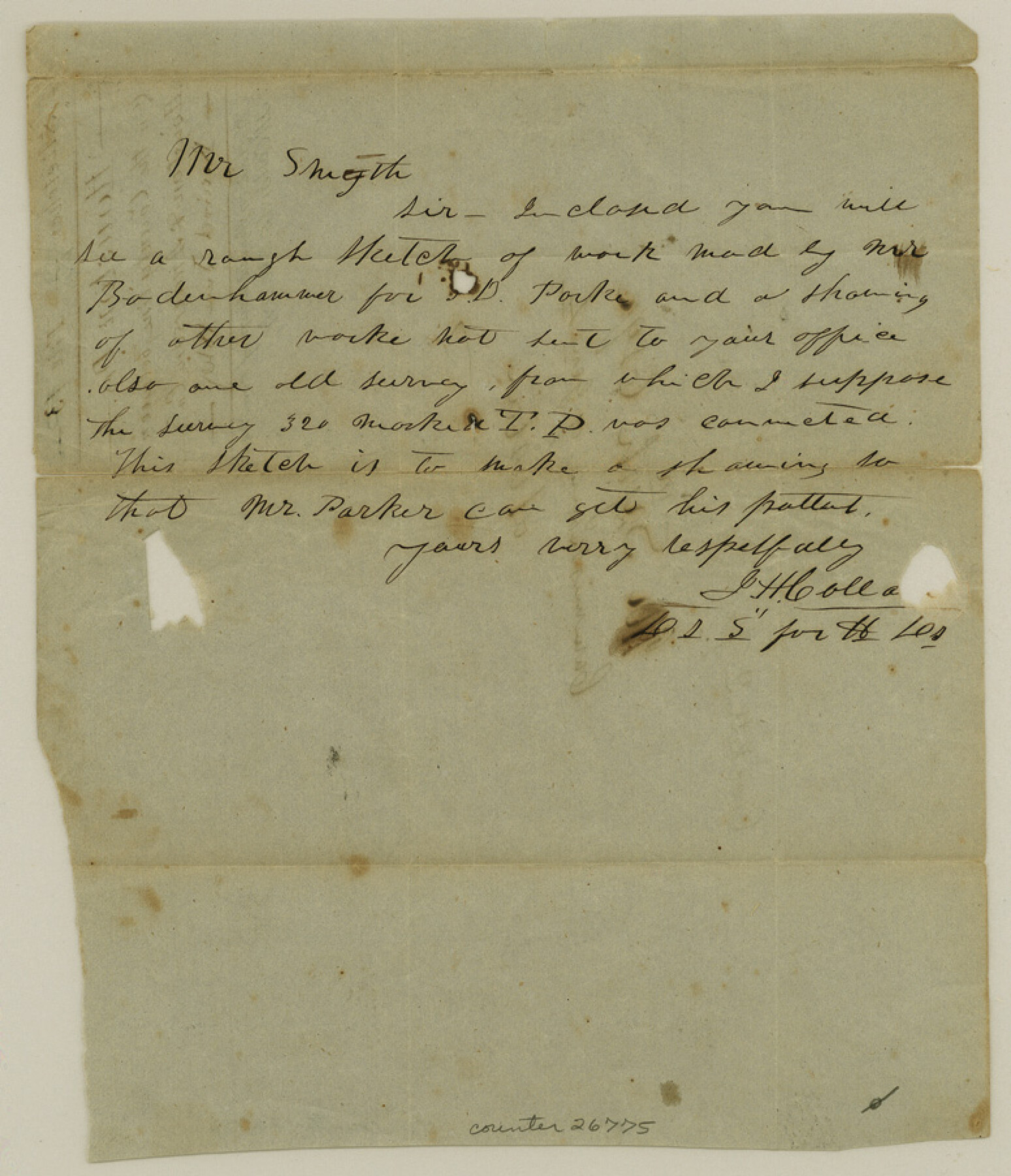
Houston County Sketch File 13
[Sketch on county line between Houston and Anderson Counties]
-
Map/Doc
26775
-
Collection
General Map Collection
-
People and Organizations
J.H. Collard (Surveyor/Engineer)
Bodenhammer (Draftsman)
-
Counties
Houston Anderson
-
Subjects
Surveying Sketch File
-
Height x Width
9.0 x 7.8 inches
22.9 x 19.8 cm
-
Medium
paper, manuscript
Part of: General Map Collection
McMullen County Rolled Sketch 7

Print $40.00
- Digital $50.00
McMullen County Rolled Sketch 7
1939
Size 38.8 x 51.7 inches
Map/Doc 9500
Wilbarger County Sketch File 1

Print $4.00
- Digital $50.00
Wilbarger County Sketch File 1
Size 8.2 x 12.8 inches
Map/Doc 40162
Bexar County Working Sketch 6

Print $40.00
- Digital $50.00
Bexar County Working Sketch 6
1945
Size 56.4 x 41.2 inches
Map/Doc 67322
Franklin County Working Sketch 4

Print $20.00
- Digital $50.00
Franklin County Working Sketch 4
1999
Size 19.2 x 16.6 inches
Map/Doc 69242
Map of Brazoria

Print $20.00
- Digital $50.00
Map of Brazoria
1860
Size 19.8 x 26.7 inches
Map/Doc 856
El Paso County Rolled Sketch 52

Print $20.00
- Digital $50.00
El Paso County Rolled Sketch 52
1932
Size 18.3 x 24.3 inches
Map/Doc 5843
Walker County Working Sketch 3

Print $20.00
- Digital $50.00
Walker County Working Sketch 3
1931
Size 26.4 x 18.2 inches
Map/Doc 72283
Flight Mission No. CLL-1N, Frame 10, Willacy County

Print $20.00
- Digital $50.00
Flight Mission No. CLL-1N, Frame 10, Willacy County
1954
Size 18.5 x 22.1 inches
Map/Doc 86997
Hutchinson County Working Sketch 15

Print $20.00
- Digital $50.00
Hutchinson County Working Sketch 15
1949
Size 26.4 x 15.4 inches
Map/Doc 66373
Howard County Working Sketch 11

Print $20.00
- Digital $50.00
Howard County Working Sketch 11
1962
Size 20.5 x 20.3 inches
Map/Doc 66279
Haskell County Working Sketch 7

Print $40.00
- Digital $50.00
Haskell County Working Sketch 7
1956
Size 52.1 x 39.0 inches
Map/Doc 66065
Cass County Sketch File 7

Print $4.00
- Digital $50.00
Cass County Sketch File 7
1853
Size 8.0 x 12.6 inches
Map/Doc 17408
You may also like
Flight Mission No. DQN-2K, Frame 33, Calhoun County

Print $20.00
- Digital $50.00
Flight Mission No. DQN-2K, Frame 33, Calhoun County
1953
Size 18.6 x 22.2 inches
Map/Doc 84240
Map of that Portion of the Boundary Between the United States and Mexico from the Pacific Coast to the Junction of the Gila and Colorado Rivers

Print $40.00
Map of that Portion of the Boundary Between the United States and Mexico from the Pacific Coast to the Junction of the Gila and Colorado Rivers
1854
Size 23.9 x 51.4 inches
Map/Doc 79323
Calhoun County Rolled Sketch 34

Print $181.00
- Digital $50.00
Calhoun County Rolled Sketch 34
1977
Size 10.0 x 16.2 inches
Map/Doc 43714
Starr County Rolled Sketch 30

Print $20.00
- Digital $50.00
Starr County Rolled Sketch 30
1941
Size 14.9 x 21.5 inches
Map/Doc 7813
![90607, [Block K8], Twichell Survey Records](https://historictexasmaps.com/wmedia_w700/maps/90607-1.tif.jpg)
University Land, Lamar County

Print $20.00
- Digital $50.00
University Land, Lamar County
1906
Size 23.8 x 29.9 inches
Map/Doc 2431
Duval County Rolled Sketch 51

Print $20.00
- Digital $50.00
Duval County Rolled Sketch 51
Size 19.1 x 16.9 inches
Map/Doc 5765
Limestone County Working Sketch 27

Print $20.00
- Digital $50.00
Limestone County Working Sketch 27
2008
Size 34.4 x 35.6 inches
Map/Doc 88767
Tom Green County Sketch File 75

Print $20.00
- Digital $50.00
Tom Green County Sketch File 75
1950
Size 18.1 x 22.5 inches
Map/Doc 12449
Denton County Boundary File 1a

Print $24.00
- Digital $50.00
Denton County Boundary File 1a
Size 12.4 x 8.1 inches
Map/Doc 52401
Map of Panama, Texas

Print $5.00
- Digital $50.00
Map of Panama, Texas
1908
Size 10.4 x 15.6 inches
Map/Doc 94104
[Surveys along the San Marcos River]
![152, [Surveys along the San Marcos River], General Map Collection](https://historictexasmaps.com/wmedia_w700/maps/152.tif.jpg)
Print $2.00
- Digital $50.00
[Surveys along the San Marcos River]
Size 9.6 x 8.0 inches
Map/Doc 152