Karnes County Sketch File 13
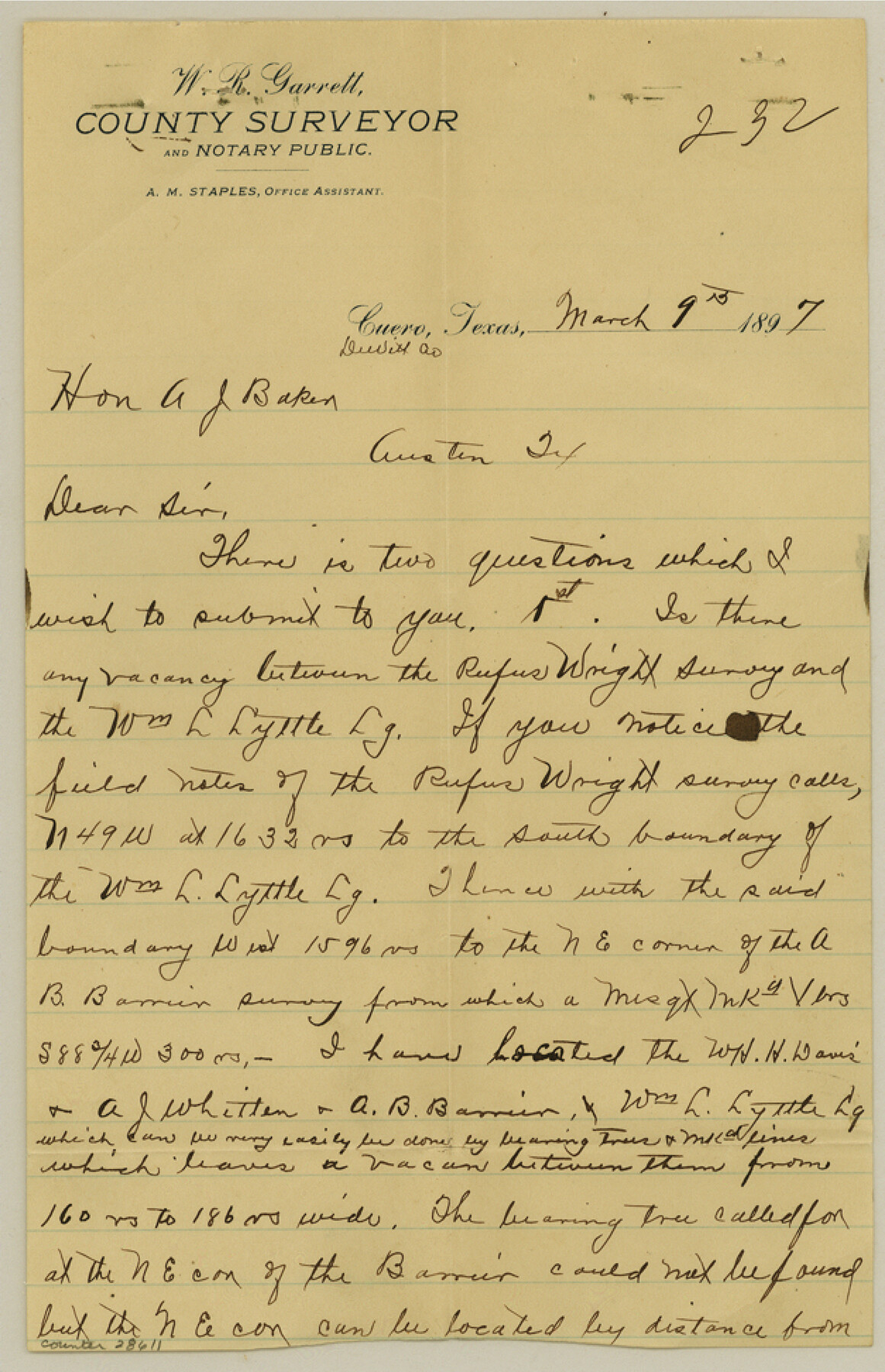
[Letter regarding vacancy between Rufus Wright and William L. Lyttle surveys in DeWitt County]
-
Map/Doc
28611
-
Collection
General Map Collection
-
Object Dates
3/9/1897 (Creation Date)
1858 (Survey Date)
1883 (Survey Date)
-
People and Organizations
W.R. Garrett (Surveyor/Engineer)
C.G. Hartman (Surveyor/Engineer)
-
Counties
DeWitt
-
Subjects
Surveying Sketch File
-
Height x Width
9.7 x 6.3 inches
24.6 x 16.0 cm
-
Medium
paper, manuscript
-
Features
Helena and Yorktown Road
Cabeza Creek
Part of: General Map Collection

Bandera County Working Sketch 17

Print $20.00
- Digital $50.00
Bandera County Working Sketch 17
1943
Size 21.2 x 27.5 inches
Map/Doc 67613
Flight Mission No. CRC-3R, Frame 46, Chambers County

Print $20.00
- Digital $50.00
Flight Mission No. CRC-3R, Frame 46, Chambers County
1956
Size 18.6 x 22.5 inches
Map/Doc 84819
Johnson County Sketch File 23

Print $22.00
- Digital $50.00
Johnson County Sketch File 23
1857
Size 8.1 x 12.6 inches
Map/Doc 28456
Haskell County Working Sketch Graphic Index

Print $20.00
- Digital $50.00
Haskell County Working Sketch Graphic Index
1933
Size 43.3 x 37.7 inches
Map/Doc 76572
Garza County Working Sketch 16

Print $20.00
- Digital $50.00
Garza County Working Sketch 16
1994
Size 21.7 x 40.3 inches
Map/Doc 63163
Mitchell County Rolled Sketch 2A

Print $20.00
- Digital $50.00
Mitchell County Rolled Sketch 2A
Size 24.2 x 18.5 inches
Map/Doc 88857
[Jack District]
![1992, [Jack District], General Map Collection](https://historictexasmaps.com/wmedia_w700/maps/1992.tif.jpg)
Print $40.00
- Digital $50.00
[Jack District]
1880
Size 52.7 x 43.4 inches
Map/Doc 1992
La Salle County Rolled Sketch 14

Print $20.00
- Digital $50.00
La Salle County Rolled Sketch 14
Size 22.3 x 24.8 inches
Map/Doc 6577
[Map of Tom Green County]
![82061, [Map of Tom Green County], General Map Collection](https://historictexasmaps.com/wmedia_w700/maps/82061.tif.jpg)
Print $40.00
- Digital $50.00
[Map of Tom Green County]
1933
Size 50.0 x 60.6 inches
Map/Doc 82061
Hudspeth County Rolled Sketch 36

Print $20.00
- Digital $50.00
Hudspeth County Rolled Sketch 36
1952
Size 30.8 x 19.9 inches
Map/Doc 6249
Tarrant County Sketch File 32

Print $16.00
- Digital $50.00
Tarrant County Sketch File 32
1946
Size 11.3 x 8.8 inches
Map/Doc 37751
You may also like
Cameron County Working Sketch 1

Print $20.00
- Digital $50.00
Cameron County Working Sketch 1
Size 42.8 x 30.1 inches
Map/Doc 67880
Orange County Sketch File B1

Print $22.00
- Digital $50.00
Orange County Sketch File B1
Size 14.3 x 8.9 inches
Map/Doc 33288
General Highway Map of Gaines County, Texas

Print $20.00
- Digital $50.00
General Highway Map of Gaines County, Texas
1951
Size 19.0 x 26.2 inches
Map/Doc 92644
Map Showing Parallel 35°12' North Latitude from the 42nd Mile Post on the 100th Meridian to the Southeast Corner of Texas

Print $20.00
- Digital $50.00
Map Showing Parallel 35°12' North Latitude from the 42nd Mile Post on the 100th Meridian to the Southeast Corner of Texas
1890
Size 24.7 x 27.7 inches
Map/Doc 89840
[Block M24, Surveys 1-8 and vicinity]
![91231, [Block M24, Surveys 1-8 and vicinity], Twichell Survey Records](https://historictexasmaps.com/wmedia_w700/maps/91231-1.tif.jpg)
Print $20.00
- Digital $50.00
[Block M24, Surveys 1-8 and vicinity]
1909
Size 16.4 x 18.2 inches
Map/Doc 91231
Hopkins County Sketch File 2

Print $28.00
- Digital $50.00
Hopkins County Sketch File 2
1845
Size 11.1 x 7.9 inches
Map/Doc 26678
Culberson County Sketch File 8

Print $40.00
- Digital $50.00
Culberson County Sketch File 8
1904
Size 13.2 x 14.6 inches
Map/Doc 20142
Pecos County Working Sketch 87

Print $20.00
- Digital $50.00
Pecos County Working Sketch 87
1962
Size 29.0 x 31.6 inches
Map/Doc 71559
Pecos County Working Sketch 10

Print $20.00
- Digital $50.00
Pecos County Working Sketch 10
1907
Size 25.9 x 23.9 inches
Map/Doc 71480
[Sketch of surveys around W.T. Brewer]
![89926, [Sketch of surveys around W.T. Brewer], Twichell Survey Records](https://historictexasmaps.com/wmedia_w700/maps/89926-1.tif.jpg)
Print $40.00
- Digital $50.00
[Sketch of surveys around W.T. Brewer]
Size 37.0 x 48.7 inches
Map/Doc 89926
Hutchinson County Working Sketch Graphic Index - sheet 1

Print $20.00
- Digital $50.00
Hutchinson County Working Sketch Graphic Index - sheet 1
1922
Size 44.1 x 36.8 inches
Map/Doc 76586
Controlled Mosaic by Jack Amman Photogrammetric Engineers, Inc - Sheet 18

Print $20.00
- Digital $50.00
Controlled Mosaic by Jack Amman Photogrammetric Engineers, Inc - Sheet 18
1954
Size 20.0 x 24.0 inches
Map/Doc 83462