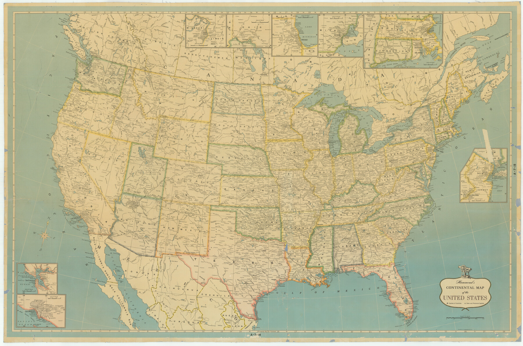
Hammond's Continental Map od the United States.
A-7-15
-
Map/Doc
3118
-
Collection
General Map Collection
-
Object Dates
1940 (Creation Date)
-
People and Organizations
C. S. Hammond and Company, New York (Publisher)
-
Subjects
United States
-
Height x Width
33.2 x 50.2 inches
84.3 x 127.5 cm
Part of: General Map Collection
Angelina County Sketch File 11b

Print $6.00
- Digital $50.00
Angelina County Sketch File 11b
1859
Size 17.7 x 8.3 inches
Map/Doc 12944
Dimmit County Working Sketch 18

Print $6.00
- Digital $50.00
Dimmit County Working Sketch 18
1946
Size 33.5 x 35.0 inches
Map/Doc 68679
Bee County Sketch File 30

Print $6.00
- Digital $50.00
Bee County Sketch File 30
Size 14.2 x 8.9 inches
Map/Doc 14341
Mason County Working Sketch 15

Print $40.00
- Digital $50.00
Mason County Working Sketch 15
Size 61.9 x 45.4 inches
Map/Doc 70851
Flight Mission No. CGI-4N, Frame 165, Cameron County

Print $20.00
- Digital $50.00
Flight Mission No. CGI-4N, Frame 165, Cameron County
1955
Size 18.4 x 22.3 inches
Map/Doc 84673
Plan de la Villa de Austin

Print $20.00
- Digital $50.00
Plan de la Villa de Austin
1828
Size 18.5 x 12.5 inches
Map/Doc 94116
Controlled Mosaic by Jack Amman Photogrammetric Engineers, Inc - Sheet 18

Print $20.00
- Digital $50.00
Controlled Mosaic by Jack Amman Photogrammetric Engineers, Inc - Sheet 18
1954
Size 19.4 x 24.0 inches
Map/Doc 83463
Colorado County Working Sketch 17

Print $20.00
- Digital $50.00
Colorado County Working Sketch 17
1952
Size 36.4 x 30.2 inches
Map/Doc 68117
Northeast Part of Crockett County

Print $20.00
- Digital $50.00
Northeast Part of Crockett County
1976
Size 35.6 x 46.1 inches
Map/Doc 73120
Sutton County Working Sketch 34

Print $20.00
- Digital $50.00
Sutton County Working Sketch 34
Size 24.3 x 30.6 inches
Map/Doc 62377
McMullen County Sketch File 43

Print $10.00
- Digital $50.00
McMullen County Sketch File 43
1942
Size 14.2 x 8.8 inches
Map/Doc 31421
Little River, Faubion Bridge Sheet

Print $4.00
- Digital $50.00
Little River, Faubion Bridge Sheet
1914
Size 19.0 x 27.8 inches
Map/Doc 65060
You may also like
Flight Mission No. BRA-8M, Frame 67, Jefferson County

Print $20.00
- Digital $50.00
Flight Mission No. BRA-8M, Frame 67, Jefferson County
1953
Size 18.8 x 22.5 inches
Map/Doc 85587
Flight Mission No. CUG-3P, Frame 91, Kleberg County

Print $20.00
- Digital $50.00
Flight Mission No. CUG-3P, Frame 91, Kleberg County
1956
Size 18.4 x 22.2 inches
Map/Doc 86261
Harbor Pass and Bar at Brazos Santiago, Texas

Print $20.00
- Digital $50.00
Harbor Pass and Bar at Brazos Santiago, Texas
1871
Size 18.3 x 26.8 inches
Map/Doc 72982
The Republic County of Jackson. January 19, 1841

Print $20.00
- Digital $50.00
The Republic County of Jackson. January 19, 1841
2020
Size 7.8 x 10.9 inches
Map/Doc 96188
Coleman County Sketch File 29

Print $40.00
- Digital $50.00
Coleman County Sketch File 29
1873
Size 16.9 x 12.9 inches
Map/Doc 18718
From Citizens Living in Gonzales and Victoria Counties for the Creation of a New Judicial County to be Called Guadalupe, Undated

Print $20.00
- Digital $50.00
From Citizens Living in Gonzales and Victoria Counties for the Creation of a New Judicial County to be Called Guadalupe, Undated
2020
Size 12.3 x 10.8 inches
Map/Doc 96413
Kinney County Working Sketch 27

Print $20.00
- Digital $50.00
Kinney County Working Sketch 27
1956
Size 23.1 x 25.1 inches
Map/Doc 70209
Morris County Working Sketch 3

Print $20.00
- Digital $50.00
Morris County Working Sketch 3
Size 27.6 x 38.2 inches
Map/Doc 71202
Glasscock County Sketch File 26

Print $20.00
- Digital $50.00
Glasscock County Sketch File 26
1951
Size 16.1 x 28.3 inches
Map/Doc 11567
Right of Way and Track Map of The Wichita Falls & Southern Railroad Company

Print $40.00
- Digital $50.00
Right of Way and Track Map of The Wichita Falls & Southern Railroad Company
1942
Size 24.7 x 56.3 inches
Map/Doc 64521
Flight Mission No. BQY-4M, Frame 54, Harris County

Print $20.00
- Digital $50.00
Flight Mission No. BQY-4M, Frame 54, Harris County
1953
Size 18.6 x 22.4 inches
Map/Doc 85263
Yoakum County Rolled Sketch 3(2)

Print $40.00
- Digital $50.00
Yoakum County Rolled Sketch 3(2)
1959
Size 12.3 x 120.8 inches
Map/Doc 76040