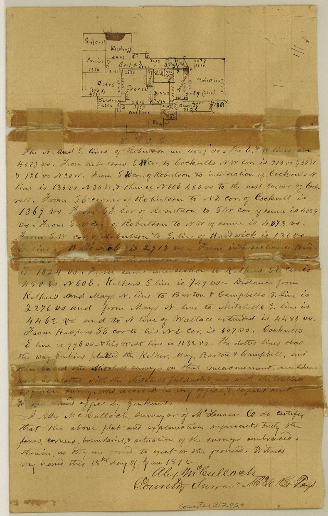
McLennan County Sketch File 14
[Explanation and sketch in regard to J.B. Robertson's survey west of Waco]
- 
                          Map/Doc31272
- 
                            CollectionGeneral Map Collection
- 
                            Object Dates1/18/1872 (Creation Date)1/23/1872 (File Date)
- 
                            People and OrganizationsAlex McCulloch (Surveyor/Engineer)
- 
                            CountiesMcLennan
- 
                            SubjectsSurveying Sketch File
- 
                            Height x Width12.4 x 7.9 inches31.5 x 20.1 cm
- 
                            Mediumpaper, manuscript
Part of: General Map Collection
            Asher and Adams' Texas - Western Portion


                                            Print $20.00                    
                                             -                         Digital $50.00                                    
                Asher and Adams' Texas - Western Portion
1874
Size 24.6 x 18.1 inches
                                Map/Doc 93787
            
            Flight Mission No. CON-2R, Frame 116, Stonewall County


                                            Print $20.00                    
                                             -                         Digital $50.00                                    
                Flight Mission No. CON-2R, Frame 116, Stonewall County
1957
Size 18.3 x 22.2 inches
                                Map/Doc 86990
            
            Flight Mission No. DAH-9M, Frame 83, Orange County


                                            Print $20.00                    
                                             -                         Digital $50.00                                    
                Flight Mission No. DAH-9M, Frame 83, Orange County
1953
Size 18.5 x 22.3 inches
                                Map/Doc 86847
            
            Reeves County Rolled Sketch P


                                            Print $20.00                    
                                             -                         Digital $50.00                                    
                Reeves County Rolled Sketch P
Size 33.2 x 29.2 inches
                                Map/Doc 9847
            
            Jefferson County Rolled Sketch 52


                                            Print $40.00                    
                                             -                         Digital $50.00                                    
                Jefferson County Rolled Sketch 52
Size 28.2 x 52.9 inches
                                Map/Doc 9308
            
            Matagorda Bay and Approaches


                                            Print $20.00                    
                                             -                         Digital $50.00                                    
                Matagorda Bay and Approaches
1972
Size 34.8 x 44.8 inches
                                Map/Doc 73384
            
            Potter County Boundary File 3b


                                            Print $12.00                    
                                             -                         Digital $50.00                                    
                Potter County Boundary File 3b
Size 9.8 x 6.4 inches
                                Map/Doc 57979
            
            Moore County Working Sketch 3


                                            Print $20.00                    
                                             -                         Digital $50.00                                    
                Moore County Working Sketch 3
1910
Size 12.2 x 17.4 inches
                                Map/Doc 71185
            
            Montague County Working Sketch 27


                                            Print $20.00                    
                                             -                         Digital $50.00                                    
                Montague County Working Sketch 27
1956
Size 35.8 x 24.9 inches
                                Map/Doc 71093
            
            Caddo Lake and Subdivision


                                            Print $20.00                    
                                             -                         Digital $50.00                                    
                Caddo Lake and Subdivision
1918
Size 35.0 x 29.8 inches
                                Map/Doc 93283
            
            Map of Taylor, Bastrop & Houston Railroad in Austin County


                                            Print $20.00                    
                                             -                         Digital $50.00                                    
                Map of Taylor, Bastrop & Houston Railroad in Austin County
Size 14.6 x 25.1 inches
                                Map/Doc 64480
            You may also like
            Jack County Sketch File 2


                                            Print $6.00                    
                                             -                         Digital $50.00                                    
                Jack County Sketch File 2
1856
Size 8.8 x 8.0 inches
                                Map/Doc 27501
            
            Coke County Sketch File 27


                                            Print $26.00                    
                                             -                         Digital $50.00                                    
                Coke County Sketch File 27
1937
Size 11.2 x 8.7 inches
                                Map/Doc 18638
            
            The Chief Justice County of Refugio. Proposed, No Date


                                            Print $20.00                    
                                    
                The Chief Justice County of Refugio. Proposed, No Date
2020
Size 22.6 x 21.7 inches
                                Map/Doc 96067
            
            [New York, Texas & Mexican Railway]
            
                                    ![64148, [New York, Texas & Mexican Railway], General Map Collection](https://historictexasmaps.com/wmedia_w700/maps/64148.tif.jpg) 


    ![64148, [New York, Texas & Mexican Railway], General Map Collection](https://historictexasmaps.com/wmedia_w700/maps/64148.tif.jpg) 
                                
            
                                            Print $20.00                    
                                             -                         Digital $50.00                                    
                [New York, Texas & Mexican Railway]
Size 12.1 x 24.1 inches
                                Map/Doc 64148
            
            Hidalgo County


                                            Print $20.00                    
                                             -                         Digital $50.00                                    
                Hidalgo County
1863
Size 46.0 x 25.2 inches
                                Map/Doc 3668
            
            Brewster County Sketch File 14


                                            Print $26.00                    
                                             -                         Digital $50.00                                    
                Brewster County Sketch File 14
Size 11.2 x 8.8 inches
                                Map/Doc 15746
            
            Correspondence between the Political Chief of Nacogdoches and the Ayuntamiento (CPCNA)


            Correspondence between the Political Chief of Nacogdoches and the Ayuntamiento (CPCNA)
Size 12.7 x 9.7 inches
                                Map/Doc 94263
            
            [Sketch showing T.&P. "B" Blocks in Tsp. 1S, Tsp. 2S, Tsp. 3S and Tsp. 4S]
            
                                    ![89747, [Sketch showing T.&P. "B" Blocks in Tsp. 1S, Tsp. 2S, Tsp. 3S and Tsp. 4S], Twichell Survey Records](https://historictexasmaps.com/wmedia_w700/maps/89747-1.tif.jpg) 


    ![89747, [Sketch showing T.&P. "B" Blocks in Tsp. 1S, Tsp. 2S, Tsp. 3S and Tsp. 4S], Twichell Survey Records](https://historictexasmaps.com/wmedia_w700/maps/89747-1.tif.jpg) 
                                
            
                                            Print $40.00                    
                                             -                         Digital $50.00                                    
                [Sketch showing T.&P. "B" Blocks in Tsp. 1S, Tsp. 2S, Tsp. 3S and Tsp. 4S]
Size 49.4 x 42.5 inches
                                Map/Doc 89747
            
            Leon County Sketch File 3


                                            Print $4.00                    
                                             -                         Digital $50.00                                    
                Leon County Sketch File 3
Size 12.4 x 7.9 inches
                                Map/Doc 29713
            
            [Ft. W. & R. G. Ry. Right of Way Map, Chapin to Bluffdale, Hood County, Texas]
            
                                    ![64646, [Ft. W. & R. G. Ry. Right of Way Map, Chapin to Bluffdale, Hood County, Texas], General Map Collection](https://historictexasmaps.com/wmedia_w700/maps/64646.tif.jpg) 


    ![64646, [Ft. W. & R. G. Ry. Right of Way Map, Chapin to Bluffdale, Hood County, Texas], General Map Collection](https://historictexasmaps.com/wmedia_w700/maps/64646.tif.jpg) 
                                
            
                                            Print $40.00                    
                                             -                         Digital $50.00                                    
                [Ft. W. & R. G. Ry. Right of Way Map, Chapin to Bluffdale, Hood County, Texas]
1918
Size 36.8 x 69.7 inches
                                Map/Doc 64646
            
            San Augustine County Sketch File 12


                                            Print $4.00                    
                                    
                San Augustine County Sketch File 12
Size 12.2 x 7.9 inches
                                Map/Doc 35656
            
            Cass County Working Sketch 39


                                            Print $20.00                    
                                             -                         Digital $50.00                                    
                Cass County Working Sketch 39
1983
Size 26.3 x 34.6 inches
                                Map/Doc 67942
             
                            