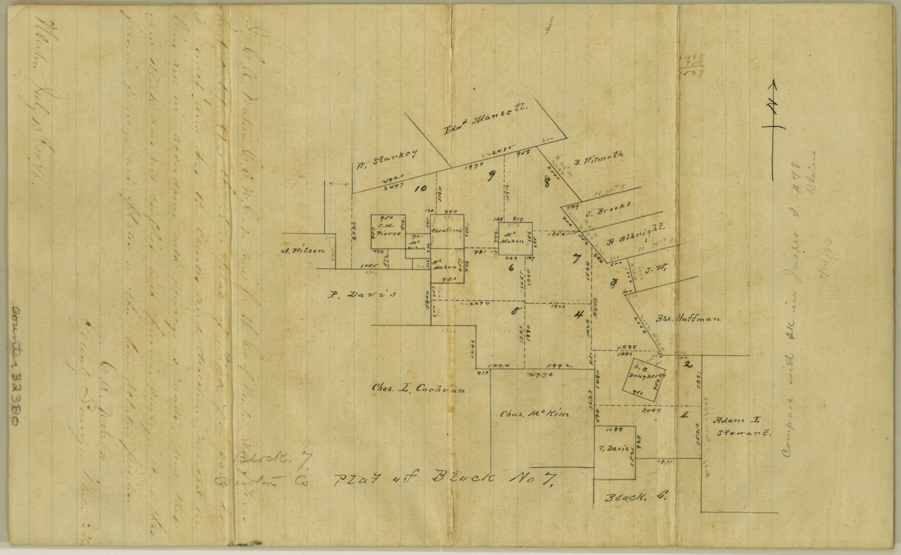
Newton County Sketch File 11
[Sketch of area southeast of Newton]
-
Map/Doc
32380
-
Collection
General Map Collection
-
Object Dates
7/13/1876 (Creation Date)
8/19/1876 (File Date)
-
People and Organizations
C.A. Nation (Surveyor/Engineer)
-
Counties
Newton
-
Subjects
Surveying Sketch File
-
Height x Width
7.9 x 12.7 inches
20.1 x 32.3 cm
-
Medium
paper, manuscript
Part of: General Map Collection
Flight Mission No. CGI-1N, Frame 219, Cameron County

Print $20.00
- Digital $50.00
Flight Mission No. CGI-1N, Frame 219, Cameron County
1955
Size 18.6 x 22.2 inches
Map/Doc 84528
Outer Continental Shelf Leasing Maps (Louisiana Offshore Operations)

Print $20.00
- Digital $50.00
Outer Continental Shelf Leasing Maps (Louisiana Offshore Operations)
1955
Size 15.9 x 10.8 inches
Map/Doc 76082
Brazos River, Koy Bridge Sheet/Mill Creek

Print $20.00
- Digital $50.00
Brazos River, Koy Bridge Sheet/Mill Creek
1933
Size 44.0 x 27.3 inches
Map/Doc 65290
Lipscomb County Rolled Sketch 2

Print $20.00
- Digital $50.00
Lipscomb County Rolled Sketch 2
1886
Size 24.1 x 30.2 inches
Map/Doc 6628
Topographical Map of the Rio Grande, Sheet No. 25

Print $20.00
- Digital $50.00
Topographical Map of the Rio Grande, Sheet No. 25
1912
Map/Doc 89549
Bandera County Sketch File 28

Print $40.00
- Digital $50.00
Bandera County Sketch File 28
Size 23.5 x 20.0 inches
Map/Doc 10897
La Salle County Sketch File A

Print $30.00
- Digital $50.00
La Salle County Sketch File A
1880
Size 8.1 x 12.5 inches
Map/Doc 29532
Map of Velasco

Print $20.00
- Digital $50.00
Map of Velasco
1906
Size 32.1 x 39.4 inches
Map/Doc 95357
Austin County Boundary File 1

Print $44.00
- Digital $50.00
Austin County Boundary File 1
Size 7.0 x 8.2 inches
Map/Doc 50223
Leon County Working Sketch 48

Print $20.00
- Digital $50.00
Leon County Working Sketch 48
1980
Size 29.2 x 33.7 inches
Map/Doc 70447
Calhoun County Rolled Sketch 14

Print $20.00
- Digital $50.00
Calhoun County Rolled Sketch 14
Size 21.9 x 40.1 inches
Map/Doc 5459
Terrell County Rolled Sketch 1

Print $20.00
- Digital $50.00
Terrell County Rolled Sketch 1
1906
Size 31.2 x 22.5 inches
Map/Doc 7924
You may also like
Map of Reeves County

Print $20.00
- Digital $50.00
Map of Reeves County
1892
Size 47.2 x 35.4 inches
Map/Doc 78401
Houston County Sketch File 1a

Print $4.00
- Digital $50.00
Houston County Sketch File 1a
Size 9.2 x 7.8 inches
Map/Doc 26742
Deaf Smith County

Print $40.00
- Digital $50.00
Deaf Smith County
1926
Size 41.4 x 54.3 inches
Map/Doc 1816
Supreme Court of the United States, October Term, 1923, No. 15, Original - The State of Oklahoma, Complainant vs. The State of Texas, Defendant, The United States, Intervener; Report of the Boundary Commissioners

Print $20.00
- Digital $50.00
Supreme Court of the United States, October Term, 1923, No. 15, Original - The State of Oklahoma, Complainant vs. The State of Texas, Defendant, The United States, Intervener; Report of the Boundary Commissioners
1923
Size 34.4 x 40.6 inches
Map/Doc 75120
Presidio County Sketch File 80

Print $23.00
- Digital $50.00
Presidio County Sketch File 80
1948
Size 9.5 x 20.3 inches
Map/Doc 34709
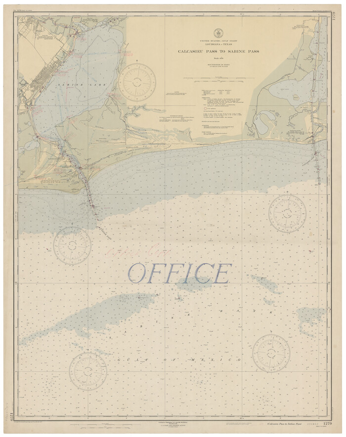
Calcasieu Pass to Sabine Pass
Print $20.00
- Digital $50.00
Calcasieu Pass to Sabine Pass
1946
Size 45.0 x 35.7 inches
Map/Doc 69807
Fort Bend County Sketch File 10

Print $20.00
- Digital $50.00
Fort Bend County Sketch File 10
Size 16.9 x 24.9 inches
Map/Doc 11501
Map of certain tidal areas in Harris and Galveston Counties showing subdivision thereof for mineral development

Print $20.00
- Digital $50.00
Map of certain tidal areas in Harris and Galveston Counties showing subdivision thereof for mineral development
1938
Size 34.3 x 26.7 inches
Map/Doc 2936

Webb County Sketch File 6-1

Print $6.00
- Digital $50.00
Webb County Sketch File 6-1
1877
Size 9.8 x 12.7 inches
Map/Doc 39737
Kerr County Boundary File 4a

Print $16.00
- Digital $50.00
Kerr County Boundary File 4a
Size 6.1 x 8.2 inches
Map/Doc 64801
Galveston County Sketch File 31

Print $20.00
- Digital $50.00
Galveston County Sketch File 31
1916
Size 23.7 x 13.6 inches
Map/Doc 11534