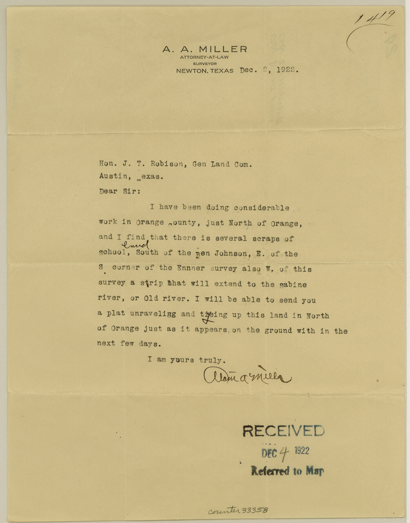
Orange County Sketch File 29
[Letter regarding several scraps of school land just north of Orange]
-
Map/Doc
33358
-
Collection
General Map Collection
-
Object Dates
12/2/1922 (Creation Date)
12/4/1922 (File Date)
-
People and Organizations
Alan A. Miller (Surveyor/Engineer)
-
Counties
Orange
-
Subjects
Surveying Sketch File
-
Height x Width
11.2 x 8.8 inches
28.5 x 22.4 cm
-
Medium
paper, print
-
Features
Sabine River
Old River
Part of: General Map Collection
Chart of the West Indies and Spanish Dominions in North America

Print $20.00
- Digital $50.00
Chart of the West Indies and Spanish Dominions in North America
1803
Size 25.6 x 39.2 inches
Map/Doc 97138
Kimble County Sketch File 32

Print $20.00
- Digital $50.00
Kimble County Sketch File 32
1957
Size 18.4 x 21.6 inches
Map/Doc 11930
Flight Mission No. BRA-16M, Frame 57, Jefferson County

Print $20.00
- Digital $50.00
Flight Mission No. BRA-16M, Frame 57, Jefferson County
1953
Size 18.3 x 22.5 inches
Map/Doc 85674
Val Verde County Rolled Sketch 38

Print $20.00
- Digital $50.00
Val Verde County Rolled Sketch 38
Size 29.8 x 19.7 inches
Map/Doc 8114
Flight Mission No. DIX-5P, Frame 104, Aransas County

Print $20.00
- Digital $50.00
Flight Mission No. DIX-5P, Frame 104, Aransas County
1956
Size 17.8 x 18.5 inches
Map/Doc 83782
Culberson County Working Sketch 49

Print $40.00
- Digital $50.00
Culberson County Working Sketch 49
1972
Size 49.2 x 37.6 inches
Map/Doc 68503
McMullen County Working Sketch 27

Print $40.00
- Digital $50.00
McMullen County Working Sketch 27
1953
Size 53.2 x 32.9 inches
Map/Doc 70728
Lipscomb County Working Sketch 1

Print $20.00
- Digital $50.00
Lipscomb County Working Sketch 1
1964
Size 30.7 x 34.1 inches
Map/Doc 70577
Harris County Rolled Sketch 76

Print $20.00
- Digital $50.00
Harris County Rolled Sketch 76
1951
Size 37.0 x 24.0 inches
Map/Doc 6113
Montgomery County Working Sketch 42

Print $20.00
- Digital $50.00
Montgomery County Working Sketch 42
1956
Size 21.3 x 32.8 inches
Map/Doc 71149
Flight Mission No. DQN-2K, Frame 195, Calhoun County

Print $20.00
- Digital $50.00
Flight Mission No. DQN-2K, Frame 195, Calhoun County
1953
Size 18.6 x 22.2 inches
Map/Doc 84333
Flight Mission No. BRA-7M, Frame 32, Jefferson County

Print $20.00
- Digital $50.00
Flight Mission No. BRA-7M, Frame 32, Jefferson County
1953
Size 18.7 x 22.4 inches
Map/Doc 85483
You may also like
Austin Empresario Colony. January 17, 1821/February 18, 1823

Print $20.00
Austin Empresario Colony. January 17, 1821/February 18, 1823
2020
Size 18.8 x 21.6 inches
Map/Doc 95978
[Blocks K3-K8, K11]
![90528, [Blocks K3-K8, K11], Twichell Survey Records](https://historictexasmaps.com/wmedia_w700/maps/90528-1.tif.jpg)
Print $3.00
- Digital $50.00
[Blocks K3-K8, K11]
Size 11.2 x 12.8 inches
Map/Doc 90528
Dimmit County Sketch File 25

Print $4.00
- Digital $50.00
Dimmit County Sketch File 25
1885
Size 12.9 x 8.6 inches
Map/Doc 21142
Brewster County Rolled Sketch 21

Print $20.00
- Digital $50.00
Brewster County Rolled Sketch 21
1907
Size 28.5 x 26.0 inches
Map/Doc 5200
Witt Addition, Subdivision out of Section 6, Block E, City of Lubbock

Print $20.00
- Digital $50.00
Witt Addition, Subdivision out of Section 6, Block E, City of Lubbock
1950
Size 9.1 x 30.9 inches
Map/Doc 92739
Township No. 4 South Range No. 14 West of the Indian Meridian

Print $4.00
- Digital $50.00
Township No. 4 South Range No. 14 West of the Indian Meridian
1875
Size 18.0 x 22.4 inches
Map/Doc 75144
Liberty County Sketch File 36a

Print $4.00
- Digital $50.00
Liberty County Sketch File 36a
Size 8.6 x 5.6 inches
Map/Doc 29974
El Paso County Rolled Sketch 44

Print $129.00
- Digital $50.00
El Paso County Rolled Sketch 44
1902
Size 10.4 x 15.5 inches
Map/Doc 44430
St. L. S.-W. Ry. of Texas, Map of Lufkin Branch in Smith County, Texas

Print $20.00
- Digital $50.00
St. L. S.-W. Ry. of Texas, Map of Lufkin Branch in Smith County, Texas
1912
Size 23.1 x 37.2 inches
Map/Doc 64694
Midland County Sketch File 7

Print $20.00
- Digital $50.00
Midland County Sketch File 7
1930
Size 33.1 x 23.7 inches
Map/Doc 12083
Map of Lampasas County

Print $40.00
- Digital $50.00
Map of Lampasas County
1900
Size 47.1 x 60.2 inches
Map/Doc 62971
Upton County Rolled Sketch 59A

Print $20.00
- Digital $50.00
Upton County Rolled Sketch 59A
Size 35.4 x 45.6 inches
Map/Doc 76422