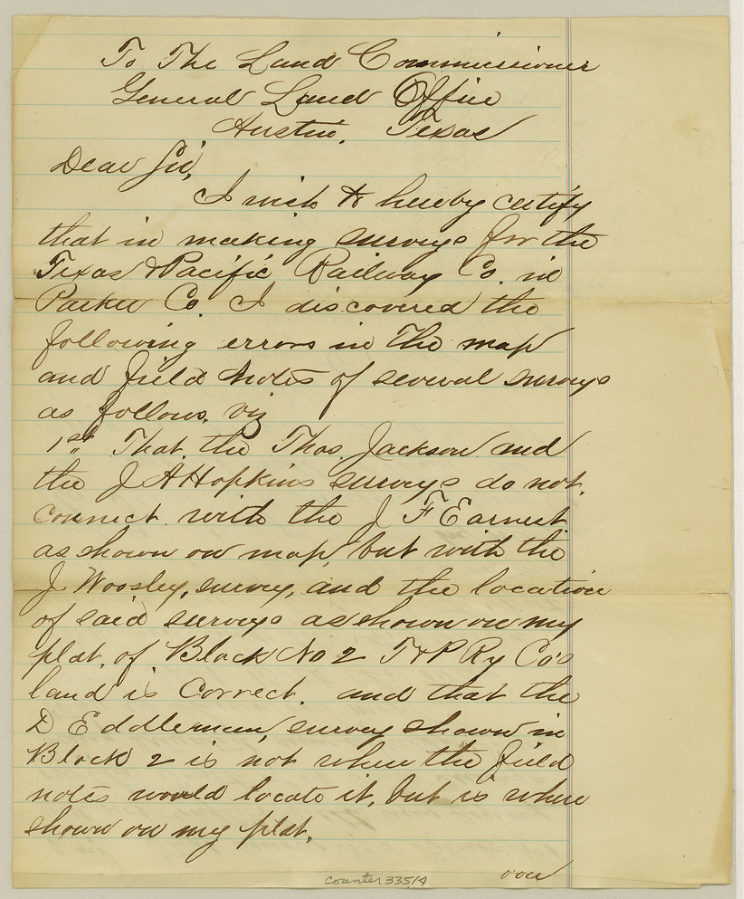
Parker County Sketch File D
[Certificate of correction and explanation]
-
Map/Doc
33514
-
Collection
General Map Collection
-
Object Dates
3/30/1874 (File Date)
-
People and Organizations
Isaac C. Terry (Surveyor/Engineer)
-
Counties
Parker
-
Subjects
Surveying Sketch File
-
Height x Width
9.9 x 8.2 inches
25.1 x 20.8 cm
-
Medium
paper, manuscript
Part of: General Map Collection
Jack County Working Sketch 3

Print $20.00
- Digital $50.00
Jack County Working Sketch 3
1940
Size 18.8 x 26.0 inches
Map/Doc 66429
San Jacinto County Sketch File 12

Print $4.00
San Jacinto County Sketch File 12
1873
Size 9.7 x 8.2 inches
Map/Doc 35720
Presidio County Rolled Sketch 100

Print $20.00
- Digital $50.00
Presidio County Rolled Sketch 100
1954
Size 30.4 x 30.2 inches
Map/Doc 7382
Bexar County Working Sketch 4

Print $20.00
- Digital $50.00
Bexar County Working Sketch 4
1941
Size 19.4 x 21.7 inches
Map/Doc 67320
Presidio County Working Sketch 92

Print $20.00
- Digital $50.00
Presidio County Working Sketch 92
1976
Size 27.1 x 23.1 inches
Map/Doc 71769
Motley County Boundary File 2

Print $10.00
- Digital $50.00
Motley County Boundary File 2
Size 7.1 x 4.3 inches
Map/Doc 57506
The Making of America - Northern Plains

The Making of America - Northern Plains
Size 20.7 x 27.3 inches
Map/Doc 95943
Blanco County Rolled Sketch 17

Print $20.00
- Digital $50.00
Blanco County Rolled Sketch 17
Size 18.0 x 23.9 inches
Map/Doc 5153
Kleberg County Rolled Sketch 10-24

Print $20.00
- Digital $50.00
Kleberg County Rolled Sketch 10-24
1952
Size 41.7 x 36.0 inches
Map/Doc 9386
Donley County Sketch File 4

Print $28.00
- Digital $50.00
Donley County Sketch File 4
1881
Size 12.8 x 8.3 inches
Map/Doc 21219
Hemphill County Working Sketch 18

Print $20.00
- Digital $50.00
Hemphill County Working Sketch 18
1972
Size 33.7 x 41.6 inches
Map/Doc 66113
Flight Mission No. DAH-9M, Frame 164, Orange County

Print $20.00
- Digital $50.00
Flight Mission No. DAH-9M, Frame 164, Orange County
1953
Size 18.6 x 22.3 inches
Map/Doc 86863
You may also like
Right-of-Way and Track Map, Texas State Railroad operated by the T. and N.O. R.R. Co.

Print $40.00
- Digital $50.00
Right-of-Way and Track Map, Texas State Railroad operated by the T. and N.O. R.R. Co.
1917
Size 25.2 x 56.1 inches
Map/Doc 64171
Nolan County Sketch File 8

Print $2.00
- Digital $50.00
Nolan County Sketch File 8
Size 11.3 x 8.8 inches
Map/Doc 32464
Crockett County Working Sketch 97

Print $20.00
- Digital $50.00
Crockett County Working Sketch 97
1979
Size 39.4 x 37.4 inches
Map/Doc 68430
Ector County Sketch File 1

Print $20.00
- Digital $50.00
Ector County Sketch File 1
1931
Size 17.1 x 18.0 inches
Map/Doc 11415
Brewster County Sketch File FN-32

Print $8.00
- Digital $50.00
Brewster County Sketch File FN-32
Size 11.1 x 8.7 inches
Map/Doc 15854
The M. K. and T., Missouri, Kansas & Texas Railway

Print $20.00
- Digital $50.00
The M. K. and T., Missouri, Kansas & Texas Railway
1890
Size 25.0 x 27.9 inches
Map/Doc 95807
Northern Part of Laguna Madre

Print $20.00
- Digital $50.00
Northern Part of Laguna Madre
1982
Size 44.2 x 35.0 inches
Map/Doc 73530
Plains Addition to Seagraves, Gaines County, Texas

Print $20.00
- Digital $50.00
Plains Addition to Seagraves, Gaines County, Texas
1948
Size 30.0 x 33.0 inches
Map/Doc 92691
General Highway Map, Floyd County, Texas

Print $20.00
General Highway Map, Floyd County, Texas
1940
Size 25.1 x 18.7 inches
Map/Doc 79091
Stonewall County Working Sketch Graphic Index - sheet A

Print $20.00
- Digital $50.00
Stonewall County Working Sketch Graphic Index - sheet A
1933
Size 43.3 x 36.2 inches
Map/Doc 76704
Flight Mission No. CRC-3R, Frame 12, Chambers County

Print $20.00
- Digital $50.00
Flight Mission No. CRC-3R, Frame 12, Chambers County
1956
Size 18.4 x 22.2 inches
Map/Doc 84786
Concho County Working Sketch 25

Print $20.00
- Digital $50.00
Concho County Working Sketch 25
1982
Size 32.3 x 38.1 inches
Map/Doc 68207