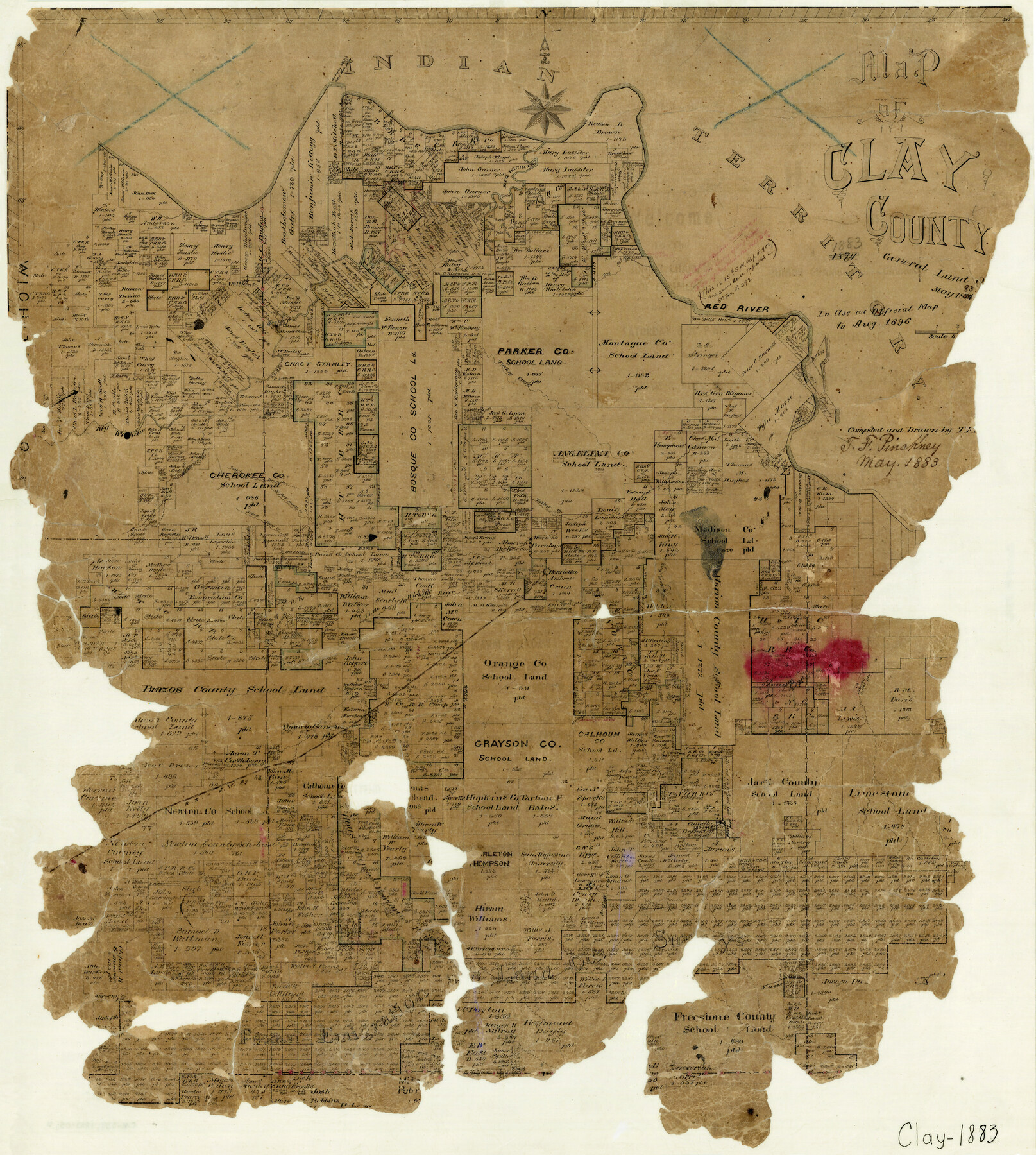
Map of Clay County
-
Map/Doc
3396
-
Collection
General Map Collection
-
Object Dates
5/1883 (Creation Date)
-
People and Organizations
Theo. F. Pinckney (Draftsman)
-
Counties
Clay
-
Subjects
County
-
Height x Width
26.0 x 23.3 inches
66.0 x 59.2 cm
-
Comments
Note on map: "In use until August 1896".
-
Features
Big Wichita River
Red River
Turkey Creek
Valley Creek
Road to Henrietta
North Fork of Duck Creek
South Fork of Duck Creek
Holliday Creek
East Fork of Valley Creek
Henrietta
Little Wichita River
Lake Creek
RR&SW
Part of: General Map Collection
Shackelford County Sketch File 8

Print $44.00
- Digital $50.00
Shackelford County Sketch File 8
1936
Size 11.5 x 8.8 inches
Map/Doc 59290
Victoria County Rolled Sketch 2

Print $40.00
- Digital $50.00
Victoria County Rolled Sketch 2
1940
Size 61.1 x 18.5 inches
Map/Doc 10093
Erath County Rolled Sketch 2B

Print $20.00
- Digital $50.00
Erath County Rolled Sketch 2B
Size 15.5 x 20.9 inches
Map/Doc 5863
Galveston County NRC Article 33.136 Sketch 27

Print $126.00
- Digital $50.00
Galveston County NRC Article 33.136 Sketch 27
2003
Size 24.4 x 36.2 inches
Map/Doc 81970
El Paso County Rolled Sketch 52

Print $20.00
- Digital $50.00
El Paso County Rolled Sketch 52
1929
Size 19.1 x 24.3 inches
Map/Doc 5850
Robertson County Working Sketch 20

Print $40.00
- Digital $50.00
Robertson County Working Sketch 20
2005
Size 27.5 x 50.0 inches
Map/Doc 83583
Flight Mission No. BRA-7M, Frame 127, Jefferson County

Print $20.00
- Digital $50.00
Flight Mission No. BRA-7M, Frame 127, Jefferson County
1953
Size 18.5 x 22.3 inches
Map/Doc 85521

Tom Green County Sketch File 50

Print $20.00
- Digital $50.00
Tom Green County Sketch File 50
1884
Size 25.4 x 34.5 inches
Map/Doc 12442
Anderson County Rolled Sketch 14

Print $20.00
- Digital $50.00
Anderson County Rolled Sketch 14
1997
Size 30.1 x 36.5 inches
Map/Doc 77159

Atascosa County Rolled Sketch 25

Print $20.00
- Digital $50.00
Atascosa County Rolled Sketch 25
Size 25.2 x 20.5 inches
Map/Doc 93551
You may also like
Val Verde County Boundary File 103a

Print $8.00
- Digital $50.00
Val Verde County Boundary File 103a
Size 14.4 x 8.8 inches
Map/Doc 59600
Intracoastal Waterway in Texas - Corpus Christi to Point Isabel including Arroyo Colorado to Mo. Pac. R.R. Bridge Near Harlingen

Print $20.00
- Digital $50.00
Intracoastal Waterway in Texas - Corpus Christi to Point Isabel including Arroyo Colorado to Mo. Pac. R.R. Bridge Near Harlingen
1933
Size 28.1 x 41.0 inches
Map/Doc 61844
Town of Beaumont in Jefferson County, Texas

Print $20.00
Town of Beaumont in Jefferson County, Texas
1850
Size 17.6 x 24.3 inches
Map/Doc 76267
Potter County Sketch File 14

Print $20.00
- Digital $50.00
Potter County Sketch File 14
Size 16.5 x 22.5 inches
Map/Doc 12200
Atascosa County Sketch File 12

Print $4.00
- Digital $50.00
Atascosa County Sketch File 12
1862
Size 14.4 x 8.3 inches
Map/Doc 13769
Morris County Rolled Sketch 2A

Print $20.00
- Digital $50.00
Morris County Rolled Sketch 2A
Size 13.4 x 19.1 inches
Map/Doc 10231
El Paso County Rolled Sketch 48

Print $20.00
- Digital $50.00
El Paso County Rolled Sketch 48
1960
Size 15.4 x 18.3 inches
Map/Doc 5834
Flight Mission No. CUG-3P, Frame 35, Kleberg County

Print $20.00
- Digital $50.00
Flight Mission No. CUG-3P, Frame 35, Kleberg County
1956
Size 18.6 x 22.3 inches
Map/Doc 86240
Glasscock County Sketch File 21

Print $20.00
- Digital $50.00
Glasscock County Sketch File 21
1936
Size 23.1 x 20.3 inches
Map/Doc 11564
Fort Bend County Sketch File 31

Print $10.00
- Digital $50.00
Fort Bend County Sketch File 31
1940
Size 13.3 x 8.7 inches
Map/Doc 22997
Fractional Township No. 8 South Range No. 15 East of the Indian Meridian, Indian Territory

Print $20.00
- Digital $50.00
Fractional Township No. 8 South Range No. 15 East of the Indian Meridian, Indian Territory
1896
Size 19.1 x 24.3 inches
Map/Doc 75227
Val Verde County Sketch File Z6

Print $20.00
- Digital $50.00
Val Verde County Sketch File Z6
Size 29.3 x 26.2 inches
Map/Doc 10425