Shackelford County Sketch File 8
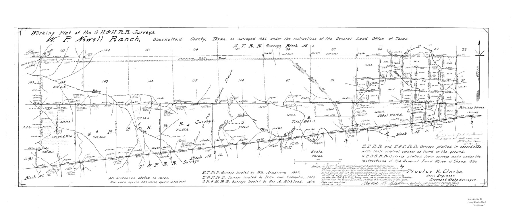
[Letter and sketch from Proctor K. Clarke to W.P. Newell regarding G. H. & H. R.R. Co. surveys between T. & P. Ry. Co. Block 12 and E. T. R.R. Block 1]
-
Map/Doc
59290
-
Collection
General Map Collection
-
Object Dates
4/15/1936 (Creation Date)
4/23/1936 (File Date)
-
People and Organizations
Proctor K. Clarke (Surveyor/Engineer)
-
Counties
Shackelford
-
Subjects
Surveying Sketch File
-
Height x Width
11.5 x 8.8 inches
29.2 x 22.4 cm
-
Medium
paper, print
-
Comments
See Shackelford County Rolled Sketch 2 (75935) for sketch.
-
Features
Ft. Griffin and Ft. Concho Military Road
Abandoned Public Road
Lake Fork of North Hubbard Creek
Keener Branch of Hubbard Creek
Bluff Creek
Middle Fork of North Hubbard Creek
Related maps
Shackelford County Rolled Sketch 2

Print $40.00
- Digital $50.00
Shackelford County Rolled Sketch 2
Size 18.9 x 51.9 inches
Map/Doc 75935
Part of: General Map Collection
Zapata County Sketch File 13

Print $4.00
- Digital $50.00
Zapata County Sketch File 13
1930
Size 11.3 x 8.8 inches
Map/Doc 40952
Map of section no. 3 of a survey of Padre Island made for the Office of the Attorney General of the State of Texas

Print $40.00
- Digital $50.00
Map of section no. 3 of a survey of Padre Island made for the Office of the Attorney General of the State of Texas
1941
Size 49.6 x 40.2 inches
Map/Doc 2259
Smith County Working Sketch 19

Print $20.00
- Digital $50.00
Smith County Working Sketch 19
1997
Size 31.4 x 36.5 inches
Map/Doc 63904
Uvalde County

Print $20.00
- Digital $50.00
Uvalde County
1915
Size 43.4 x 46.4 inches
Map/Doc 63092
Flight Mission No. CUG-3P, Frame 32, Kleberg County

Print $20.00
- Digital $50.00
Flight Mission No. CUG-3P, Frame 32, Kleberg County
1956
Size 18.8 x 22.3 inches
Map/Doc 86237
Intracoastal Waterway in Texas - Corpus Christi to Point Isabel including Arroyo Colorado to Mo. Pac. R.R. Bridge Near Harlingen

Print $20.00
- Digital $50.00
Intracoastal Waterway in Texas - Corpus Christi to Point Isabel including Arroyo Colorado to Mo. Pac. R.R. Bridge Near Harlingen
1933
Size 28.2 x 41.3 inches
Map/Doc 61873
Flight Mission No. DIX-5P, Frame 144, Aransas County

Print $20.00
- Digital $50.00
Flight Mission No. DIX-5P, Frame 144, Aransas County
1956
Size 17.2 x 17.6 inches
Map/Doc 83805
Flight Mission No. DQO-8K, Frame 52, Galveston County

Print $20.00
- Digital $50.00
Flight Mission No. DQO-8K, Frame 52, Galveston County
1952
Size 18.6 x 22.2 inches
Map/Doc 85159
Freestone County Sketch File 8

Print $4.00
- Digital $50.00
Freestone County Sketch File 8
1859
Size 5.8 x 8.1 inches
Map/Doc 23054
Andrews County Rolled Sketch 25

Print $20.00
- Digital $50.00
Andrews County Rolled Sketch 25
1947
Size 21.9 x 32.7 inches
Map/Doc 77171
Concho County Sketch File 7

Print $6.00
- Digital $50.00
Concho County Sketch File 7
1857
Size 16.4 x 11.5 inches
Map/Doc 19129
Jefferson County Sketch File 53

Print $36.00
- Digital $50.00
Jefferson County Sketch File 53
1973
Size 11.2 x 8.9 inches
Map/Doc 28255
You may also like
Angelina County Working Sketch 46

Print $20.00
- Digital $50.00
Angelina County Working Sketch 46
1976
Size 31.2 x 31.3 inches
Map/Doc 67129
Throckmorton County Rolled Sketch 6A

Print $20.00
- Digital $50.00
Throckmorton County Rolled Sketch 6A
2004
Size 20.3 x 24.3 inches
Map/Doc 82489
Map of Survey in Dimmit and Webb Counties

Print $40.00
- Digital $50.00
Map of Survey in Dimmit and Webb Counties
1913
Size 31.3 x 71.0 inches
Map/Doc 75829
Motley County Boundary File 1a

Print $8.00
- Digital $50.00
Motley County Boundary File 1a
Size 11.2 x 8.5 inches
Map/Doc 57501
Map of the post of Fort Brown, Brownsville, Texas

Print $20.00
Map of the post of Fort Brown, Brownsville, Texas
1877
Size 24.0 x 33.9 inches
Map/Doc 93560
Marion County Rolled Sketch 9A

Print $20.00
- Digital $50.00
Marion County Rolled Sketch 9A
2001
Size 22.9 x 22.9 inches
Map/Doc 76419
Crockett County Sketch File 76

Print $2.00
- Digital $50.00
Crockett County Sketch File 76
1933
Size 11.2 x 8.6 inches
Map/Doc 19876
Trinity River, Levee Improvement Districts, Widths of Floodways/Pilot Grove Creek and East Fork Trinity River

Print $6.00
- Digital $50.00
Trinity River, Levee Improvement Districts, Widths of Floodways/Pilot Grove Creek and East Fork Trinity River
1920
Size 33.0 x 17.1 inches
Map/Doc 65259
[Map showing J. H. Gibson Blocks D and DD and Double Lake Corner]
![92015, [Map showing J. H. Gibson Blocks D and DD and Double Lake Corner], Twichell Survey Records](https://historictexasmaps.com/wmedia_w700/maps/92015-1.tif.jpg)
Print $20.00
- Digital $50.00
[Map showing J. H. Gibson Blocks D and DD and Double Lake Corner]
Size 36.4 x 33.6 inches
Map/Doc 92015

Presidio County Sketch File 105

Print $20.00
- Digital $50.00
Presidio County Sketch File 105
Size 13.1 x 20.6 inches
Map/Doc 82962
Harris County Historic Topographic 32

Print $20.00
- Digital $50.00
Harris County Historic Topographic 32
1916
Size 29.3 x 21.6 inches
Map/Doc 65843