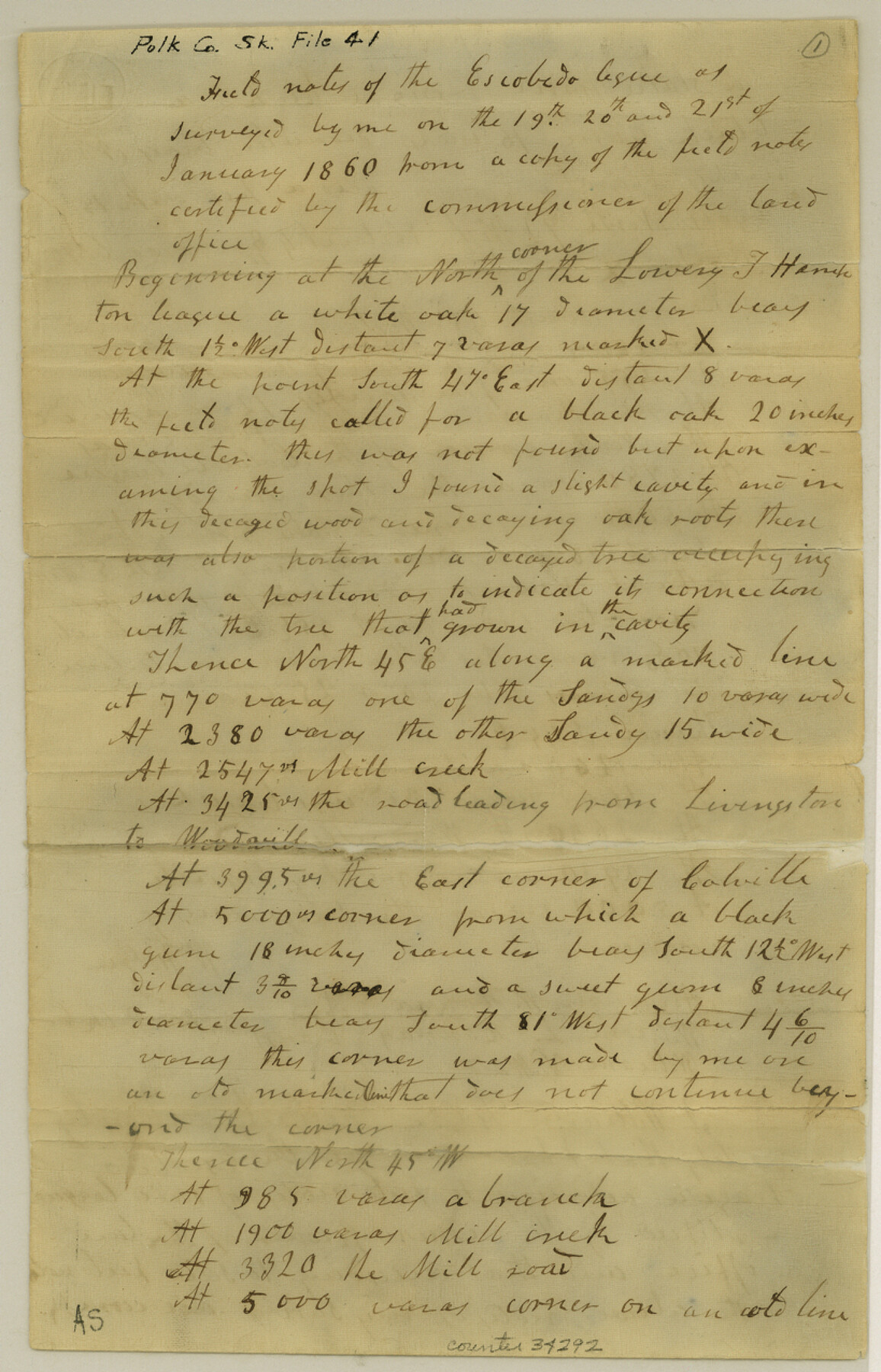
Polk County Sketch File 41
[Field notes of Escobeda league]
-
Map/Doc
34292
-
Collection
General Map Collection
-
Object Dates
1860 (File Date)
1/21/1860 (Survey Date)
-
People and Organizations
William H. Gee (Surveyor/Engineer)
Alexander W. Hanna (Chainman/Field Personnel)
William L. Hannay (Chainman/Field Personnel)
William V. Ward (Chainman/Field Personnel)
-
Counties
Polk
-
Subjects
Surveying Sketch File
-
Height x Width
12.7 x 8.2 inches
32.3 x 20.8 cm
-
Medium
paper, manuscript
-
Features
Livingston to Woodville Road
Mill Creek
Sandy Creek
Reddings Branch
Part of: General Map Collection
Houston County Sketch File 12

Print $4.00
- Digital $50.00
Houston County Sketch File 12
1849
Size 8.2 x 14.7 inches
Map/Doc 26773
Clay County Boundary File 4

Print $14.00
- Digital $50.00
Clay County Boundary File 4
Size 10.1 x 6.7 inches
Map/Doc 51366
Orange County Rolled Sketch 16

Print $20.00
- Digital $50.00
Orange County Rolled Sketch 16
Size 42.2 x 30.4 inches
Map/Doc 41813
San Patricio County Sketch File 15A

Print $4.00
San Patricio County Sketch File 15A
1883
Size 11.0 x 8.5 inches
Map/Doc 97195
Presidio County Working Sketch 61

Print $20.00
- Digital $50.00
Presidio County Working Sketch 61
1957
Size 40.0 x 35.0 inches
Map/Doc 71738
Morris County Rolled Sketch 2A

Print $20.00
- Digital $50.00
Morris County Rolled Sketch 2A
Size 22.5 x 17.6 inches
Map/Doc 10230
Crosby County Sketch File 16

Print $20.00
- Digital $50.00
Crosby County Sketch File 16
1904
Size 31.7 x 9.6 inches
Map/Doc 11251
Pecos County Working Sketch 122

Print $40.00
- Digital $50.00
Pecos County Working Sketch 122
1973
Size 51.9 x 36.7 inches
Map/Doc 71595
Mills County Sketch File 4

Print $4.00
- Digital $50.00
Mills County Sketch File 4
Size 8.8 x 8.3 inches
Map/Doc 31648
Terry County Sketch File 9

Print $4.00
- Digital $50.00
Terry County Sketch File 9
1917
Size 14.4 x 8.8 inches
Map/Doc 38032
Childress County Sketch File 15a

Print $4.00
- Digital $50.00
Childress County Sketch File 15a
Size 8.6 x 11.7 inches
Map/Doc 18303
Crockett County Sketch File 42

Print $28.00
- Digital $50.00
Crockett County Sketch File 42
Size 12.8 x 8.4 inches
Map/Doc 19755
You may also like
[Capitol Leagues 217-239]
![90668, [Capitol Leagues 217-239], Twichell Survey Records](https://historictexasmaps.com/wmedia_w700/maps/90668-1.tif.jpg)
Print $20.00
- Digital $50.00
[Capitol Leagues 217-239]
Size 26.9 x 26.6 inches
Map/Doc 90668
General Highway Map, Bastrop County, Texas

Print $20.00
General Highway Map, Bastrop County, Texas
1940
Size 18.6 x 25.2 inches
Map/Doc 79012
Duval County Boundary File 2

Print $32.00
- Digital $50.00
Duval County Boundary File 2
Size 12.4 x 8.1 inches
Map/Doc 52703
Cameron County Sketch File 8

Print $73.00
- Digital $50.00
Cameron County Sketch File 8
1982
Size 11.4 x 8.9 inches
Map/Doc 17124
Flight Mission No. DCL-6C, Frame 95, Kenedy County

Print $20.00
- Digital $50.00
Flight Mission No. DCL-6C, Frame 95, Kenedy County
1943
Size 18.6 x 22.3 inches
Map/Doc 85925
Flight Mission No. CGI-3N, Frame 177, Cameron County

Print $20.00
- Digital $50.00
Flight Mission No. CGI-3N, Frame 177, Cameron County
1954
Size 18.5 x 22.3 inches
Map/Doc 84641
Hudspeth County Rolled Sketch 69

Print $20.00
- Digital $50.00
Hudspeth County Rolled Sketch 69
1973
Size 13.3 x 20.5 inches
Map/Doc 7716
Harris County Sketch File 104

Print $2.00
- Digital $50.00
Harris County Sketch File 104
1992
Size 11.2 x 8.9 inches
Map/Doc 25974
Wood County Sketch File 5

Print $4.00
- Digital $50.00
Wood County Sketch File 5
1848
Size 10.7 x 9.0 inches
Map/Doc 40637
Atascosa County Sketch File 8a

Print $4.00
- Digital $50.00
Atascosa County Sketch File 8a
Size 13.9 x 8.4 inches
Map/Doc 13761
Crockett County Sketch File 51a

Print $10.00
- Digital $50.00
Crockett County Sketch File 51a
1922
Size 14.3 x 8.8 inches
Map/Doc 19812
Trinity River, Boyd Crossing Sheet/Chambers Creek

Print $20.00
- Digital $50.00
Trinity River, Boyd Crossing Sheet/Chambers Creek
1931
Size 17.5 x 43.1 inches
Map/Doc 65238