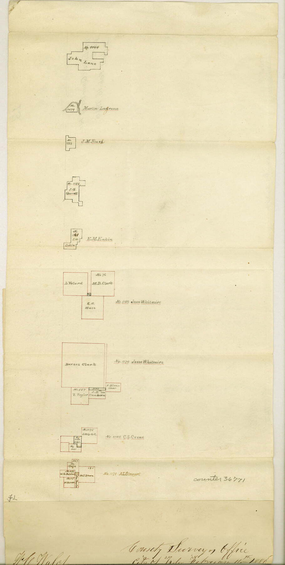
Smith County Sketch File 13
[Quarterly report from County Surveyor]
-
Map/Doc
36771
-
Collection
General Map Collection
-
Object Dates
2/16/1880 (Creation Date)
-
People and Organizations
Ira Ellis (Surveyor/Engineer)
-
Counties
Smith
-
Subjects
Surveying Sketch File
-
Height x Width
16.7 x 8.4 inches
42.4 x 21.3 cm
-
Medium
paper, manuscript
Part of: General Map Collection
Liberty County Working Sketch 28

Print $20.00
- Digital $50.00
Liberty County Working Sketch 28
1942
Size 22.4 x 23.2 inches
Map/Doc 70487
Sketch of North Line of T&P Eighty Mile Reserve

Print $20.00
- Digital $50.00
Sketch of North Line of T&P Eighty Mile Reserve
1914
Size 43.0 x 9.8 inches
Map/Doc 2245
Erath County Working Sketch 40

Print $20.00
- Digital $50.00
Erath County Working Sketch 40
1977
Size 26.2 x 14.9 inches
Map/Doc 69121
Reeves County Rolled Sketch 14

Print $20.00
- Digital $50.00
Reeves County Rolled Sketch 14
Size 17.7 x 21.8 inches
Map/Doc 7482

Hudspeth County Rolled Sketch 41

Print $40.00
- Digital $50.00
Hudspeth County Rolled Sketch 41
1947
Size 11.3 x 96.3 inches
Map/Doc 9214
Rusk County Working Sketch 29a

Print $20.00
- Digital $50.00
Rusk County Working Sketch 29a
1933
Size 18.1 x 25.8 inches
Map/Doc 63665
Coleman County Rolled Sketch 2

Print $20.00
- Digital $50.00
Coleman County Rolled Sketch 2
Size 18.3 x 24.9 inches
Map/Doc 5528
Edwards County Rolled Sketch JF

Print $20.00
- Digital $50.00
Edwards County Rolled Sketch JF
1915
Size 25.2 x 30.5 inches
Map/Doc 5819
[Sketch for Mineral Applications 26885-6 - Reagan and Crockett Cos., W. H. Bland]
![65672, [Sketch for Mineral Applications 26885-6 - Reagan and Crockett Cos., W. H. Bland], General Map Collection](https://historictexasmaps.com/wmedia_w700/maps/65672-1.tif.jpg)
Print $40.00
- Digital $50.00
[Sketch for Mineral Applications 26885-6 - Reagan and Crockett Cos., W. H. Bland]
Size 51.1 x 37.3 inches
Map/Doc 65672
Clay County Boundary File 18

Print $12.00
- Digital $50.00
Clay County Boundary File 18
Size 14.2 x 8.5 inches
Map/Doc 51437
McCulloch County

Print $40.00
- Digital $50.00
McCulloch County
1904
Size 49.2 x 35.5 inches
Map/Doc 66921
You may also like
Calhoun County Rolled Sketch 26

Print $20.00
- Digital $50.00
Calhoun County Rolled Sketch 26
1941
Size 10.9 x 39.9 inches
Map/Doc 5374
Roberts County Rolled Sketch 3

Print $40.00
- Digital $50.00
Roberts County Rolled Sketch 3
Size 38.0 x 49.7 inches
Map/Doc 8356
[Upton County Sketch]
![5043, [Upton County Sketch], Maddox Collection](https://historictexasmaps.com/wmedia_w700/maps/5043-1.tif.jpg)
Print $40.00
- Digital $50.00
[Upton County Sketch]
Size 19.2 x 60.3 inches
Map/Doc 5043
Irion County Boundary File 4

Print $23.00
- Digital $50.00
Irion County Boundary File 4
Size 11.2 x 8.8 inches
Map/Doc 55350
Floyd County Rolled Sketch V

Print $35.00
- Digital $50.00
Floyd County Rolled Sketch V
1918
Size 11.2 x 8.8 inches
Map/Doc 44548
King County Survey made by A.C. Tackitt and W.D. Twichell

Print $20.00
- Digital $50.00
King County Survey made by A.C. Tackitt and W.D. Twichell
1916
Size 27.5 x 25.1 inches
Map/Doc 5069
Howard County Boundary File 2a

Print $9.00
- Digital $50.00
Howard County Boundary File 2a
Size 14.6 x 11.3 inches
Map/Doc 55118
Tom Green County Sketch File 3

Print $20.00
- Digital $50.00
Tom Green County Sketch File 3
Size 29.7 x 40.5 inches
Map/Doc 10400
Flight Mission No. CGI-3N, Frame 142, Cameron County

Print $20.00
- Digital $50.00
Flight Mission No. CGI-3N, Frame 142, Cameron County
1954
Size 18.7 x 22.3 inches
Map/Doc 84615
Gillespie County Working Sketch 7

Print $40.00
- Digital $50.00
Gillespie County Working Sketch 7
1984
Size 57.5 x 43.2 inches
Map/Doc 63170
Terrell County Sketch File 22A

Print $20.00
- Digital $50.00
Terrell County Sketch File 22A
Size 21.7 x 11.4 inches
Map/Doc 12422
Brewster County Sketch File NS-4a

Print $13.00
- Digital $50.00
Brewster County Sketch File NS-4a
Size 9.3 x 14.2 inches
Map/Doc 15953