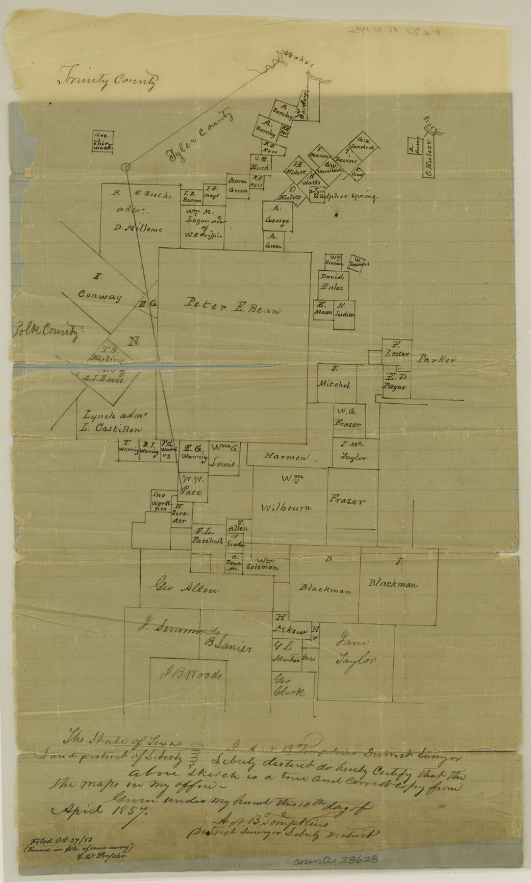
Tyler County Sketch File 4
[Sketch of area in the northwest part of county]
-
Map/Doc
38628
-
Collection
General Map Collection
-
Object Dates
4/10/1857 (Creation Date)
10/27/1858 (File Date)
-
People and Organizations
A.N.B. Tompkins (Surveyor/Engineer)
-
Counties
Tyler Polk
-
Subjects
Surveying Sketch File
-
Height x Width
13.9 x 8.4 inches
35.3 x 21.3 cm
-
Medium
paper, manuscript
-
Features
Neches River
Sulphur Spring
Caddo Creek
Part of: General Map Collection
Menard County

Print $20.00
- Digital $50.00
Menard County
1942
Size 42.2 x 44.4 inches
Map/Doc 95588
Travis County Sketch File ABC

Print $20.00
- Digital $50.00
Travis County Sketch File ABC
Size 23.8 x 19.0 inches
Map/Doc 12480
Montgomery County Rolled Sketch 50

Print $20.00
- Digital $50.00
Montgomery County Rolled Sketch 50
2016
Size 24.1 x 35.7 inches
Map/Doc 95685
Flight Mission No. CRC-4R, Frame 64, Chambers County

Print $20.00
- Digital $50.00
Flight Mission No. CRC-4R, Frame 64, Chambers County
1956
Size 18.7 x 22.3 inches
Map/Doc 84868
Outer Continental Shelf Leasing Maps (Louisiana Offshore Operations)

Print $20.00
- Digital $50.00
Outer Continental Shelf Leasing Maps (Louisiana Offshore Operations)
1971
Size 18.7 x 13.9 inches
Map/Doc 76102
Tom Green County Working Sketch 13

Print $20.00
- Digital $50.00
Tom Green County Working Sketch 13
1981
Size 34.3 x 26.4 inches
Map/Doc 69382
Midland County Rolled Sketch T

Print $20.00
- Digital $50.00
Midland County Rolled Sketch T
1933
Size 15.9 x 21.4 inches
Map/Doc 6772
Map of the County of Cameron, Texas

Print $40.00
- Digital $50.00
Map of the County of Cameron, Texas
1884
Size 54.7 x 34.5 inches
Map/Doc 3141
Galveston County Rolled Sketch 24

Print $20.00
- Digital $50.00
Galveston County Rolled Sketch 24
1973
Size 28.1 x 25.6 inches
Map/Doc 5958
Loving County Working Sketch 15

Print $20.00
- Digital $50.00
Loving County Working Sketch 15
1973
Size 47.3 x 34.5 inches
Map/Doc 70648
Plan of the Battle of Buena-Vista fought February 22nd and 23rd, 1847

Print $20.00
- Digital $50.00
Plan of the Battle of Buena-Vista fought February 22nd and 23rd, 1847
1847
Size 17.8 x 21.5 inches
Map/Doc 94112
Lynn County Boundary File 2

Print $6.00
- Digital $50.00
Lynn County Boundary File 2
Size 11.1 x 8.7 inches
Map/Doc 56620
You may also like
[Sections 59-70, I. & G. N. Block 1 and Runnels County School Land League 3]
![91680, [Sections 59-70, I. & G. N. Block 1 and Runnels County School Land League 3], Twichell Survey Records](https://historictexasmaps.com/wmedia_w700/maps/91680-1.tif.jpg)
Print $20.00
- Digital $50.00
[Sections 59-70, I. & G. N. Block 1 and Runnels County School Land League 3]
Size 22.7 x 20.4 inches
Map/Doc 91680
Zavala County

Print $20.00
- Digital $50.00
Zavala County
1977
Size 36.6 x 41.6 inches
Map/Doc 77468
San Saba County Sketch File 13

Print $20.00
- Digital $50.00
San Saba County Sketch File 13
1890
Size 20.9 x 19.2 inches
Map/Doc 12291
Baylor County Sketch File 2

Print $10.00
- Digital $50.00
Baylor County Sketch File 2
Size 7.8 x 9.9 inches
Map/Doc 14119
Flight Mission No. DAG-24K, Frame 49, Matagorda County

Print $20.00
- Digital $50.00
Flight Mission No. DAG-24K, Frame 49, Matagorda County
1953
Size 18.5 x 22.2 inches
Map/Doc 86536
El Paso County Working Sketch 50

Print $20.00
- Digital $50.00
El Paso County Working Sketch 50
1991
Size 25.9 x 27.7 inches
Map/Doc 69072
W. Alvin Lloyd's Southern Rail-Road Map

Print $20.00
- Digital $50.00
W. Alvin Lloyd's Southern Rail-Road Map
1863
Size 18.4 x 23.7 inches
Map/Doc 97496
[Blocks 44 and 6T and vicinity]
![91490, [Blocks 44 and 6T and vicinity], Twichell Survey Records](https://historictexasmaps.com/wmedia_w700/maps/91490-1.tif.jpg)
Print $20.00
- Digital $50.00
[Blocks 44 and 6T and vicinity]
Size 29.4 x 17.4 inches
Map/Doc 91490
Galveston County Rolled Sketch JR

Print $20.00
- Digital $50.00
Galveston County Rolled Sketch JR
1938
Size 37.5 x 36.7 inches
Map/Doc 9086
Montgomery County Working Sketch 40

Print $20.00
- Digital $50.00
Montgomery County Working Sketch 40
1954
Size 18.1 x 23.3 inches
Map/Doc 71147
Maverick County Sketch File 2

Print $40.00
- Digital $50.00
Maverick County Sketch File 2
1875
Size 18.2 x 14.0 inches
Map/Doc 31031
Jefferson County NRC Article 33.136 Location Key Sheet

Print $20.00
- Digital $50.00
Jefferson County NRC Article 33.136 Location Key Sheet
1970
Size 27.0 x 23.0 inches
Map/Doc 77028