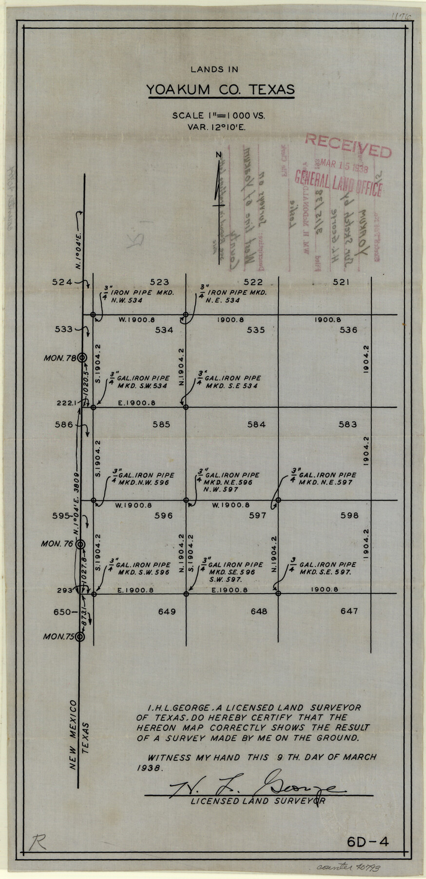
Yoakum County Sketch File 15
[Sketch of surveys on west line of Yoakum County]
-
Map/Doc
40793
-
Collection
General Map Collection
-
Object Dates
1938/3/9 (Creation Date)
1938/3/15 (File Date)
1938/3/9 (Creation Date)
1938/3/15 (File Date)
-
People and Organizations
H.L. George (Surveyor/Engineer)
-
Counties
Yoakum
-
Subjects
Surveying Sketch File
-
Height x Width
18.0 x 8.8 inches
45.7 x 22.4 cm
-
Medium
paper, manuscript
Part of: General Map Collection
Brooks County Rolled Sketch 22

Print $20.00
- Digital $50.00
Brooks County Rolled Sketch 22
1943
Size 15.1 x 32.2 inches
Map/Doc 5343
Cooke County Working Sketch 28

Print $20.00
- Digital $50.00
Cooke County Working Sketch 28
1976
Size 28.4 x 34.1 inches
Map/Doc 68265
Flight Mission No. CLL-3N, Frame 32, Willacy County

Print $20.00
- Digital $50.00
Flight Mission No. CLL-3N, Frame 32, Willacy County
1954
Size 18.4 x 22.1 inches
Map/Doc 87088
[Surveys by Brown in Austin's Little Colony along the Colorado River and Walnut Creek]
![196, [Surveys by Brown in Austin's Little Colony along the Colorado River and Walnut Creek], General Map Collection](https://historictexasmaps.com/wmedia_w700/maps/196.tif.jpg)
Print $20.00
- Digital $50.00
[Surveys by Brown in Austin's Little Colony along the Colorado River and Walnut Creek]
1832
Size 33.2 x 23.3 inches
Map/Doc 196
Flight Mission No. BRE-1P, Frame 32, Nueces County

Print $20.00
- Digital $50.00
Flight Mission No. BRE-1P, Frame 32, Nueces County
1956
Size 18.4 x 22.6 inches
Map/Doc 86628
[F. W. & D. C. Ry. Co. Alignment and Right of Way Map, Clay County]
![64727, [F. W. & D. C. Ry. Co. Alignment and Right of Way Map, Clay County], General Map Collection](https://historictexasmaps.com/wmedia_w700/maps/64727-1.tif.jpg)
Print $20.00
- Digital $50.00
[F. W. & D. C. Ry. Co. Alignment and Right of Way Map, Clay County]
1927
Size 18.6 x 11.7 inches
Map/Doc 64727
Southern Pacific Transportation Company Right of Way and Track Map - Main Line

Print $40.00
- Digital $50.00
Southern Pacific Transportation Company Right of Way and Track Map - Main Line
1918
Size 25.4 x 57.6 inches
Map/Doc 82858
Flight Mission No. DQN-1K, Frame 118, Calhoun County

Print $20.00
- Digital $50.00
Flight Mission No. DQN-1K, Frame 118, Calhoun County
1953
Size 18.5 x 22.2 inches
Map/Doc 84184
Grayson County Sketch File 14

Print $23.00
- Digital $50.00
Grayson County Sketch File 14
1873
Size 14.0 x 12.0 inches
Map/Doc 24482
Flight Mission No. DAG-24K, Frame 37, Matagorda County

Print $20.00
- Digital $50.00
Flight Mission No. DAG-24K, Frame 37, Matagorda County
1953
Size 18.5 x 22.2 inches
Map/Doc 86524
Tarrant County Rolled Sketch 2

Print $40.00
- Digital $50.00
Tarrant County Rolled Sketch 2
Size 91.5 x 13.4 inches
Map/Doc 78246
Pecos County Rolled Sketch 46

Print $3.00
- Digital $50.00
Pecos County Rolled Sketch 46
1913
Size 13.4 x 9.7 inches
Map/Doc 7224
You may also like
Map of Titus County

Print $20.00
- Digital $50.00
Map of Titus County
1860
Size 20.9 x 21.8 inches
Map/Doc 4081

Reeves County Rolled Sketch 6

Print $20.00
- Digital $50.00
Reeves County Rolled Sketch 6
Size 22.6 x 29.0 inches
Map/Doc 7478
Kimble County Working Sketch 71

Print $20.00
- Digital $50.00
Kimble County Working Sketch 71
1965
Size 47.1 x 22.0 inches
Map/Doc 70139
Voyages Autour du Monde, et vers les deux poles par terre et par mer - Tome Second

Voyages Autour du Monde, et vers les deux poles par terre et par mer - Tome Second
1782
Map/Doc 97086
Old Miscellaneous File 23

Print $58.00
- Digital $50.00
Old Miscellaneous File 23
1919
Size 14.2 x 8.6 inches
Map/Doc 75600
Loving County Rolled Sketch 9

Print $20.00
- Digital $50.00
Loving County Rolled Sketch 9
1985
Size 14.2 x 17.3 inches
Map/Doc 6640
Lynn County Sketch File 21

Print $52.00
- Digital $50.00
Lynn County Sketch File 21
1913
Size 5.7 x 8.6 inches
Map/Doc 30528
Brewster County Working Sketch 106

Print $20.00
- Digital $50.00
Brewster County Working Sketch 106
1980
Size 43.3 x 31.8 inches
Map/Doc 67706
Burnet County Sketch File 28

Print $8.00
- Digital $50.00
Burnet County Sketch File 28
1874
Size 12.8 x 8.5 inches
Map/Doc 16740
Sutton County Working Sketch 41

Print $20.00
- Digital $50.00
Sutton County Working Sketch 41
1950
Size 22.4 x 33.8 inches
Map/Doc 62384
Aransas County Sketch File 5

Print $4.00
- Digital $50.00
Aransas County Sketch File 5
1850
Size 12.1 x 7.9 inches
Map/Doc 13108