Ochiltree County Sketch File 1
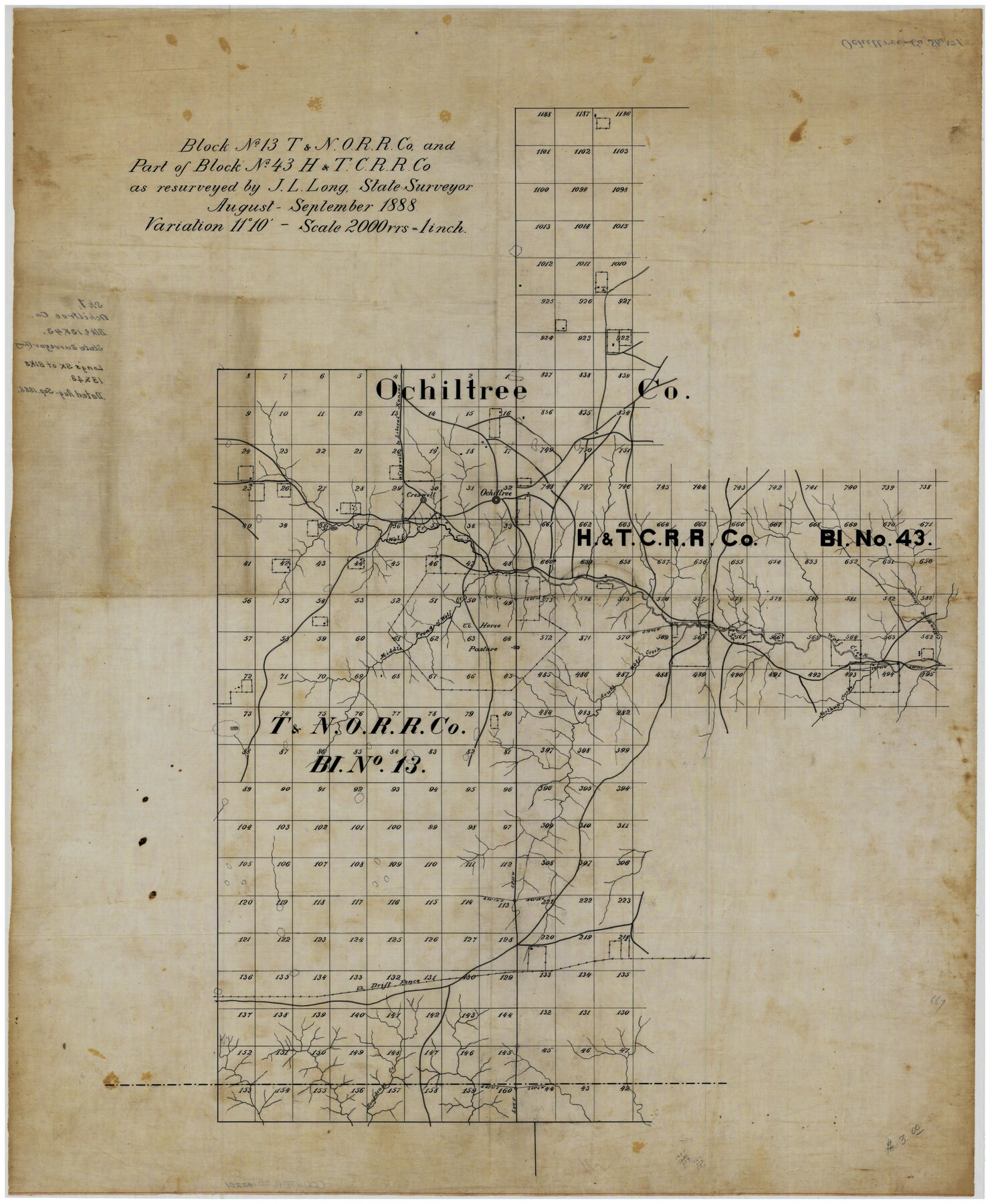
Block No. 13, T. & N. O. R.R. Co. & Part of Block No. 43, H. & T. C. R.R. Co. as resurveyed by J.L. Long, State Surveyor
-
Map/Doc
42201
-
Collection
General Map Collection
-
Object Dates
9/1888 (Creation Date)
Aug.-Sept./1888 (Survey Date)
-
People and Organizations
J.L. Long (Surveyor/Engineer)
-
Counties
Ochiltree
-
Subjects
Surveying Sketch File
-
Height x Width
30.4 x 26.8 inches
77.2 x 68.1 cm
-
Medium
paper, manuscript
-
Scale
1" = 2000 varas
-
Features
Ochiltree
Creswell
Creswell to Liberal Kansas[Road]
Wolf Creek
Middle Prong of Wolf Creek
South Wolf Creek
Northup Creek
Cottonwood Arroyo
Sourdough Creek
Part of: General Map Collection
Foard County Working Sketch 5b

Print $20.00
- Digital $50.00
Foard County Working Sketch 5b
Size 18.4 x 24.2 inches
Map/Doc 69196
Ward County Rolled Sketch 29

Print $20.00
- Digital $50.00
Ward County Rolled Sketch 29
Size 31.8 x 27.4 inches
Map/Doc 89287
A Map of That Part of Dallas County, lying in Nacogdoches Land District

Print $20.00
- Digital $50.00
A Map of That Part of Dallas County, lying in Nacogdoches Land District
1854
Size 29.9 x 22.6 inches
Map/Doc 4525
Flight Mission No. CON-2R, Frame 55, Stonewall County

Print $20.00
- Digital $50.00
Flight Mission No. CON-2R, Frame 55, Stonewall County
1957
Size 18.3 x 22.0 inches
Map/Doc 86987
Blucher's Directory Map of Corpus Christi and Road Map of Nueces County

Print $20.00
- Digital $50.00
Blucher's Directory Map of Corpus Christi and Road Map of Nueces County
1945
Size 22.6 x 34.3 inches
Map/Doc 94106
Wichita County Sketch File 6

Print $40.00
- Digital $50.00
Wichita County Sketch File 6
Size 12.3 x 12.2 inches
Map/Doc 40045
Haskell County Sketch File 13

Print $37.00
- Digital $50.00
Haskell County Sketch File 13
Size 8.1 x 4.0 inches
Map/Doc 26142
Pecos County Working Sketch Graphic index - northwest part - sheet A

Print $20.00
- Digital $50.00
Pecos County Working Sketch Graphic index - northwest part - sheet A
1975
Size 42.2 x 42.6 inches
Map/Doc 76663
Right of Way and Track Map, The Wichita Falls & Southern Railway

Print $40.00
- Digital $50.00
Right of Way and Track Map, The Wichita Falls & Southern Railway
1942
Size 25.0 x 121.0 inches
Map/Doc 64512
Texas Intracoastal Waterway - Stover Point to Port Brownsville including Brazos Santiago

Print $20.00
- Digital $50.00
Texas Intracoastal Waterway - Stover Point to Port Brownsville including Brazos Santiago
1965
Size 27.5 x 38.9 inches
Map/Doc 73521
Sulphur River, Terry Lake Sheet

Print $20.00
- Digital $50.00
Sulphur River, Terry Lake Sheet
1919
Size 15.7 x 18.3 inches
Map/Doc 78337
Zavala County Sketch File 36

Print $6.00
- Digital $50.00
Zavala County Sketch File 36
1889
Size 10.9 x 8.2 inches
Map/Doc 41399
You may also like
Harris County Boundary File 39 (12)

Print $4.00
- Digital $50.00
Harris County Boundary File 39 (12)
Size 7.7 x 8.1 inches
Map/Doc 54339
Jefferson County Rolled Sketch 13

Print $20.00
- Digital $50.00
Jefferson County Rolled Sketch 13
Size 18.8 x 27.2 inches
Map/Doc 6385
Nolan County Working Sketch 1

Print $20.00
- Digital $50.00
Nolan County Working Sketch 1
1928
Size 17.9 x 17.5 inches
Map/Doc 71292
Live Oak County Sketch File 10

Print $6.00
- Digital $50.00
Live Oak County Sketch File 10
1876
Size 10.0 x 15.5 inches
Map/Doc 30263
Mesa situated in Oldham County, Texas on Survey 90, Block K5

Print $20.00
- Digital $50.00
Mesa situated in Oldham County, Texas on Survey 90, Block K5
1903
Size 15.4 x 14.5 inches
Map/Doc 93010
Webb County Sketch File 13b

Print $3.00
- Digital $50.00
Webb County Sketch File 13b
1893
Size 14.0 x 9.8 inches
Map/Doc 39803
Martin-Ameen Addition, City of Lubbock, South 100 Acres of Southeast Quarter, Section 5, Block E

Print $20.00
- Digital $50.00
Martin-Ameen Addition, City of Lubbock, South 100 Acres of Southeast Quarter, Section 5, Block E
Size 30.9 x 24.6 inches
Map/Doc 92737
Blanco County Working Sketch 31

Print $20.00
- Digital $50.00
Blanco County Working Sketch 31
1972
Size 19.1 x 25.7 inches
Map/Doc 67391
Starr County Rolled Sketch 37

Print $413.00
- Digital $50.00
Starr County Rolled Sketch 37
Size 10.1 x 15.1 inches
Map/Doc 48951
Calhoun County Sketch File 14

Print $20.00
- Digital $50.00
Calhoun County Sketch File 14
1852
Size 22.6 x 16.2 inches
Map/Doc 35980
[H. & T. C. RR. Company Block 47, Sections 47, 48, 49, 50, 51, and 52]
![91221, [H. & T. C. RR. Company Block 47, Sections 47, 48, 49, 50, 51, and 52], Twichell Survey Records](https://historictexasmaps.com/wmedia_w700/maps/91221-1.tif.jpg)
Print $2.00
- Digital $50.00
[H. & T. C. RR. Company Block 47, Sections 47, 48, 49, 50, 51, and 52]
Size 8.5 x 11.2 inches
Map/Doc 91221
Stephens County Working Sketch 17

Print $20.00
- Digital $50.00
Stephens County Working Sketch 17
1968
Size 22.7 x 29.1 inches
Map/Doc 63960