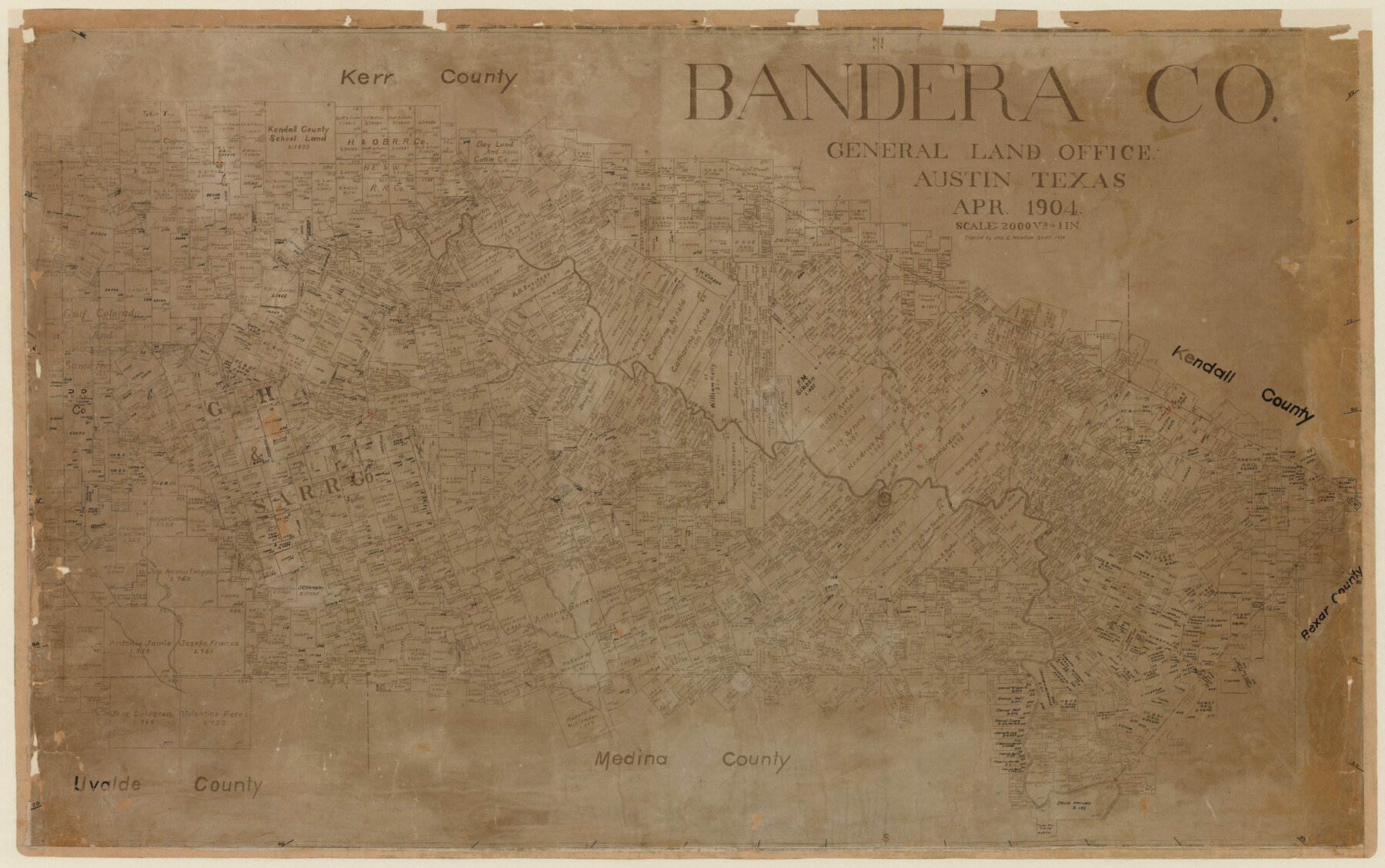
Bandera Co.
-
Map/Doc
4769
-
Collection
General Map Collection
-
Object Dates
1904 (Creation Date)
-
People and Organizations
Texas General Land Office (Publisher)
-
Counties
Bandera
-
Subjects
County
-
Height x Width
31.0 x 49.2 inches
78.7 x 125.0 cm
-
Comments
Traced in September 1918 by Jno. C. Newton.
Copy 1. -
Features
Spires Creek
Middle Verde Creek
Commmissioners Creek
Thomas Creek
Williams Creek
Hondo River
Cañon Creek
Sabinal River
Turkey Creek
Secco Creek
Privilage[sic] Creek
Winans Creek
Masons Creek
West Prong of Medina River
Wards Creek
East Verde Creek
Verde Creek
Old San Antonio Road
San Julian Creek
Bandera
Medina
Medina River
Coker Creek
Bandera Creek
Part of: General Map Collection
Jefferson County Rolled Sketch 26

Print $40.00
- Digital $50.00
Jefferson County Rolled Sketch 26
Size 28.4 x 56.4 inches
Map/Doc 9291
Crockett County Rolled Sketch P

Print $20.00
- Digital $50.00
Crockett County Rolled Sketch P
1927
Size 24.3 x 47.3 inches
Map/Doc 8696
Trinity County Sketch File 12

Print $4.00
- Digital $50.00
Trinity County Sketch File 12
1857
Size 12.8 x 8.0 inches
Map/Doc 38535
[Maps of surveys in Reeves & Culberson Cos]
![61145, [Maps of surveys in Reeves & Culberson Cos], General Map Collection](https://historictexasmaps.com/wmedia_w700/maps/61145.tif.jpg)
Print $20.00
- Digital $50.00
[Maps of surveys in Reeves & Culberson Cos]
1937
Size 30.8 x 25.0 inches
Map/Doc 61145
Hutchinson County Rolled Sketch 18

Print $20.00
- Digital $50.00
Hutchinson County Rolled Sketch 18
Size 30.4 x 32.6 inches
Map/Doc 9244
Trinity County Working Sketch 13

Print $20.00
- Digital $50.00
Trinity County Working Sketch 13
1956
Size 18.2 x 24.7 inches
Map/Doc 69462
Brewster County Rolled Sketch 145

Print $20.00
- Digital $50.00
Brewster County Rolled Sketch 145
1944
Size 24.1 x 18.5 inches
Map/Doc 5312
Crockett County Sketch File 99

Print $14.00
- Digital $50.00
Crockett County Sketch File 99
1925
Size 14.4 x 9.4 inches
Map/Doc 19980
Pecos County Rolled Sketch 60

Print $20.00
- Digital $50.00
Pecos County Rolled Sketch 60
1926
Size 18.3 x 24.2 inches
Map/Doc 7232
Dimmit County Working Sketch 15

Print $20.00
- Digital $50.00
Dimmit County Working Sketch 15
1942
Size 19.0 x 34.5 inches
Map/Doc 68676
Greer County Sketch File 8

Print $20.00
- Digital $50.00
Greer County Sketch File 8
Size 16.7 x 23.6 inches
Map/Doc 11584
Oldham County Working Sketch 8

Print $20.00
- Digital $50.00
Oldham County Working Sketch 8
1982
Size 33.4 x 35.8 inches
Map/Doc 71330
You may also like
Mills County Boundary File 6

Print $2.00
- Digital $50.00
Mills County Boundary File 6
Size 11.0 x 8.6 inches
Map/Doc 57311
Map of Orange County

Print $20.00
- Digital $50.00
Map of Orange County
1880
Size 15.2 x 19.2 inches
Map/Doc 3930
Andrews County Working Sketch 17

Print $20.00
- Digital $50.00
Andrews County Working Sketch 17
1963
Size 30.7 x 27.1 inches
Map/Doc 67063
Stonewall County

Print $40.00
- Digital $50.00
Stonewall County
1888
Size 56.1 x 55.2 inches
Map/Doc 89056
Presidio County Working Sketch 94

Print $20.00
- Digital $50.00
Presidio County Working Sketch 94
1976
Size 40.6 x 32.1 inches
Map/Doc 71771
Hays County Sketch File 29

Print $20.00
- Digital $50.00
Hays County Sketch File 29
1938
Size 21.3 x 31.7 inches
Map/Doc 11751
El Paso County Working Sketch 59

Print $20.00
- Digital $50.00
El Paso County Working Sketch 59
2000
Size 28.1 x 35.7 inches
Map/Doc 69081
Navigation Maps of Gulf Intracoastal Waterway, Port Arthur to Brownsville, Texas

Print $4.00
- Digital $50.00
Navigation Maps of Gulf Intracoastal Waterway, Port Arthur to Brownsville, Texas
1951
Size 16.7 x 21.5 inches
Map/Doc 65424
Leon County Rolled Sketch 13

Print $20.00
- Digital $50.00
Leon County Rolled Sketch 13
1975
Size 22.8 x 22.5 inches
Map/Doc 6600
Kimble County Working Sketch 20

Print $20.00
- Digital $50.00
Kimble County Working Sketch 20
1929
Size 36.2 x 27.8 inches
Map/Doc 70088
Knox County Boundary File 5

Print $14.00
- Digital $50.00
Knox County Boundary File 5
Size 14.2 x 8.6 inches
Map/Doc 65040
Hutchinson County Rolled Sketch 44-11

Print $20.00
- Digital $50.00
Hutchinson County Rolled Sketch 44-11
2002
Size 24.0 x 36.0 inches
Map/Doc 77547