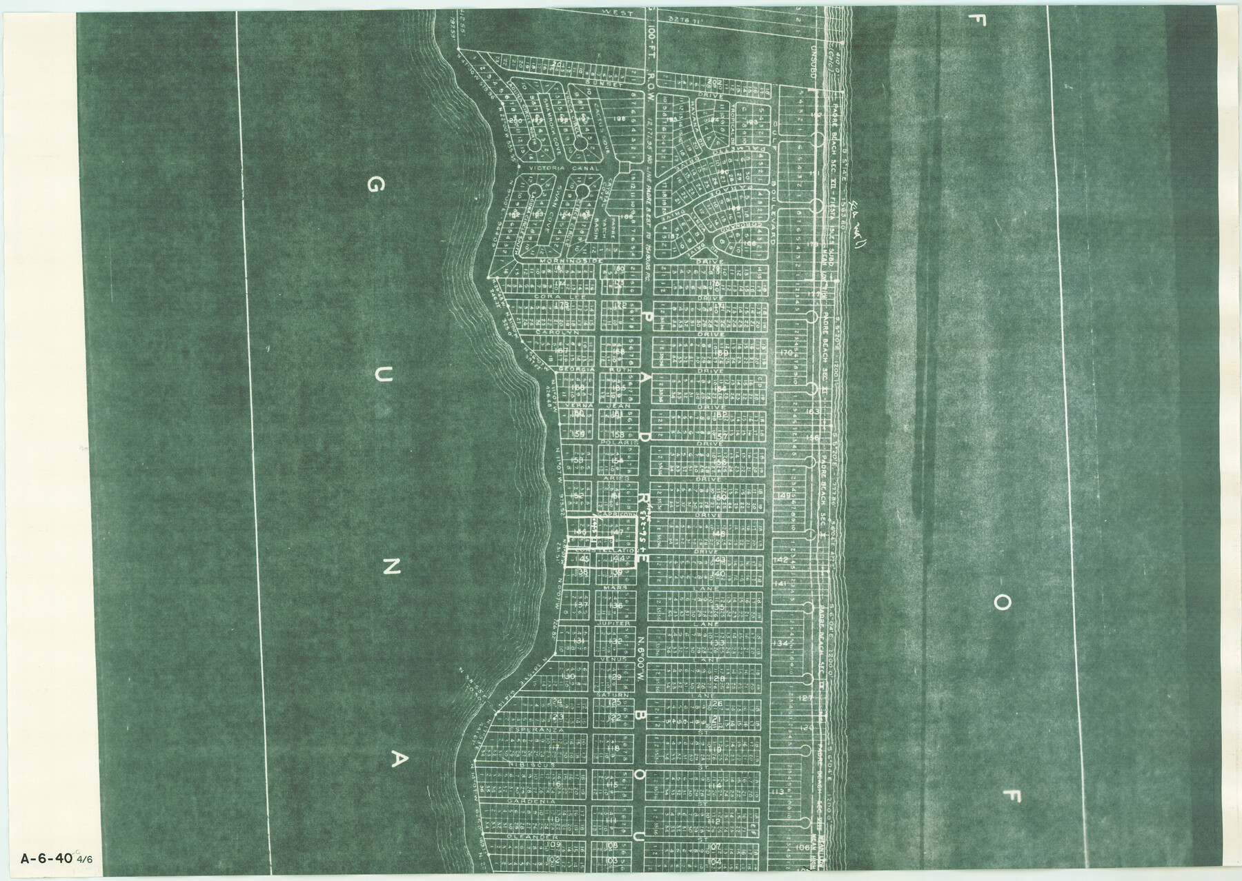
Map of Padre Island Showing Location of Zoning Districts
A-6-40-c
-
Map/Doc
4810
-
Collection
General Map Collection
-
Object Dates
1971/12/1 (Creation Date)
-
People and Organizations
John Huth (Surveyor/Engineer)
FBN (Draftsman)
-
Counties
Cameron
-
Subjects
City
-
Height x Width
18.6 x 26.1 inches
47.2 x 66.3 cm
-
Medium
blueprint/diazo
-
Scale
1" = 400 feet
-
Comments
One of six pieces. Shows south part of Padre Island from Andy Bowie Park to Isla Blanca Park. See map numbers 4808 through 4809 and 4811 through 4813 for other pieces.
-
Features
[Padre Island]
[Gulf of Mexico]
Part of: General Map Collection
Bastrop County Working Sketch 14

Print $20.00
- Digital $50.00
Bastrop County Working Sketch 14
1984
Size 24.5 x 23.4 inches
Map/Doc 67314
Map of Runnels County

Print $20.00
- Digital $50.00
Map of Runnels County
1898
Size 43.2 x 36.9 inches
Map/Doc 16803
King County Working Sketch 6

Print $20.00
- Digital $50.00
King County Working Sketch 6
1944
Size 11.5 x 18.3 inches
Map/Doc 70170
Hemphill County Rolled Sketch 10

Print $20.00
- Digital $50.00
Hemphill County Rolled Sketch 10
Size 19.4 x 27.6 inches
Map/Doc 6192
Jefferson County Sketch File 38

Print $10.00
- Digital $50.00
Jefferson County Sketch File 38
Size 14.2 x 8.9 inches
Map/Doc 28213
[Surveys along Meridian Creek]
![242, [Surveys along Meridian Creek], General Map Collection](https://historictexasmaps.com/wmedia_w700/maps/242.tif.jpg)
Print $2.00
- Digital $50.00
[Surveys along Meridian Creek]
1846
Size 6.4 x 7.7 inches
Map/Doc 242
Uvalde County

Print $20.00
- Digital $50.00
Uvalde County
1915
Size 42.9 x 46.2 inches
Map/Doc 63091
West End of Copano Bay and Town of Saint Marys, Texas

Print $40.00
- Digital $50.00
West End of Copano Bay and Town of Saint Marys, Texas
1861
Size 54.5 x 32.9 inches
Map/Doc 73428
Hudspeth County Sketch File 4b

Print $20.00
- Digital $50.00
Hudspeth County Sketch File 4b
1860
Size 13.0 x 39.2 inches
Map/Doc 10492
Cass County Working Sketch 43

Print $20.00
- Digital $50.00
Cass County Working Sketch 43
1988
Size 25.6 x 29.6 inches
Map/Doc 67946
Maverick County Working Sketch 4

Print $40.00
- Digital $50.00
Maverick County Working Sketch 4
1944
Size 51.3 x 30.7 inches
Map/Doc 70896
Garza County Sketch File 5

Print $14.00
- Digital $50.00
Garza County Sketch File 5
1885
Size 9.8 x 8.1 inches
Map/Doc 24050
You may also like
Webb County Sketch File 12-2

Print $20.00
- Digital $50.00
Webb County Sketch File 12-2
1936
Size 24.5 x 20.1 inches
Map/Doc 12630
The Republic County of Brazos. December 29, 1845

Print $20.00
The Republic County of Brazos. December 29, 1845
2020
Size 20.6 x 21.7 inches
Map/Doc 96117
City of Plainview, Hale County, Texas

Print $40.00
- Digital $50.00
City of Plainview, Hale County, Texas
Size 43.5 x 53.3 inches
Map/Doc 89841
Rains County Working Sketch 5

Print $20.00
- Digital $50.00
Rains County Working Sketch 5
1950
Size 35.2 x 42.0 inches
Map/Doc 71831
Flight Mission No. CRC-4R, Frame 160, Chambers County

Print $20.00
- Digital $50.00
Flight Mission No. CRC-4R, Frame 160, Chambers County
1956
Size 18.5 x 22.3 inches
Map/Doc 84919
Coleman County Sketch File 2

Print $2.00
- Digital $50.00
Coleman County Sketch File 2
Size 8.4 x 3.3 inches
Map/Doc 18669
Brazoria County Sketch File 54

Print $8.00
- Digital $50.00
Brazoria County Sketch File 54
1838
Size 13.4 x 8.2 inches
Map/Doc 15323
Nueces County Rolled Sketch 36

Print $199.00
- Digital $50.00
Nueces County Rolled Sketch 36
Size 10.7 x 15.2 inches
Map/Doc 47617
King County, Texas

Print $20.00
- Digital $50.00
King County, Texas
1880
Size 20.0 x 19.4 inches
Map/Doc 737
Cherokee County Working Sketch 16

Print $20.00
- Digital $50.00
Cherokee County Working Sketch 16
1958
Size 21.9 x 22.5 inches
Map/Doc 67971

Galveston County NRC Article 33.136 Sketch 98

Print $32.00
Galveston County NRC Article 33.136 Sketch 98
2024
Map/Doc 97409