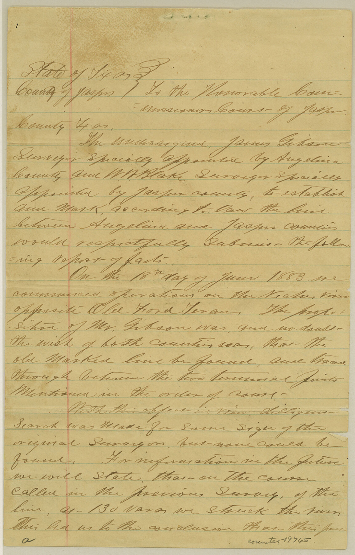
Angelina County Boundary File 1
Court Order to Survey the County Line between Angelina and Jasper Counties; Field Notes of County Lines between Angelina and Jasper Counties
-
Map/Doc
49765
-
Collection
General Map Collection
-
Counties
Angelina
-
Subjects
County Boundaries
-
Height x Width
12.9 x 8.3 inches
32.8 x 21.1 cm
Part of: General Map Collection
Flight Mission No. DAG-21K, Frame 126, Matagorda County

Print $20.00
- Digital $50.00
Flight Mission No. DAG-21K, Frame 126, Matagorda County
1952
Size 18.5 x 22.3 inches
Map/Doc 86452
Crockett County Rolled Sketch CRV

Print $40.00
- Digital $50.00
Crockett County Rolled Sketch CRV
1925
Size 35.8 x 52.3 inches
Map/Doc 8693
Dimmit County Sketch File 47

Print $24.00
- Digital $50.00
Dimmit County Sketch File 47
1908
Size 11.2 x 9.0 inches
Map/Doc 21178
Nueces County NRC Article 33.136 Sketch 15

Print $40.00
- Digital $50.00
Nueces County NRC Article 33.136 Sketch 15
2012
Size 18.0 x 24.0 inches
Map/Doc 93357
Harris County Sketch File 69a

Print $20.00
- Digital $50.00
Harris County Sketch File 69a
1938
Size 19.4 x 21.3 inches
Map/Doc 11663
Hansford County Working Sketch 7

Print $20.00
- Digital $50.00
Hansford County Working Sketch 7
1969
Size 27.7 x 23.9 inches
Map/Doc 63379
Polk County Working Sketch 4

Print $20.00
- Digital $50.00
Polk County Working Sketch 4
1925
Size 46.3 x 42.6 inches
Map/Doc 71619
Frio County Sketch File A

Print $40.00
- Digital $50.00
Frio County Sketch File A
1878
Size 16.4 x 13.4 inches
Map/Doc 23099
Matagorda County Working Sketch 9

Print $20.00
- Digital $50.00
Matagorda County Working Sketch 9
1954
Size 26.5 x 22.3 inches
Map/Doc 70867
Colorado County Working Sketch 18

Print $20.00
- Digital $50.00
Colorado County Working Sketch 18
1957
Size 31.2 x 37.3 inches
Map/Doc 68118
Terrell County Sketch File 9

Print $12.00
- Digital $50.00
Terrell County Sketch File 9
Size 9.8 x 8.5 inches
Map/Doc 37904
Real County Boundary File 1

Print $8.00
- Digital $50.00
Real County Boundary File 1
Size 9.3 x 5.9 inches
Map/Doc 58191
You may also like
Dimmit County Working Sketch 38

Print $40.00
- Digital $50.00
Dimmit County Working Sketch 38
1966
Size 59.4 x 43.0 inches
Map/Doc 68699
Hudspeth County Sketch File 2

Print $10.00
- Digital $50.00
Hudspeth County Sketch File 2
1900
Size 13.4 x 8.6 inches
Map/Doc 26884
Flight Mission No. DCL-6C, Frame 78, Kenedy County

Print $20.00
- Digital $50.00
Flight Mission No. DCL-6C, Frame 78, Kenedy County
1943
Size 17.5 x 20.7 inches
Map/Doc 85920
Randall County Boundary File 1

Print $26.00
- Digital $50.00
Randall County Boundary File 1
Size 14.0 x 8.5 inches
Map/Doc 58098

Coryell County Sketch File 2

Print $4.00
- Digital $50.00
Coryell County Sketch File 2
Size 13.0 x 8.0 inches
Map/Doc 19338
Menard County Working Sketch 30

Print $20.00
- Digital $50.00
Menard County Working Sketch 30
1974
Size 47.9 x 38.8 inches
Map/Doc 70977
Galveston County Sketch File 66

Print $116.00
- Digital $50.00
Galveston County Sketch File 66
Size 5.0 x 10.0 inches
Map/Doc 23751
Anderson County Working Sketch Graphic Index

Print $40.00
- Digital $50.00
Anderson County Working Sketch Graphic Index
1942
Size 52.0 x 48.3 inches
Map/Doc 76452
Colored Map of Texas Gulf Coast from Sabine River to the Rio Grande

Print $20.00
- Digital $50.00
Colored Map of Texas Gulf Coast from Sabine River to the Rio Grande
1950
Size 44.7 x 43.0 inches
Map/Doc 3014
Somervell Co.

Print $20.00
- Digital $50.00
Somervell Co.
1884
Size 28.0 x 26.8 inches
Map/Doc 63040
Catalogue of the Spanish Collection of the Texas General Land Office

Digital $15.00
Catalogue of the Spanish Collection of the Texas General Land Office
2003
Size 10.8 x 8.5 inches
Map/Doc 83387