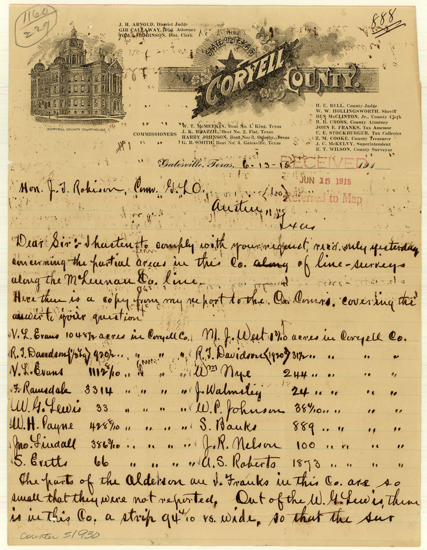
Coryell County Boundary File 4
[Surveyor's Report on acreage along the Coryell-McLennan County line]
-
Map/Doc
51930
-
Collection
General Map Collection
-
Counties
Coryell
-
Subjects
County Boundaries
-
Height x Width
11.2 x 8.7 inches
28.5 x 22.1 cm
Part of: General Map Collection
Gillespie County Sketch File 11

Print $4.00
- Digital $50.00
Gillespie County Sketch File 11
1877
Size 8.3 x 12.8 inches
Map/Doc 24149
Kaufman County Sketch File 18

Print $10.00
- Digital $50.00
Kaufman County Sketch File 18
1936
Size 11.4 x 8.8 inches
Map/Doc 28661
Atascosa County Sketch File 36

Print $20.00
- Digital $50.00
Atascosa County Sketch File 36
1947
Size 16.0 x 22.3 inches
Map/Doc 10867
Hutchinson County Sketch File 4

Print $32.00
- Digital $50.00
Hutchinson County Sketch File 4
1890
Size 14.2 x 8.7 inches
Map/Doc 27179
Nueces County Sketch File 71

Print $19.00
- Digital $50.00
Nueces County Sketch File 71
1991
Size 11.2 x 8.7 inches
Map/Doc 33011
Chambers County NRC Article 33.136 Sketch 8

Print $22.00
- Digital $50.00
Chambers County NRC Article 33.136 Sketch 8
2014
Size 17.7 x 24.0 inches
Map/Doc 94745
Hutchinson County

Print $20.00
- Digital $50.00
Hutchinson County
1922
Size 45.6 x 38.8 inches
Map/Doc 1863
Fisher County Working Sketch 20

Print $20.00
- Digital $50.00
Fisher County Working Sketch 20
1993
Size 38.1 x 26.6 inches
Map/Doc 69154
Navigation Maps of Gulf Intracoastal Waterway, Port Arthur to Brownsville, Texas

Print $4.00
- Digital $50.00
Navigation Maps of Gulf Intracoastal Waterway, Port Arthur to Brownsville, Texas
1951
Size 16.7 x 21.6 inches
Map/Doc 65426
[Sketch for Mineral Application 26501 - Sabine River, T. A. Oldhausen]
![2836, [Sketch for Mineral Application 26501 - Sabine River, T. A. Oldhausen], General Map Collection](https://historictexasmaps.com/wmedia_w700/maps/2836.tif.jpg)
Print $20.00
- Digital $50.00
[Sketch for Mineral Application 26501 - Sabine River, T. A. Oldhausen]
1931
Size 24.4 x 36.5 inches
Map/Doc 2836
Newton County Sketch File 37

Print $6.00
- Digital $50.00
Newton County Sketch File 37
Size 16.2 x 10.7 inches
Map/Doc 32415
Erath County Sketch File A2

Print $20.00
- Digital $50.00
Erath County Sketch File A2
Size 15.9 x 19.5 inches
Map/Doc 11464
You may also like
Harris County Sketch File 19

Print $4.00
- Digital $50.00
Harris County Sketch File 19
1862
Size 8.7 x 13.9 inches
Map/Doc 25366
Flight Mission No. CRC-3R, Frame 29, Chambers County

Print $20.00
- Digital $50.00
Flight Mission No. CRC-3R, Frame 29, Chambers County
1956
Size 18.6 x 22.3 inches
Map/Doc 84804
Lakeview Addition to the City of Shallowater out of the Southeast 1/4 of Section 27, Block D5

Print $3.00
- Digital $50.00
Lakeview Addition to the City of Shallowater out of the Southeast 1/4 of Section 27, Block D5
1955
Size 17.9 x 11.6 inches
Map/Doc 92870


Potter County Boundary File 5a

Print $80.00
- Digital $50.00
Potter County Boundary File 5a
Size 13.0 x 71.0 inches
Map/Doc 58024
Flight Mission No. DAG-17K, Frame 76, Matagorda County

Print $20.00
- Digital $50.00
Flight Mission No. DAG-17K, Frame 76, Matagorda County
1952
Size 16.6 x 16.6 inches
Map/Doc 86335
Shackelford County Working Sketch 14

Print $20.00
- Digital $50.00
Shackelford County Working Sketch 14
2008
Size 47.7 x 29.2 inches
Map/Doc 88835

[Part of H. & G. N. Blocks 2 and D-13]
![90490, [Part of H. & G. N. Blocks 2 and D-13], Twichell Survey Records](https://historictexasmaps.com/wmedia_w700/maps/90490-1.tif.jpg)
Print $20.00
- Digital $50.00
[Part of H. & G. N. Blocks 2 and D-13]
1907
Size 14.1 x 17.7 inches
Map/Doc 90490
Jasper County Sketch File 12b

Print $4.00
- Digital $50.00
Jasper County Sketch File 12b
Size 12.7 x 7.6 inches
Map/Doc 27802
[Blocks O5, A, T1, T2, T3 and vicinity]
![92201, [Blocks O5, A, T1, T2, T3 and vicinity], Twichell Survey Records](https://historictexasmaps.com/wmedia_w700/maps/92201-1.tif.jpg)
Print $20.00
- Digital $50.00
[Blocks O5, A, T1, T2, T3 and vicinity]
Size 20.2 x 23.0 inches
Map/Doc 92201