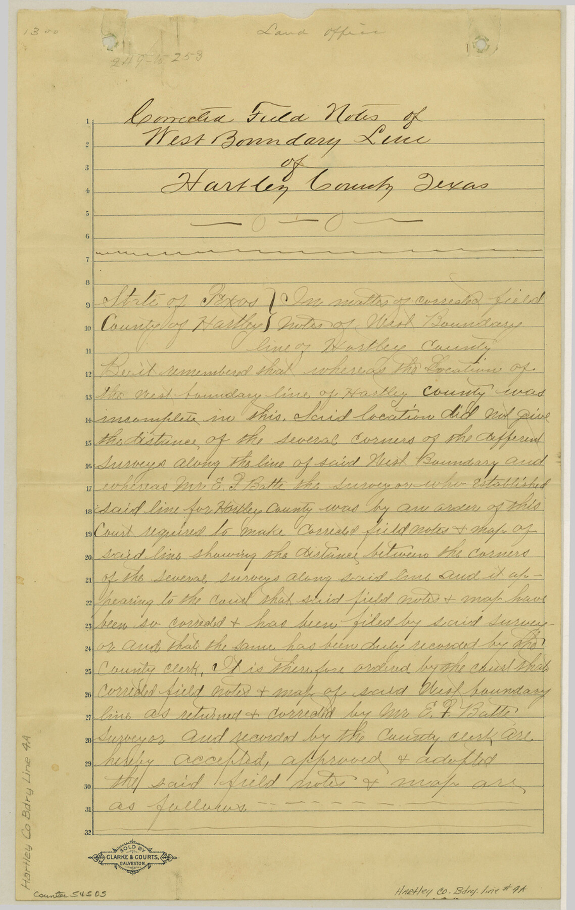
Hartley County Boundary File 4a
Corrected Map and Field Notes of the West Boundary Line of Hartley County Tex.
-
Map/Doc
54505
-
Collection
General Map Collection
-
Counties
Hartley
-
Subjects
County Boundaries
-
Height x Width
14.2 x 9.0 inches
36.1 x 22.9 cm
Part of: General Map Collection
[San Antonio & Aransas Pass R.R. Right of Way from Eagle Lake to Brazos River]
![64256, [San Antonio & Aransas Pass R.R. Right of Way from Eagle Lake to Brazos River], General Map Collection](https://historictexasmaps.com/wmedia_w700/maps/64256.tif.jpg)
Print $40.00
- Digital $50.00
[San Antonio & Aransas Pass R.R. Right of Way from Eagle Lake to Brazos River]
1895
Size 30.8 x 124.9 inches
Map/Doc 64256

Sutton County

Print $40.00
- Digital $50.00
Sutton County
1941
Size 40.9 x 54.3 inches
Map/Doc 77429
Val Verde Co.

Print $20.00
- Digital $50.00
Val Verde Co.
1908
Size 39.8 x 38.7 inches
Map/Doc 63100
Pecos County Sketch File 60

Print $6.00
- Digital $50.00
Pecos County Sketch File 60
Size 8.2 x 16.5 inches
Map/Doc 33786
Callahan County Sketch File 2

Print $8.00
- Digital $50.00
Callahan County Sketch File 2
1858
Size 11.8 x 8.7 inches
Map/Doc 35853
Montgomery County Working Sketch 51

Print $20.00
- Digital $50.00
Montgomery County Working Sketch 51
1960
Size 38.7 x 40.4 inches
Map/Doc 71158
Hamilton County Working Sketch 1

Print $20.00
- Digital $50.00
Hamilton County Working Sketch 1
1914
Size 17.7 x 17.8 inches
Map/Doc 63339
Ward County Working Sketch 43

Print $40.00
- Digital $50.00
Ward County Working Sketch 43
Size 57.3 x 36.8 inches
Map/Doc 72349
Johnson County Working Sketch 13

Print $20.00
- Digital $50.00
Johnson County Working Sketch 13
1969
Size 32.0 x 41.0 inches
Map/Doc 66626
The Spot Map of San Antonio including a classified directory showing location of postal zones, points of interest, places of business - and how to get there

Print $20.00
- Digital $50.00
The Spot Map of San Antonio including a classified directory showing location of postal zones, points of interest, places of business - and how to get there
1941
Size 21.2 x 28.2 inches
Map/Doc 95953
Ride the Texas Independence Trail [Verso]
![94167, Ride the Texas Independence Trail [Verso], General Map Collection](https://historictexasmaps.com/wmedia_w700/maps/94167.tif.jpg)
Ride the Texas Independence Trail [Verso]
1968
Size 18.4 x 24.4 inches
Map/Doc 94167
You may also like
Hemphill County Working Sketch 18

Print $20.00
- Digital $50.00
Hemphill County Working Sketch 18
1972
Size 33.7 x 41.6 inches
Map/Doc 66113
[C. C. S. D. & R. G. N. G. RR. Co. Block G, Waxahachie Tap RR. Co. Block G and D. & W. RR. Co. Block H]
![90859, [C. C. S. D. & R. G. N. G. RR. Co. Block G, Waxahachie Tap RR. Co. Block G and D. & W. RR. Co. Block H], Twichell Survey Records](https://historictexasmaps.com/wmedia_w700/maps/90859-2.tif.jpg)
Print $20.00
- Digital $50.00
[C. C. S. D. & R. G. N. G. RR. Co. Block G, Waxahachie Tap RR. Co. Block G and D. & W. RR. Co. Block H]
1915
Size 22.6 x 11.4 inches
Map/Doc 90859
New Map of the State of Texas Compiled from J. De Cordova's large Map

Print $20.00
- Digital $50.00
New Map of the State of Texas Compiled from J. De Cordova's large Map
1856
Size 17.8 x 27.4 inches
Map/Doc 89252
Tom Green County Rolled Sketch 11

Print $20.00
- Digital $50.00
Tom Green County Rolled Sketch 11
Size 33.0 x 27.9 inches
Map/Doc 7998
Bee County Boundary File 6

Print $4.00
- Digital $50.00
Bee County Boundary File 6
Size 10.4 x 7.9 inches
Map/Doc 50458
Angelina County Sketch File 8

Print $22.00
- Digital $50.00
Angelina County Sketch File 8
1858
Size 8.0 x 3.5 inches
Map/Doc 12935
Stephens County Working Sketch 18

Print $40.00
- Digital $50.00
Stephens County Working Sketch 18
1975
Size 57.4 x 32.9 inches
Map/Doc 63961
Brazoria County Rolled Sketch 28

Print $40.00
- Digital $50.00
Brazoria County Rolled Sketch 28
Size 35.7 x 56.8 inches
Map/Doc 8458
Jim Hogg County Boundary File 2

Print $4.00
- Digital $50.00
Jim Hogg County Boundary File 2
Size 10.6 x 8.7 inches
Map/Doc 55527
Concho County Rolled Sketch 20

Print $20.00
- Digital $50.00
Concho County Rolled Sketch 20
1968
Size 26.2 x 38.8 inches
Map/Doc 5554
Map of the Lands Surveyed by the Memphis, El Paso & Pacific R.R. Company

Print $20.00
- Digital $50.00
Map of the Lands Surveyed by the Memphis, El Paso & Pacific R.R. Company
1859
Size 11.4 x 18.6 inches
Map/Doc 4850
Map of the City of Austin

Print $20.00
- Digital $50.00
Map of the City of Austin
1876
Size 36.5 x 30.4 inches
Map/Doc 78477