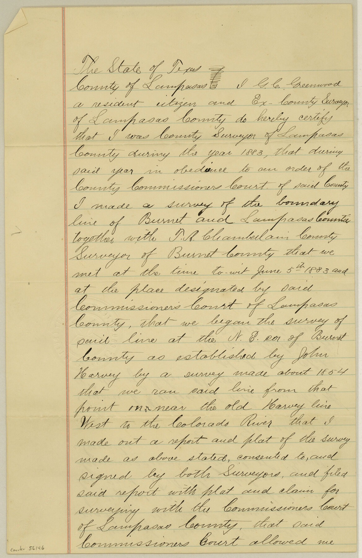
Lampasas County Boundary File 7
Burnet & Lampasas County Line
-
Map/Doc
56146
-
Collection
General Map Collection
-
Counties
Lampasas
-
Subjects
County Boundaries
-
Height x Width
12.7 x 8.3 inches
32.3 x 21.1 cm
Part of: General Map Collection
Kleberg County Rolled Sketch 10-33

Print $20.00
- Digital $50.00
Kleberg County Rolled Sketch 10-33
1950
Size 36.5 x 32.1 inches
Map/Doc 9393
La Salle County Working Sketch 12

Print $20.00
- Digital $50.00
La Salle County Working Sketch 12
1929
Size 25.4 x 15.8 inches
Map/Doc 70313
Aransas Pass to Baffin Bay

Print $20.00
- Digital $50.00
Aransas Pass to Baffin Bay
1961
Size 42.1 x 35.4 inches
Map/Doc 73414
Dallam County Working Sketch 2a

Print $20.00
- Digital $50.00
Dallam County Working Sketch 2a
1886
Size 17.9 x 15.9 inches
Map/Doc 78213

Runnels County Sketch File 29

Print $20.00
Runnels County Sketch File 29
1950
Size 23.8 x 18.0 inches
Map/Doc 12261
Gonzales County

Print $40.00
- Digital $50.00
Gonzales County
1920
Size 48.4 x 44.2 inches
Map/Doc 4706
Schleicher County Sketch File 34

Print $20.00
- Digital $50.00
Schleicher County Sketch File 34
1949
Size 18.7 x 31.7 inches
Map/Doc 12307
Hidalgo County Rolled Sketch 3

Print $20.00
- Digital $50.00
Hidalgo County Rolled Sketch 3
1881
Size 27.0 x 20.3 inches
Map/Doc 6206
Map of Erath County

Print $40.00
- Digital $50.00
Map of Erath County
1896
Size 50.4 x 45.1 inches
Map/Doc 7820
Map of Kendall County

Print $20.00
- Digital $50.00
Map of Kendall County
1899
Size 36.7 x 34.4 inches
Map/Doc 4999
Travis County Rolled Sketch 5

Print $20.00
- Digital $50.00
Travis County Rolled Sketch 5
1924
Size 24.1 x 27.9 inches
Map/Doc 8011
You may also like

G. C. & S. F. Ry., San Saba Branch, Right of Way Map, Brady to Melvin

Print $40.00
- Digital $50.00
G. C. & S. F. Ry., San Saba Branch, Right of Way Map, Brady to Melvin
1916
Size 38.2 x 122.0 inches
Map/Doc 61420
Johnson County, Texas

Print $20.00
- Digital $50.00
Johnson County, Texas
1871
Size 18.2 x 23.3 inches
Map/Doc 734
Presidio County Rolled Sketch 3B

Print $20.00
- Digital $50.00
Presidio County Rolled Sketch 3B
Size 26.2 x 24.1 inches
Map/Doc 7328
Edwards County Rolled Sketch 20

Print $20.00
- Digital $50.00
Edwards County Rolled Sketch 20
1947
Size 31.6 x 40.4 inches
Map/Doc 8844
[Blocks M25, M22, R, and vicinity]
![91240, [Blocks M25, M22, R, and vicinity], Twichell Survey Records](https://historictexasmaps.com/wmedia_w700/maps/91240-1.tif.jpg)
Print $20.00
- Digital $50.00
[Blocks M25, M22, R, and vicinity]
1922
Size 29.0 x 25.7 inches
Map/Doc 91240
Sketch showing W. C. Powell's two lines at south side of Blk. 37, T.5S

Print $20.00
- Digital $50.00
Sketch showing W. C. Powell's two lines at south side of Blk. 37, T.5S
Size 42.8 x 19.6 inches
Map/Doc 93218
Kent County Sketch File 10

Print $42.00
- Digital $50.00
Kent County Sketch File 10
1924
Size 22.1 x 35.5 inches
Map/Doc 11914
Flight Mission No. DQO-3K, Frame 82, Galveston County

Print $20.00
- Digital $50.00
Flight Mission No. DQO-3K, Frame 82, Galveston County
1952
Size 18.7 x 22.5 inches
Map/Doc 85087
[Block AX and vicinity]
![90860, [Block AX and vicinity], Twichell Survey Records](https://historictexasmaps.com/wmedia_w700/maps/90860-2.tif.jpg)
Print $20.00
- Digital $50.00
[Block AX and vicinity]
Size 35.9 x 19.7 inches
Map/Doc 90860
Crockett County Rolled Sketch 45

Print $40.00
- Digital $50.00
Crockett County Rolled Sketch 45
Size 54.8 x 16.5 inches
Map/Doc 8710
Mills County Working Sketch 28

Print $40.00
- Digital $50.00
Mills County Working Sketch 28
2006
Size 42.0 x 67.4 inches
Map/Doc 85385